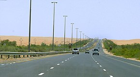
E 66 road (United Arab Emirates)
E 66 | |
|---|---|
| إ ٦٦ | |
 E 66 becomes Dubai – Al Ain Road south of Dubai | |
| Route information | |
| Length | 127.7 km (79.3 mi) |
| Major junctions | |
E 55 | |
| Location | |
| Major cities | Dubai, Al Ain |
| Highway system | |
Highways in the United Arab Emirates Roads in Dubai | |
E 66 (Arabic: إ ٦٦) is a road in the United Arab Emirates. The road connects the city of Dubai to the interior city of Al Ain in the Eastern Region of the Emirate of Abu Dhabi. E 66 runs roughly perpendicular to E 11 (Sheikh Zayed Road) and E 311 (Sheikh Mohammad Bin Zayed Road Road). Beginning in the locality of Oud Metha, E 11 progresses southward towards the interior. The road is referred to as "Dubai-Al Ain Road", after its intersection with Emirates Road south of the city of Dubai, and "Tahnoun Bin Mohammad Al Nahyan Road", after Sheikh Tahnoun, the Ruler's Representative in the Eastern Region of Abu Dhabi.[1]
Contents
1 Description
1.1 Exits
2 History
3 References
Description
It goes through the towns of Al-Faqa' (shared by the Emirates of Abu Dhabi[2] and Dubai)[3] and Al-Hayer,[2] and connects to Al Madam in the Emirate of Sharjah via Al-Shwaib.[1] Once in Al Ain, the road becomes Emirates Street and later, Bani Yas Road.
Exits
| Exit Number | Description |
| 1 | E 11 (Sheikh Zayed Road) |
| 6 | E 44 |
| 9 | Nad Al Sheba Racecourse |
| 14 | E 311 |
| 16 | Dubai International Academic City/Academic City Road |
| 18 | E 611 (Emirates Road) |
| 26 | Umm Nahad |
| 29 | E 77 (to Jebel Ali and Abu Dhabi) |
| 30 | E 77 (to Hatta and Oman) |
| 37 | Al Lusayli |
| 47 | Margham and Dubai Desert Conservation Reserve |
| 50 | Marquab and Dubai Desert Conservation Reserve |
| 50 | Marquab and Dubai Desert Conservation Reserve |
| — | Shwaib, Al Fujairah and eastern towns |
| — | Al-Hayer, Al Sweihan |
| — | Al Kira'a, Bida bin Ahmed |
| — | Al Ain Dairy |
| — | Al Foah, Al Ain City |
History
In 2010, the road had been revamped in two phases. The first phase contained 3 lanes in each direction, and stretched 23 km (14 mi) from Al-Towayya to Al-Masaken. The second phase contained 4 lanes in each direction, and stretched 42 km (26 mi) from Al-Masaken to Al-Faqa'. In November 2018, under the directives of Sheikh Mohammed bin Zayed Al Nahyan, the road was renamed after Sheikh Tahnoun.[1]
References
^ abc "Dubai-Al Ain Road renamed". WAM. Al Ain: Gulf News. 2018-11-02. Retrieved 2018-11-04..mw-parser-output cite.citationfont-style:inherit.mw-parser-output .citation qquotes:"""""""'""'".mw-parser-output .citation .cs1-lock-free abackground:url("//upload.wikimedia.org/wikipedia/commons/thumb/6/65/Lock-green.svg/9px-Lock-green.svg.png")no-repeat;background-position:right .1em center.mw-parser-output .citation .cs1-lock-limited a,.mw-parser-output .citation .cs1-lock-registration abackground:url("//upload.wikimedia.org/wikipedia/commons/thumb/d/d6/Lock-gray-alt-2.svg/9px-Lock-gray-alt-2.svg.png")no-repeat;background-position:right .1em center.mw-parser-output .citation .cs1-lock-subscription abackground:url("//upload.wikimedia.org/wikipedia/commons/thumb/a/aa/Lock-red-alt-2.svg/9px-Lock-red-alt-2.svg.png")no-repeat;background-position:right .1em center.mw-parser-output .cs1-subscription,.mw-parser-output .cs1-registrationcolor:#555.mw-parser-output .cs1-subscription span,.mw-parser-output .cs1-registration spanborder-bottom:1px dotted;cursor:help.mw-parser-output .cs1-ws-icon abackground:url("//upload.wikimedia.org/wikipedia/commons/thumb/4/4c/Wikisource-logo.svg/12px-Wikisource-logo.svg.png")no-repeat;background-position:right .1em center.mw-parser-output code.cs1-codecolor:inherit;background:inherit;border:inherit;padding:inherit.mw-parser-output .cs1-hidden-errordisplay:none;font-size:100%.mw-parser-output .cs1-visible-errorfont-size:100%.mw-parser-output .cs1-maintdisplay:none;color:#33aa33;margin-left:0.3em.mw-parser-output .cs1-subscription,.mw-parser-output .cs1-registration,.mw-parser-output .cs1-formatfont-size:95%.mw-parser-output .cs1-kern-left,.mw-parser-output .cs1-kern-wl-leftpadding-left:0.2em.mw-parser-output .cs1-kern-right,.mw-parser-output .cs1-kern-wl-rightpadding-right:0.2em
^ ab "Eastern Region Bus Services", Department of Transport, Government of Abu Dhabi, retrieved 2018-11-04
^ "Dubai: Crime and accidents down in Al Faqa". Gulf News. 2014-04-14. Retrieved 2018-09-09.
This United Arab Emirates location article is a stub. You can help Wikipedia by expanding it. |
This article about transport in the United Arab Emirates is a stub. You can help Wikipedia by expanding it. |
