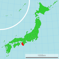
Wakayama Prefecture
Wakayama Prefecture .mw-parser-output .noboldfont-weight:normal 和歌山県 | |||
|---|---|---|---|
Prefecture | |||
| Japanese transcription(s) | |||
| • Japanese | 和歌山県 | ||
| • Rōmaji | Wakayama-ken | ||
| |||
 | |||
| Country | Japan | ||
| Region | Kansai | ||
| Island | Honshū | ||
| Capital | Wakayama (city) | ||
| Government | |||
| • Governor | Yoshinobu Nisaka | ||
| Area | |||
| • Total | 4,725.67 km2 (1,824.59 sq mi) | ||
| Area rank | 30th | ||
| Population (October 1, 2017) | |||
| • Total | 944,320 | ||
| • Rank | 40th | ||
| • Density | 199.87/km2 (517.7/sq mi) | ||
| ISO 3166 code | JP-30 | ||
| Districts | 6 | ||
| Municipalities | 30 | ||
| Flower | Ume blossom (Prunus mume) | ||
| Tree | Ubame oak (Quercus phillyraeoides) | ||
| Bird | Japanese white-eye (Zosterops japonica) | ||
| Website | www.wakayama.lg.jp/ english/ | ||


Wakayama Prefecture (和歌山県, Wakayama-ken) is a prefecture of Japan on the Kii Peninsula in the Kansai region on Honshū island.[1] The capital is the city of Wakayama.[2]
Contents
1 History
1.1 1953 flood disaster
2 Geography
2.1 Cities
2.2 Towns and villages
2.3 Mergers
3 Demographics
4 Politics
5 Culture
6 Agriculture
6.1 Orange
6.2 Japanese apricot (Ume)
7 Sister relationships
8 Tourism
9 Transportation
9.1 Rail
9.2 Road
9.2.1 Expressway
9.2.2 National Highway
9.3 Ferry
9.4 Airport
10 Education
10.1 Universities
11 See also
12 Notes
13 References
14 External links
History
Present-day Wakayama is mostly the western part of the province of Kii.[3]
1953 flood disaster
On July 17–18, 1953, a torrential heavy rain occurred, followed by collapse of levees, river flooding and landslides in a wide area. Many bridges and houses were destroyed. According to an officially confirmed Japanese Government report, 1,015 people died, with 5,709 injured and 7,115 houses lost.[citation needed]
Geography
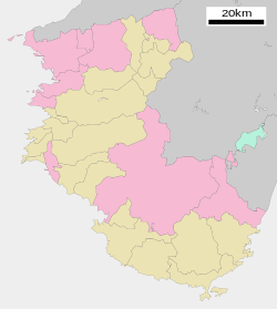
Map of Wakayama Prefecture.
City Town Village
Cities
Nine cities are in Wakayama Prefecture:
|
|
|
Towns and villages
These are the towns and villages in each district:
|
|
|
Mergers
Demographics
Since 1996, population of Wakayama Prefecture has kept declining, and since 2010, it has been the only prefecture in Kinki region with population below 1,000,000. In 2017, Wakayama is ranked 40th by population in Japan with a population of 944,320.
Politics
Culture
Mount Kōya (高野山, Kōya-san) in the Ito District is the headquarters of the Shingon sect of Japanese Buddhism. It is home to one of the first Japanese style Buddhist temples in Japan and remains a pilgrimage site and an increasingly popular tourist destination as people flock to see its ancient temples set amidst the towering cedar trees at the top of the mountain. The Sacred sites and pilgrimage routes in the Kii Mountain Range extend for miles throughout the prefecture and together have been recognized as Japan's 11th UNESCO World Heritage site.[4]
The Kumano Shrines are on the southern tip of the prefecture. Tomogashima (a cluster of four islands) is part of the prefecture.
Agriculture
Orange
Wakayama Prefecture ranks first in the production of oranges in Japan. Wakayama has its own brand of oranges, which is produced in Arida District and called 'Arida-Orange'. Arida District, where oranges have been produced for more than 400 years,[5] yields about half of the orange crops in Wakayama today.[6] Furthermore, the yield of Arida-Oranges accounts for about 10 percent of Japanese domestic production of oranges.[7]
Japanese apricot (Ume)
According to the survey by The Ministry of Agriculture, Forestry and Fisheries of Japan, Wakayama stands first in the production of Japanese apricots in Japan. As of 2016, Wakayama made up about 70 percent of Japanese domestic production of Japanese apricots.[8]
Sister relationships
Wakayama Prefecture has friendship and sister relationships with six places outside Japan:[9]Richmond, Canada; Shandong, People's Republic of China; Pyrénées-Orientales, France; Florida, United States; Sinaloa, Mexico; and Galicia, Spain.
Tourism
Wakayama Prefecture has hot springs such as Shirahama, Kawayu, and Yunomine Onsen.

Saikazaki, Wakanoura

Wakayama Castle

The Museum of Modern Art, Wakayama
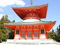
Konpon Daido
(Mount Koya)
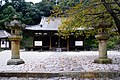
Chōhō-ji

Onsen in Nachikatsuura
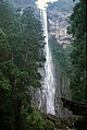
Nachi Falls
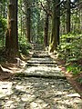
Daimonzaka
(Kumano Kodō)


Transportation
Rail
JR West- Hanwa Line
- Kinokuni Line
- Wakayama Line
JR Central- Kisei Line
Nankai- Nankai Line
- Koya Line
- Kada Line
- Kishu Railway
- Wakayama Electric Railway
Road
Expressway
- Hanwa Expressway
- Keinawa Expressway
- Yuasa Gobo Road
- Nachi Katsuura Road
National Highway
- Route 24
- Route 26
- Route 42
- Route 168 (Shingu-Gojo-Ikoma-Hirakata)
- Route 169 (Shingu-Kumano-Kawakami-Yoshino-Asuka-Kashihara-Nara)
- Route 311 (Kamitonda-Tanabe-Shingu-kumano-Owase)
- Route 370 (Kainan-Hashimoto-Gojo-Uda-Nara)
- Route 371 (Kawachinagano-Hashimoto-Koya-Kushimoto)
- Route 424
Ferry
- Wakayama-Tokushima
Airport
- Nanki Shirahama Airport
Education
Universities
- Wakayama University
- Koyasan University
- Kinki University
- Wakayama Medical University
See also
- Statue of B. R. Ambedkar (Japan)
Notes
^ Nussbaum, Louis-Frédéric. (2005). "Wakayama prefecture" in Japan Encyclopedia, p. 1026, p. 1026, at Google Books; "Kansai" in p. 477, p. 477, at Google Books.
^ Nussbaum, "Wakayama" in p. 1025, p. 1025, at Google Books.
^ Nussbaum, "Provinces and prefectures" in p. 780, p. 780, at Google Books.
^ UNESCO.org
^ 今月の旬 Wakayama Prefecture website, accessed May 31, 2017
^ 農林水産 特産品 Wakayama Prefecture website, accessed May 31, 2017
^ 有田みかんについて JA Arida website, accessed May 31, 2017
^ 作況調査(果樹): 農林水産省 The Ministory of Agriculture, Foresty and Fisheries website, accessed June 1, 2017
^ 友好・姉妹提携 Archived 2011-06-11 at the Wayback Machine. Wakayama Prefecture website, retrieved May 16, 2008
References
- Nussbaum, Louis-Frédéric and Käthe Roth. (2005). Japan encyclopedia. Cambridge: Harvard University Press. .mw-parser-output cite.citationfont-style:inherit.mw-parser-output qquotes:"""""""'""'".mw-parser-output code.cs1-codecolor:inherit;background:inherit;border:inherit;padding:inherit.mw-parser-output .cs1-lock-free abackground:url("//upload.wikimedia.org/wikipedia/commons/thumb/6/65/Lock-green.svg/9px-Lock-green.svg.png")no-repeat;background-position:right .1em center.mw-parser-output .cs1-lock-limited a,.mw-parser-output .cs1-lock-registration abackground:url("//upload.wikimedia.org/wikipedia/commons/thumb/d/d6/Lock-gray-alt-2.svg/9px-Lock-gray-alt-2.svg.png")no-repeat;background-position:right .1em center.mw-parser-output .cs1-lock-subscription abackground:url("//upload.wikimedia.org/wikipedia/commons/thumb/a/aa/Lock-red-alt-2.svg/9px-Lock-red-alt-2.svg.png")no-repeat;background-position:right .1em center.mw-parser-output .cs1-subscription,.mw-parser-output .cs1-registrationcolor:#555.mw-parser-output .cs1-subscription span,.mw-parser-output .cs1-registration spanborder-bottom:1px dotted;cursor:help.mw-parser-output .cs1-hidden-errordisplay:none;font-size:100%.mw-parser-output .cs1-visible-errorfont-size:100%.mw-parser-output .cs1-subscription,.mw-parser-output .cs1-registration,.mw-parser-output .cs1-formatfont-size:95%.mw-parser-output .cs1-kern-left,.mw-parser-output .cs1-kern-wl-leftpadding-left:0.2em.mw-parser-output .cs1-kern-right,.mw-parser-output .cs1-kern-wl-rightpadding-right:0.2em
ISBN 978-0-674-01753-5; OCLC 58053128
External links
| Wikimedia Commons has media related to Wakayama prefecture. |
- Official Wakayama Prefecture homepage
- Wakayama Tourist Guide
- Nanki Sightseeing Guide
Wakayama (capital) | ||
| Core city |
| |
| Cities |
| |
| Districts |
| |
List of mergers in Wakayama Prefecture | ||
| Regions |
|  | |||||||||||||||
|---|---|---|---|---|---|---|---|---|---|---|---|---|---|---|---|---|---|
| 47 Prefectures |
| ||||||||||||||||
Coordinates: 34°3′N 135°21′E / 34.050°N 135.350°E / 34.050; 135.350
Authority control |
|
|---|


