Ibaraki Prefecture
This article may be expanded with text translated from the corresponding article in Japanese. (December 2016) Click [show] for important translation instructions.
|
Ibaraki Prefecture .mw-parser-output .noboldfont-weight:normal 茨城県 | |||
|---|---|---|---|
Prefecture | |||
| Japanese transcription(s) | |||
| • Japanese | 茨城県 | ||
| • Rōmaji | Ibaraki-ken | ||
| |||
 | |||
| Country | Japan | ||
| Region | Kantō | ||
| Island | Honshu | ||
| Capital | Mito | ||
| Government | |||
| • Governor | Kazuhiko Ōigawa | ||
| Area | |||
| • Total | 6,095.58 km2 (2,353.52 sq mi) | ||
| Area rank | 23rd | ||
| Population (February 1, 2017) | |||
| • Total | 2,903,925 | ||
| • Rank | 11th | ||
| • Density | 476.40/km2 (1,233.9/sq mi) | ||
| ISO 3166 code | JP-08 | ||
| Districts | 7 | ||
| Municipalities | 44 | ||
| Flower | Rose (Rosa) | ||
| Tree | Ume tree (Prunus mume) | ||
| Bird | Eurasian Skylark (Alauda arvensis) | ||
| Website | www.pref.ibaraki.jp | ||


Ibaraki Prefecture (茨城県, Ibaraki-ken) is a prefecture of Japan, located in the Kantō region.[1] The capital is Mito.[2]
Contents
1 History
2 Geography
2.1 Cities
2.2 Towns and villages
2.3 Mergers
3 Economy
4 Demographics
5 Culture
6 Education
6.1 University
7 Sports
7.1 Football (soccer)
7.2 Volleyball
7.3 Rugby
7.4 Baseball
7.5 Wrestling
7.6 Basketball
8 Tourism
9 Transportation and access
9.1 Railways
9.2 Cable cars
9.3 Roads
9.3.1 Expressways
9.3.2 National highways
9.4 Ports
9.5 Airports
10 Pronunciation
11 See also
12 Notes
13 References
14 External links
History
Ibaraki Prefecture was previously known as Hitachi Province. In 1871, the name of the province became Ibaraki.
Geography

Map of Ibaraki Prefecture
City Town

Mito

Tsukuba

Tsuchiura
Kashima
Ibaraki Prefecture is the northeastern part of the Kantō region, stretching between Tochigi Prefecture and the Pacific Ocean and bounded on the north and south by Fukushima Prefecture and Chiba Prefecture. It also has a border on the southwest with Saitama Prefecture. The northernmost part of the prefecture is mountainous, but most of the prefecture is a flat plain with many lakes.
As of 1 April 2012[update], 15% of the total land area of the prefecture was designated as Natural Parks, namely Suigo-Tsukuba Quasi-National Park and nine Prefectural Natural Parks.[3]
Cities
Thirty-two (32) cities are located in Ibaraki Prefecture:
Mito (capital city of the prefecture)- Bandō
- Chikusei
- Hitachi
- Hitachinaka
- Hitachiōmiya
- Hitachiōta
- Hokota
- Inashiki
- Ishioka
- Itako
- Jōsō
- Kamisu
- Kasama
- Kashima
- Kasumigaura
- Kitaibaraki
- Koga
- Moriya
- Naka
- Namegata
- Omitama
- Ryūgasaki
- Sakuragawa
- Shimotsuma
- Takahagi
- Toride
- Tsuchiura
- Tsukuba
- Tsukubamirai
- Ushiku
- Yūki
Towns and villages
These are the towns and villages in each district:
Higashiibaraki District- Ibaraki
- Ōarai
- Shirosato
Inashiki District- Ami
- Kawachi
- Miho
Kitasōma District- Tone
Kuji District- Daigo
Naka District- Tōkai
Sashima District- Goka
- Sakai
Yūki District- Yachiyo
Mergers
Economy
Ibaraki's industries include energy production, particularly nuclear energy, as well as chemical and precision machining industries. Hitachi is a world wide company as well as a city name where the company was founded.

Pdddy field at Mt. Tsukuba foot

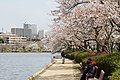
Lotus field and Joban Line

Sweet potato field
Ibaraki is an agricultural prefecture contributing more or less to Japanese dining tables. As of March 2011, the prefecture produced 25% of Japan's bell peppers and Chinese cabbage.[4]
Demographics
Ibaraki's population is decreasing more rapidly than any other prefecture.[5]
Culture
Ibaraki is known for nattō, or fermented soybeans, in Mito, watermelons in Kyōwa (recently merged into Chikusei), and chestnuts in the Nishiibaraki region.
Ibaraki is famous for the martial art of Aikido founded by Ueshiba Morihei, also known as Osensei. Ueshiba spent the latter part of his life in the town of Iwama, now part of Kasama, and the Aiki Shrine and dojo he created still remain.[6]
There are castle ruins in many cities, including Mito, Kasama, and Yūki.
Kasama is famous for Shinto, art culture and pottery.[citation needed]
The capital Mito is home to Kairakuen, one of Japan's three most celebrated gardens, and famous for its over 3,000 Japanese plum trees of over 100 varieties.
Education
University
- Ami
- Ibaraki Prefectural University of Health Sciences
- Hitachi
- Ibaraki Christian University
- Mito
- Ibaraki University
- Tokiwa University
- Tsuchiura
- Tsukuba International University
- Tsukuba
- Tsukuba University
- Tsukuba Gakuin University
- National University Corporation Tsukuba University of Technology
- Ryugasaki
- Ryutsu Keizai University
Sports
The sports teams listed below are based in Ibaraki.
Prefectural Kashima Soccer Stadium
Football (soccer)
Kashima Antlers (Kashima)
Mito HollyHock (Mito)
Volleyball
Hitachi Sawa Rivale (Hitachinaka)
Rugby
- Kashima Rugby Football Club RFC
Baseball
- Ibaraki Golden Golds (Regional club)
Wrestling
- Hitachi Pro Wrestling (Regional group)
Basketball
- Cyberdyne Ibaraki Robots
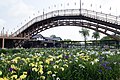
Tourism
- Kairaku-en
- Mount Tsukuba
- Kashima Shrine
- Ibaraki Prefectural Museum of History

A panoramic view of Kasumigaura and Tsuchiura, from Mount Hokyo

Fukuroda waterfalls in Daigo

A view of Mount Tsukuba, from Tsukuba City
A view of Suigo Itako Iris Garden
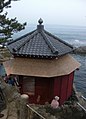
A view of Rokkakudo and Pacific Ocean in Kitaibaraki

Torii of Oarai Coast
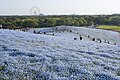
Nemophila in spring in Hitachi Seaside Park
Kairaku-en


Transportation and access
Railways
East Japan Railway Company- Jōban Line
Utsunomiya Line (Tōhoku Main Line)- Mito Line
- Suigun Line
- Kashima Line
- Tsukuba Express
Kantō Railway- Jōsō Line
- Ryūgasaki Line
Kashima Rinkai Railway- Ōarai Kashima Line
- Kashima Rinkō Line
Minato Line (Hitachinaka Seaside Railway)
Mooka Line (Mooka Railway)
Cable cars
- Mount Tsukuba Cable Car
- Mount Tsukuba Ropeway
Roads
Expressways
- Jōban Expressway
- Ken-Ō Expressway
- North Kanto Expressway
- East Kanto Expressway
National highways
National Route 4 (around Koga area)
National Route 6 (Nihonbashi of Tokyo-Toride-Tsuchiura-Mito-Hitachi-Iwaki-Sendai)- National Route 50
National Route 51 (Mito-Kashima-Itako-Narita-Chiba)- National Route 118
- National Route 123
- National Route 124
National Route 125 (Katori-Tsuchiura-Tsukuba-Koga-Gyoda-Kumagaya)- National Route 245
- National Route 293
- National Route 294
- National Route 349
- National Route 354
- National Route 355
National Route 400 (Mito-Nakagawa-Nikko-South Aizu-West Aizu- National Route 408
- National Route 461
Ports
- Port of Ibaraki
- Hitachi Port
- Hitachinaka Port
- Oarai Port - Ferry route to Tomakomai, Muroran of Hokkaido
- Kashima Port
Airports
- Ibaraki Airport
Pronunciation
The prefecture is often alternatively pronounced "Ibaragi" by those who speak the regional dialect known as Ibaraki-ben. However, the correct pronunciation is "Ibaraki". According to the author of "Not Ibaragi, Ibaraki",[7] this is most likely due to a mishearing of the softening of the "k" sound in Ibaraki dialect.
See also
- Ibaraki gubernatorial election, 2005
Notes
^ Nussbaum, Louis-Frédéric. (2005). "Ibaraki-ken" in Japan Encyclopedia, p. 367, at Google Books; "Kantō" in Japan Encyclopedia, p. 479, at Google Books.
^ Nussbaum, "Mito" at Japan Encyclopedia, p. 642, at Google Books.
^ "General overview of area figures for Natural Parks by prefecture" (PDF). Ministry of the Environment. 1 April 2012. Retrieved 9 November 2013..mw-parser-output cite.citationfont-style:inherit.mw-parser-output .citation qquotes:"""""""'""'".mw-parser-output .citation .cs1-lock-free abackground:url("//upload.wikimedia.org/wikipedia/commons/thumb/6/65/Lock-green.svg/9px-Lock-green.svg.png")no-repeat;background-position:right .1em center.mw-parser-output .citation .cs1-lock-limited a,.mw-parser-output .citation .cs1-lock-registration abackground:url("//upload.wikimedia.org/wikipedia/commons/thumb/d/d6/Lock-gray-alt-2.svg/9px-Lock-gray-alt-2.svg.png")no-repeat;background-position:right .1em center.mw-parser-output .citation .cs1-lock-subscription abackground:url("//upload.wikimedia.org/wikipedia/commons/thumb/a/aa/Lock-red-alt-2.svg/9px-Lock-red-alt-2.svg.png")no-repeat;background-position:right .1em center.mw-parser-output .cs1-subscription,.mw-parser-output .cs1-registrationcolor:#555.mw-parser-output .cs1-subscription span,.mw-parser-output .cs1-registration spanborder-bottom:1px dotted;cursor:help.mw-parser-output .cs1-ws-icon abackground:url("//upload.wikimedia.org/wikipedia/commons/thumb/4/4c/Wikisource-logo.svg/12px-Wikisource-logo.svg.png")no-repeat;background-position:right .1em center.mw-parser-output code.cs1-codecolor:inherit;background:inherit;border:inherit;padding:inherit.mw-parser-output .cs1-hidden-errordisplay:none;font-size:100%.mw-parser-output .cs1-visible-errorfont-size:100%.mw-parser-output .cs1-maintdisplay:none;color:#33aa33;margin-left:0.3em.mw-parser-output .cs1-subscription,.mw-parser-output .cs1-registration,.mw-parser-output .cs1-formatfont-size:95%.mw-parser-output .cs1-kern-left,.mw-parser-output .cs1-kern-wl-leftpadding-left:0.2em.mw-parser-output .cs1-kern-right,.mw-parser-output .cs1-kern-wl-rightpadding-right:0.2em
^ Schreiber, Mark, "Japan's food crisis goes beyond recent panic buying", The Japan Times, 17 April 2011, p. 9.
^ "Gov't data show exodus to Tokyo from other parts of Japan continues". Japan Today. 1 February 2019. Archived from the original on 3 February 2019.
^ Aikikai Foundation Ibaraki Branch Dojo "[1] Founder and Iwama", Retrieved August 25 2017
^ いばらぎじゃなくていばらき [Ibaragi ja Nakute Ibaraki]
References
- Nussbaum, Louis-Frédéric and Käthe Roth. (2005). Japan Encyclopedia. Cambridge: Harvard University Press.
ISBN 978-0-674-01753-5.
OCLC 58053128.
External links
| Wikivoyage has a travel guide for Ibaraki. |
| Wikimedia Commons has media related to Ibaraki prefecture. |
Ibaraki Prefecture Official Website (in Japanese)
Ibaraki Prefecture Official Website (in English)
Mito (capital) | ||
| Special cities |
| |
| Cities |
| |
| Districts |
| |
List of mergers in Ibaraki Prefecture | ||
| Regions |
|  | |||||||||||||||
|---|---|---|---|---|---|---|---|---|---|---|---|---|---|---|---|---|---|
| 47 Prefectures |
| ||||||||||||||||
Coordinates: 36°14′N 140°17′E / 36.233°N 140.283°E / 36.233; 140.283
Authority control |
|
|---|


