Yuncheng County
Yuncheng County .mw-parser-output .noboldfont-weight:normal 郓城县 | |
|---|---|
County | |
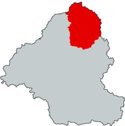 Yuncheng in Heze | |
 Heze in Shandong | |
| Coordinates: 35°35′59″N 115°56′37″E / 35.5998°N 115.9436°E / 35.5998; 115.9436Coordinates: 35°35′59″N 115°56′37″E / 35.5998°N 115.9436°E / 35.5998; 115.9436 | |
| Country | People's Republic of China |
| Province | Shandong |
| Prefecture-level city | Heze |
| Area | |
| • Total | 1,643 km2 (634 sq mi) |
| Population | |
| • Total | 1,094,700 |
| • Density | 670/km2 (1,700/sq mi) |
| Time zone | UTC+8 (China Standard) |
| Postal code | 274009 |
| Area code(s) | 0530 |
Yuncheng (simplified Chinese: 郓城; traditional Chinese: 鄆城; pinyin: Yùnchéng) is a county in the southwest of Shandong province, China. It is the northernmost county-level division of the prefecture-level city of Heze. It borders the Yellow River and Henan (Taiqian County and Fan County) to the north, Liangshan County to the northeast, Jiaxiang County to the east, Juye County to the southeast, and Mudan District to the southwest, and Juancheng County to the west. It stretches 44 km (27 mi) from north to south and 36 km (22 mi) from east to west.
Transportation
- China National Highway 220
Notable natives
Peng Liyuan, Spouse of the President of the People's Republic of China
Ma Xingrui, scientist and current party chief of Shenzhen
Notes and references
County-level divisions of Shandong Province | |||||||||||||||||||||||||||||||
|---|---|---|---|---|---|---|---|---|---|---|---|---|---|---|---|---|---|---|---|---|---|---|---|---|---|---|---|---|---|---|---|
Jinan (capital) | |||||||||||||||||||||||||||||||
| Sub-provincial cities |
| ||||||||||||||||||||||||||||||
| Prefecture-level cities |
| ||||||||||||||||||||||||||||||
| |||||||||||||||||||||||||||||||
This Shandong location article is a stub. You can help Wikipedia by expanding it. |


