Wiltshire
| Wiltshire | |||
|---|---|---|---|
| County | |||
| |||
 | |||
| Coordinates: 51°20′N 1°55′W / 51.333°N 1.917°W / 51.333; -1.917Coordinates: 51°20′N 1°55′W / 51.333°N 1.917°W / 51.333; -1.917 | |||
| Sovereign state | United Kingdom | ||
| Constituent country | England | ||
| Region | South West | ||
| Established | Ancient | ||
| Ceremonial county | |||
| Lord Lieutenant | Sarah Troughton | ||
| High Sheriff | Nicola Alberry (2018–19) | ||
| Area | 3,485 km2 (1,346 sq mi) | ||
| • Ranked | 14th of 48 | ||
| Population (mid-2017 est.) | 716,400 | ||
| • Ranked | 34th of 48 | ||
| Density | 205/km2 (530/sq mi) | ||
| Ethnicity | 2011 Census, excluding Swindon: 93.4% White British 1.3% Asian 1.2% Mixed Race 0.6% Black 0.2% Other | ||
 Districts of Wiltshire Unitary | |||
| Districts |
| ||
| Members of Parliament | List of MPs | ||
| Police | Wiltshire Police | ||
| Time zone | Greenwich Mean Time (UTC) | ||
| • Summer (DST) | British Summer Time (UTC+1) | ||

Wiltshire (/ˈwɪlt.ʃər, -ʃɪər/)[1] is a county in South West England with an area of 3,485 km2 (1,346 square miles).[2] It is landlocked and borders the counties of Dorset, Somerset, Hampshire, Gloucestershire, Oxfordshire and Berkshire. The county town was originally Wilton, after which the county is named, but Wiltshire Council is now based in the county town of Trowbridge.
Wiltshire is characterised by its high downland and wide valleys. Salisbury Plain is noted for being the location of the Stonehenge and Avebury stone circles and other ancient landmarks, and as a training area for the British Army. The city of Salisbury is notable for its mediaeval cathedral. Important country houses open to the public include Longleat, near Warminster, and the National Trust's Stourhead, near Mere.
Contents
1 Toponymy
2 History
3 Geology, landscape and ecology
3.1 Green belt
4 Climate
5 Economy
6 Government and infrastructure
7 Education
8 Demographics
9 Politics and administration
9.1 Westminster Parliamentary
9.2 Council
10 Sport
11 Principal settlements
12 Places of interest
13 Transport
13.1 Road
13.2 Navigable inland waterways
13.3 Canals subject to restoration
13.4 Rail
13.5 Air
14 See also
15 References and footnotes
16 External links
Toponymy
The county, in the 9th century written as Wiltunscir, later Wiltonshire, is named after the former county town of Wilton.[3]
History

Stonehenge
Wiltshire is notable for its pre-Roman archaeology. The Mesolithic, Neolithic and Bronze Age people that occupied southern Britain built settlements on the hills and downland that cover Wiltshire. Stonehenge and Avebury are perhaps the most famous Neolithic sites in the UK.
In the 6th and 7th centuries Wiltshire was at the western edge of Saxon Britain, as Cranborne Chase and the Somerset Levels prevented the advance to the west. The Battle of Bedwyn was fought in 675 between Escuin, a West Saxon nobleman who had seized the throne of Queen Saxburga, and King Wulfhere of Mercia.[4] In 878 the Danes invaded the county. Following the Norman Conquest, large areas of the country came into the possession of the crown and the church.
At the time of the Domesday Survey the industry of Wiltshire was largely agricultural; 390 mills are mentioned, and vineyards at Tollard and Lacock. In the succeeding centuries sheep-farming was vigorously pursued, and the Cistercian monastery of Stanley exported wool to the Florentine and Flemish markets in the 13th and 14th centuries.
In the 17th century English Civil War Wiltshire was largely Parliamentarian. The Battle of Roundway Down, a Royalist victory, was fought near Devizes.
In 1794 it was decided at a meeting at the Bear Inn in Devizes to raise a body of ten independent troops of Yeomanry for the county of Wiltshire, which formed the basis for what would become the Royal Wiltshire Yeomanry, who served with distinction both at home and abroad, during the Boer War, World War I and World War II. The Royal Wiltshire Yeomanry currently lives on as Y (RWY) Squadron, based in Swindon, and B (RWY) Squadron, based in Salisbury, of the Royal Wessex Yeomanry.[5]
Around 1800 the Kennet and Avon Canal was built through Wiltshire, providing a route for transporting cargoes from Bristol to London until the development of the Great Western Railway.
Information on the 261 civil parishes of Wiltshire is available on Wiltshire Council's Wiltshire Community History[6] website which has maps, demographic data, historic and modern pictures and short histories.
The local nickname for Wiltshire natives is "Moonrakers". This originated from a story of smugglers who managed to foil the local Excise men by hiding their alcohol, possibly French brandy in barrels or kegs, in a village pond. When confronted by the excise men they raked the surface to conceal the submerged contraband with ripples, and claimed that they were trying to rake in a large round cheese visible in the pond, really a reflection of the full moon. The officials took them for simple yokels or mad and left them alone, allowing them to continue with their illegal activities. Many villages claim the tale for their own village pond, but the story is most commonly linked with The Crammer in Devizes.[7][8]
Geology, landscape and ecology

Cherhill White Horse, east of Calne
Two-thirds of Wiltshire, a mostly rural county, lies on chalk, a kind of soft, white, porous limestone that is resistant to erosion, giving it a high chalk downland landscape. This chalk is part of a system of chalk downlands throughout eastern and southern England formed by the rocks of the Chalk Group and stretching from the Dorset Downs in the west to Dover in the east. The largest area of chalk in Wiltshire is Salisbury Plain, which is used mainly for arable agriculture and by the British Army as training ranges. The highest point in the county is the Tan Hill–Milk Hill ridge in the Pewsey Vale, just to the north of Salisbury Plain, at 295 m (968 ft) above sea level.
The chalk uplands run northeast into West Berkshire in the Marlborough Downs ridge, and southwest into Dorset as Cranborne Chase. Cranborne Chase, which straddles the border, has, like Salisbury Plain, yielded much Stone Age and Bronze Age archaeology. The Marlborough Downs are part of the North Wessex Downs AONB (Area of Outstanding Natural Beauty), a 1,730 km2 (670-square-mile) conservation area.
In the northwest of the county, on the border with South Gloucestershire and Bath and North East Somerset, the underlying rock is the resistant oolite limestone of the Cotswolds. Part of the Cotswolds AONB is also in Wiltshire, in the county's northwestern corner.
Between the areas of chalk and limestone downland are clay valleys and vales. The largest of these vales is the Avon Vale. The Avon cuts diagonally through the north of the county, flowing through Bradford-on-Avon and into Bath and Bristol. The Vale of Pewsey has been cut through the chalk into Greensand and Oxford Clay in the centre of the county. In the south west of the county is the Vale of Wardour. The southeast of the county lies on the sandy soils of the northernmost area of the New Forest.
Chalk is a porous rock, so the chalk hills have little surface water. The main settlements in the county are therefore situated at wet points. Notably, Salisbury is situated between the chalk of Salisbury Plain and marshy flood plains.
Green belt
The county has green belt mainly along its western fringes as a part of the extensive Avon green belt, reaching as far as the outskirts of Rudloe/Corsham and Trowbridge, preventing urban sprawl particularly from the latter in the direction of Bradford-on-Avon, and affording further protection to surrounding villages and towns from Bath in Somerset.
Climate
Along with the rest of South West England, Wiltshire has a temperate climate which is generally wetter and milder than the rest of the country.[9] The annual mean temperature is approximately 10 °C (50.0 °F). Seasonal temperature variation is less extreme than most of the United Kingdom because of the adjacent sea temperatures. The summer months of July and August are the warmest with mean daily maxima of approximately 21 °C (69.8 °F). In winter mean minimum temperatures of 1 °C (33.8 °F) or 2 °C (35.6 °F) are common.[9] In the summer the Azores high pressure affects southwest England; however, convective cloud sometimes forms inland, reducing the number of hours of sunshine. Annual sunshine rates are slightly less than the regional average of 1,600 hours.[9]
In December 1998 there were 20 days without sun recorded at Yeovilton. Most of the rainfall in the southwest is caused by Atlantic depressions or by convection. Most of the rainfall in autumn and winter is caused by the Atlantic depressions, which is when they are most active. In summer, a large proportion of the rainfall is caused by sun heating the ground leading to convection and to showers and thunderstorms. Average rainfall is around 700 mm (28 in). About 8–15 days of snowfall is typical. November to March have the highest mean wind speeds, and June to August have the lightest winds. The predominant wind direction is from the southwest.[9]
Economy
This is a chart of trend of regional gross value added (GVA) of Wiltshire at current basic prices[10] with figures in millions of British Pounds Sterling.
| Year | Regional gross value added[11] | Agriculture[12] | Industry[13] | Services[14] |
|---|---|---|---|---|
| 1995 | 4,354 | 217 | 1,393 | 2,743 |
| 2000 | 5,362 | 148 | 1,566 | 3,647 |
| 2003 | 6,463 | 164 | 1,548 | 4,751 |
The Wiltshire economy benefits from the "M4 corridor effect", which attracts business, and the attractiveness of its countryside, towns and villages. The northern part of the county is richer than the southern part, particularly since Swindon is home to national and international corporations such as Honda, Intel, Motorola, Patheon, Catalent (formerly known as Cardinal Health), Becton-Dickinson, WHSmith, Early Learning Centre and Nationwide, with Dyson located in nearby Malmesbury. Wiltshire’s employment structure is distinctive in having a significantly higher number of people in various forms of manufacturing (especially electrical equipment and apparatus, food products, and beverages, furniture, rubber, pharmaceuticals, and plastic goods) than the national average.
In addition, there is higher-than-average employment in public administration and defence, due to the military establishments around the county, particularly around Amesbury and Corsham. There are sizeable British Army barracks at Tidworth, Bulford and Warminster, and the Royal School of Artillery is at Larkhill. Further north, RAF Lyneham was home to the RAF's Hercules C130 fleet until 2011; the MoD Lyneham site is now a centre for Army technical training. Wiltshire is also distinctive for the high proportion of its working-age population who are economically active (86.6% in 1999–2000) and its low unemployment rates. The gross domestic product (GDP) level in Wiltshire did not reach the UK average in 1998, and was only marginally above the rate for South West England.[15]
Government and infrastructure
Service Children's Education has its headquarters in Trenchard Lines in Upavon, Wiltshire.[16]
Education
Wiltshire has thirty county secondary schools, publicly funded, of which the largest is Warminster Kingdown, and eleven independent secondaries, including Marlborough College, St Mary's Calne, Dauntsey's near Devizes, and Warminster School. The county schools are nearly all comprehensives, with the older pattern of education surviving only in Salisbury, which has two grammar schools (South Wilts Grammar School for Girls and Bishop Wordsworth's School) and three non-selective schools. All but two of the county secondary schools in the former districts of West Wiltshire and North Wiltshire have sixth forms, but only half of those in the rest of the county.
There are four further education colleges, which also provide some higher education: New College (Swindon); Wiltshire College (Chippenham, Trowbridge and Salisbury); Salisbury Sixth Form College;[17] and Swindon College. In Salisbury, South Wiltshire UTC specialises in science and engineering for students aged 14 to 19.
Wiltshire is one of the few remaining English counties without a university or university college; the closest university to the county town of Trowbridge is the University of Bath. However, Bath Spa University has a centre at Corsham Court in Corsham, and Oxford Brookes University maintains a minor campus in Swindon (almost 50 km from Oxford). Outline plans for a projected University of Swindon or University of Wiltshire were announced by the Borough of Swindon in November 2008, but the scheme remains uncommitted. Swindon therefore remains the UK's largest centre of population without its own university.
Demographics
The county registered a population of 680,137 in the 2011 Census. Wiltshire (outside Swindon) has a low population density of 1.4 persons per hectare, when compared against 4.1 for England as a whole.[18][19][20]
| Wiltshire | Swindon | Total | |
|---|---|---|---|
| Usual resident population | 470,981 | 209,156 | 680,137 |
| Age 65 or over | 18.1% | 13.7% | 16.8% |
| Density (persons per hectare) | 1.4 | 9.1 | 2.0 |
| Households | 194,194 | 88,360 | 282,554 |
Historical population of Wiltshire county:[21]
| 1801 | 1851 | 1901 | 1951 | 2001 |
|---|---|---|---|---|
| 185,107 | 254,221 | 271,394 | 386,692 | 613,024 |
Politics and administration
Westminster Parliamentary
| Overall number of seats as of 2015 | |||||||||
|---|---|---|---|---|---|---|---|---|---|
| Conservative | Liberal Democrats | Labour | UKIP | Green | Others | ||||
7 | 0 | 0 | 0 | 0 | 0 | ||||
Council
The ceremonial county of Wiltshire consists of two unitary authority areas, Wiltshire and Swindon, governed respectively by Wiltshire Council and Swindon Borough Council.
Until the 2009 structural changes to local government in England, Wiltshire (apart from Swindon) was a two-level county, divided into four local government districts, Kennet, North Wiltshire, Salisbury and West Wiltshire, which existed alongside Wiltshire County Council, covering the same area and carrying out more strategic tasks, such as education and county roads. However, on 1 April 2009 these five local authorities were merged into a single unitary authority called Wiltshire Council. With the abolition of the District of Salisbury, a new Salisbury City Council was created at the same time to carry out several citywide functions and to hold the City's charter.
As a result of elections held in 2017, Wiltshire Council comprises 68 Conservatives, 20 Liberal Democrats, seven Independents and three Labour members. The council is led by Jane Scott (Conservative), who had previously led the former Wiltshire County Council since 2003.
Sport

The County Ground, Swindon is the home of Swindon Town, the only football league club in Wiltshire.
The county is represented in the Football League by Swindon Town, who play at the County Ground stadium near Swindon town centre. They joined the Football League on the creation of the Third Division in 1920, and have remained in the league ever since. Their most notable achievements include winning the Football League Cup in 1969 and the Anglo-Italian Cup in 1970, two successive promotions in 1986 and 1987 (taking them from the Fourth Division to the Second), promotion to the Premier League as Division One play-off winners in 1993 (as inaugural members), the Division Two title in 1996, and their promotion to League One in 2007 after finishing third in League Two.
Chippenham Town are the area's highest ranked non-league football club; they currently play in the National League South after winning the Southern Premier League in 2016/17, with a league record points tally of 103. After Salisbury City went into liquidation in 2014, a new club, Salisbury, was formed and plays in the Southern Premier League.
Wiltshire County Cricket Club play in the Minor Counties league.
Swindon Robins Speedway team, who compete in the top national division, the SGB Premiership, have been at their track at the Blunsdon Abbey Stadium near Swindon since 1949. Swindon Wildcats compete in the English Premier Ice Hockey League, the second tier of British ice hockey, and play their home games at Swindon's Link Centre.
Principal settlements
Wiltshire has twenty-one towns and one city:

A bridge over the River Avon at Bradford-on-Avon in Wiltshire
- Amesbury
- Bradford-on-Avon
- Calne
- Chippenham
- Corsham
- Cricklade
- Devizes
Highworth (Borough of Swindon)- Larkhill
- Ludgershall
- Malmesbury
- Marlborough
- Melksham
- Mere
- Royal Wootton Bassett
Salisbury (city)
Swindon (Borough of Swindon)- Tidworth
- Trowbridge
- Warminster
- Westbury
- Wilton
A list of settlements is at List of places in Wiltshire.
Places of interest
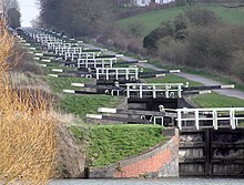
The flight of 16 locks at Caen Hill on the Kennet and Avon Canal
Key | |
Abbey/Priory/Cathedral | |
| Accessible open space | |
Amusement/Theme Park | |
Castle | |
Country Park | |
English Heritage | |
Forestry Commission | |
Heritage railway | |
Historic House | |
Museum (free/not free) | |
National Trust | |
Theatre | |
Zoo | |
Places of interest in Wiltshire include:
- Arc Theatre, part of Wiltshire College, Trowbridge Campus[22]

Ashcombe House
- Arch by Ismbard Kingdom Brunel GWML – Chippenham
Avebury, Neolithic stone circle
- Avebury Manor & Garden
Avon Valley Path
Barbury Castle
- Beckhampton Avenue
Bentley Wood- Biddestone
Bowood House- Butter cross – Chippenham
Burlington, city-sized nuclear bunker with accommodation for 4000 people
Caen Hill Locks, Devizes- Castle Combe
Castle Hill, Mere- Cherhill White Horse
Chisbury Chapel
Coate Water, East Swindon
Corsham Court- Cotswold Water Park
- Courts Garden
- Crofton Pumping Station
Edington Priory
Fonthill Abbey- Great Chalfield Manor
Iford Manor and gardens
Kennet & Avon Canal Museum, Devizes
- King Alfred's Tower
Lacock Abbey
Littlecote House
Longleat Safari Park
Ludgershall Castle, Ludgershall
Lydiard Park & House, West Swindon.- Malmesbury Abbey
- Maud Heath's Causeway
- Mompesson House
Old Sarum, the former cathedral- Philipps House & Dinton Park
Richard Jefferies Birthplace and Museum (The Old House at Coate)
REME Museum
River Thames
Salisbury Cathedral
Salisbury and South Wiltshire Museum- The Science Museum at Wroughton
- Shearwater Lake
- Silbury Hill
- Stonehenge
- Stourhead
Swindon and Cricklade Railway
Swindon Steam Railway Museum
Trafalgar House
Wardour Castle
West Kennet Long Barrow- Westbury White Horse
- Westwood Manor
Woodhenge
Wilton House- Wilton Windmill
- Wilts and Berks Canal
Wiltshire Museum
Win Green Down
- Wroughton
Areas of countryside in Wiltshire include:
Cranborne Chase
Marlborough Downs
Salisbury Plain
Vale of Pewsey
Transport
Road
Roads running through Wiltshire include The Ridgeway, an ancient route, and Roman roads the Fosse Way, London to Bath road and Ermin Way. National Cycle Route 4 and the Thames Path, a modern long distance footpath, run through the county.
Routes through Wiltshire include:
- A4 road
M4 motorway / M4 Corridor
A303 trunk road- A350 road
- A417 road
- River Thames
- Kennet and Avon Canal
Canals subject to restoration
- Thames and Severn Canal
- North Wilts Canal
- Wilts & Berks Canal
Rail
Three main railway routes, all of which carry passenger traffic, cross Wiltshire.
Great Western Main Line (Swindon and Chippenham)
Wessex Main Line (Bradford-on-Avon, Melksham, Trowbridge, Westbury, Warminster, Salisbury; connects to Chippenham)
West of England line (Salisbury and Tisbury)
Other routes include:
- Reading to Taunton Line
- Heart of Wessex Line
- Golden Valley Line
- South Wales Main Line

Swindon station
The major junction stations are Salisbury and Westbury, and important junctions are also found at Swindon, Chippenham and Trowbridge.
There is also the Swindon and Cricklade Railway in the Thames Valley.
In general, Wiltshire is well served by rail, with 14 stations within its boundaries, however there are some towns that are not served such as Calne, Marlborough and Devizes.
Air
Airfields in Wiltshire include Old Sarum Airfield, Clench Common Airfield and Redlands Airfield. RAF Lyneham was an air transport hub for British forces until its closure in 2012. Airports for scheduled airlines near Wiltshire include Bournemouth Airport, Bristol Airport, Bristol Filton Airport, Cardiff Airport, Exeter Airport, Gloucestershire Airport, London Oxford Airport, London Heathrow Airport and Southampton Airport.
See also
- Outline of England
- Flag of Wiltshire
- List of civil parishes in Wiltshire
- List of hills of Wiltshire
- List of places in Wiltshire
- Healthcare in Wiltshire
- Category:Grade I listed buildings in Wiltshire
- Wiltshire Historic Buildings Trust
- List of Sites of Special Scientific Interest in Wiltshire
- Wiltshire local elections
- Swindon local elections
- List of Lords Lieutenant of Wiltshire
- List of Deputy Lieutenants of Wiltshire
- List of High Sheriffs of Wiltshire
Custos Rotulorum of Wiltshire – Keepers of the Rolls- List of Parliamentary constituencies in Wiltshire
- List of MPs for the former Wiltshire constituency
- List of Chairmen of Wiltshire County Council
- Wiltshire Police
- Wiltshire Police and Crime Commissioner
- Wiltshire Horn breed of sheep
- "The Vly be on the Turmut"
References and footnotes
^ "Wiltshire". Collins Dictionary. Retrieved 23 September 2014..mw-parser-output cite.citationfont-style:inherit.mw-parser-output qquotes:"""""""'""'".mw-parser-output code.cs1-codecolor:inherit;background:inherit;border:inherit;padding:inherit.mw-parser-output .cs1-lock-free abackground:url("//upload.wikimedia.org/wikipedia/commons/thumb/6/65/Lock-green.svg/9px-Lock-green.svg.png")no-repeat;background-position:right .1em center.mw-parser-output .cs1-lock-limited a,.mw-parser-output .cs1-lock-registration abackground:url("//upload.wikimedia.org/wikipedia/commons/thumb/d/d6/Lock-gray-alt-2.svg/9px-Lock-gray-alt-2.svg.png")no-repeat;background-position:right .1em center.mw-parser-output .cs1-lock-subscription abackground:url("//upload.wikimedia.org/wikipedia/commons/thumb/a/aa/Lock-red-alt-2.svg/9px-Lock-red-alt-2.svg.png")no-repeat;background-position:right .1em center.mw-parser-output .cs1-subscription,.mw-parser-output .cs1-registrationcolor:#555.mw-parser-output .cs1-subscription span,.mw-parser-output .cs1-registration spanborder-bottom:1px dotted;cursor:help.mw-parser-output .cs1-hidden-errordisplay:none;font-size:100%.mw-parser-output .cs1-visible-errorfont-size:100%.mw-parser-output .cs1-subscription,.mw-parser-output .cs1-registration,.mw-parser-output .cs1-formatfont-size:95%.mw-parser-output .cs1-kern-left,.mw-parser-output .cs1-kern-wl-leftpadding-left:0.2em.mw-parser-output .cs1-kern-right,.mw-parser-output .cs1-kern-wl-rightpadding-right:0.2em
^ [1][permanent dead link]
^ "Wiltshire Community History: Wilton". Wiltshire Council. Archived from the original on 25 July 2011. Retrieved 13 December 2010.
^ Pearson, Michael (2003). Kennet & Avon Middle Thames: Pearson's Canal Companion. Rugby: Central Waterways Supplies. ISBN 0-907864-97-X.
^ British Army Website. "Royal Wessex Yeomanry". Regimental Page. British Army. Archived from the original on 4 March 2016. Retrieved 5 January 2016.
^ "Wiltshire Council - Wiltshire Community History Introduction". Wiltshire.gov.uk. Retrieved 28 September 2017.
^ "The Green and Crammer Pond, Devizes". Devizesheritage.org.uk. Archived from the original on 23 April 2010. Retrieved 28 September 2017.
^ Staff. "Moonraking: The Folklore". Where I live: Wiltshire. BBC Wiltshire. Retrieved 1 December 2008.
^ abcd "South West England: climate". Met Office. Retrieved 16 May 2017.
^ [2][dead link]
^ Components may not sum to totals due to rounding
^ includes hunting and forestry
^ includes energy and construction
^ includes financial intermediation services indirectly measured
^ "Wiltshire Strategic Analysis (2002)" (PDF). Wiltshire CPRE. Archived from the original (PDF) on 1 June 2013. Retrieved 21 October 2006.
^ "SERVICE CHILDREN’S EDUCATION ANNUAL REPORT AND ACCOUNTS 2012–2013" (Archive). Service Children's Education. PDF p. 3/62. Retrieved on 28 February 2015. "Any enquiries regarding this publication should be sent to us at Headquarters Service Children’s Education, Trenchard Lines, Upavon, Wiltshire"
^ "Salisbury Sixth Form College". Salisbury6c.ac.uk. Retrieved 14 December 2018.
^ UK Census (2011). "Local Area Report – Swindon Local Authority (1946157355)". Nomis. Office for National Statistics. Retrieved 17 March 2018.
^ UK Census (2011). "Local Area Report – Wiltshire Local Authority (1946157357)". Nomis. Office for National Statistics. Retrieved 17 March 2018.
^ UK Census (2011). "Local Area Report – England Country (2092957699)". Nomis. Office for National Statistics. Retrieved 17 March 2018.
^ "Wiltshire Community History – Census". Wiltshire Council. Archived from the original on 14 March 2016. Retrieved 21 January 2016.
^ "£2.5 to revamp town college as vocational hub". This is Bath. Western Daily Press. 24 February 2012. Archived from the original on 21 September 2013. Retrieved 4 March 2012.
External links
| Wikimedia Commons has media related to Wiltshire. |
| Wikivoyage has a travel guide for Wiltshire. |
Wiltshire Council
Merlin local information (Wiltshire council)
Wiltshire Community History (Wiltshire council)
Geology map of Wiltshire (PDF) (Wiltshire council)
- Wiltshire Tourist Office
Images of Wiltshire at the English Heritage Archive
Wiltshire at Curlie
Neighbouring counties | ||||||||||
|---|---|---|---|---|---|---|---|---|---|---|
| ||||||||||
| Unitary authorities |
|
|---|---|
| Major settlements |
|
| Rivers |
|
| Topics |
|
| Districts |
|  |
|---|---|---|
| Councils |
| |
| Local elections |
| |


