Southern Patagonian Ice Field
| Southern Patagonian Ice Field | |
|---|---|
 | |
| Type | Ice field |
| Location | Argentina, Chile |
| Coordinates | 49°55′S 73°32′W / 49.917°S 73.533°W / -49.917; -73.533Coordinates: 49°55′S 73°32′W / 49.917°S 73.533°W / -49.917; -73.533 |
| Area | 16,800 km2 (6,500 sq mi) |
| Status | Retreating |
The Southern Patagonian Ice Field (Spanish: Hielo Continental or Campo de Hielo Sur), located at the Southern Patagonic Andes between Chile and Argentina, is the world's second largest contiguous extrapolar ice field.[1] It is the bigger of two remnant parts of the Patagonian Ice Sheet, which covered all of southern Chile during the last glacial period, locally called the Llanquihue glaciation.
Contents
1 Geography
2 History
2.1 Exploration
2.2 Borderline
2.3 Controversy
3 See also
4 References
5 External links
Geography
The Southern Patagonia Ice Field extends from parallels 48° 15′ S to 51° 30′ S for approximately 350 kilometres (220 mi), and has an area of 12,363 km2 (4,773 sq mi), of which roughly 9,700 km2 (3,700 sq mi) fall within Chile and 2,500 km2 (970 sq mi) within Argentina.
The ice mass feeds dozens of glaciers in the area, among which are the Upsala (765 km2), Viedma (978 km2) and Perito Moreno (258 km2) in the Los Glaciares National Park in Argentina, and the Pío XI Glacier or Bruggen Glacier (1,265 km2, the largest in area and longest in the southern hemisphere outside of Antarctica), O'Higgins (820 km2), Grey (270 km2) and Tyndall (331 km2) in Chile. The glaciers going to the west flow into the fjords of the Patagonian channels of the Pacific Ocean; those going to the East flow into the Patagonian lakes Viedma and Argentino, and eventually, through the rivers de la Leona and Santa Cruz, to the Atlantic Ocean.
An important part of the ice field is protected under different national parks, such as the Bernardo O'Higgins and Torres del Paine in Chile, and the aforementioned Los Glaciares in Argentina.
There are two known volcanoes under the ice field; Lautaro and Viedma. Due to their inaccessibility they are among the least researched volcanoes in Chile and Argentina.
History
Exploration
Thorough explorations include the expeditions of Federico Reichert (1913–1914), Alberto de Agostini (1931), and Harold William Tilman and Jorge Quinteros (1955–1956); as well as Eric Shipton (1960–61). The first (North-South) crossing of the field was accomplished in 1998 by Pablo Besser, Mauricio Rojas, José Montt and Rodrigo Fica. Nevertheless, some areas of the field remain largely unexplored
From the air, initial exploration was conducted in 1928–29 by Gunther Plüschow after whom a glacier is named. It was further studied in 1943 by aerial photographs made by the United States Air Force on request of the Chilean government.
Borderline

This map shows the current border, the B Section is pending to be defined.

Toponymy of the region
Fifty kilometers of the Chile–Argentina border, between Mount Fitz Roy and Cerro Murallón, remain undefined[2][3] on the ice field.
This Southern Patagonian Ice Field section of the border is the last remaining border issue between Chile and Argentina. On 1 August 1991 the governments of Chile and Argentina agreed on a borderline, but the agreement was never ratified by the Argentine parliament. Later, in 1998, both governments explicitly agreed that the line would run along the high peaks and watershed (as specified in their 1941 treaty) northward from Cerro Murallón to a point on a line of latitude due west of "Section B" that was specified in the 1998 agreement a few km southwest of Mt. Fitz roy. However, they also agreed that final demarcation and exact location of the line there would wait until completion of a detailed 1:50,000 scale map of the area and further negotiations. To date, this one section remains the final non-concluded boundary section and an occasional irritant in Argentina-Chile relations.
Controversy
In 2006 the Argentine Instituto Geográfico Militar (IGM) (today Instituto Geográfico Nacional) edited a map without a note about the non defined border, instead, the border was the Argentine claims as the official borderline. After Chilean diplomatic protests the Argentine government withdrew the map and urged Chile to expedite the demarcation of the international border that was already established by both countries in the 1881 treaty. However, many in Chile consider the border to have been established by the "Laudo of 1902" which was an agreement signed "to perpetuity" by both countries under British tutelage. The map published by the British Crown, as part of the documentation of the "Laudo of 1902", illustrates a clear demarcation line (from the Fitz Roy to the Stokes) to the east of the Southern Patagonian Ice Fields leaving most of the territory in question in the Chilean side (Santis, 1995:3–7). This is the cartography used by many international map publishers – for many decades – although recently (post 2007) some new international maps show the Argentine claim as the border line.[citation needed]
In January 2008, technicians of both countries began the final demarcation of the border.[4]

Panoramic view of Grey Glacier in Torres del Paine National Park (Chilean territory)

The merged outlet of Penguin Glacier and HPS 19.
In 2018 Argentina made a National Ice Inventory in which are included some disputed glaciers.[5][6][7][8]
From September 20 to October 4 of the same year, the Argentine army traveled to into the area that is pending to be demarcated.
This caused controversy mainly in Chile[9] in where the mayor of Villa O'Higgins denounced the fact as a "provocation" and made a call to the central government of Chile to reinforce the sovereignty in the zone.[10][11]
The head of the Argentine expedition said: "This expedition marks a new precedent with the
presence of the Argentine Army in our Southern Ice Field in the middle of that immensity of
irregular ice, developing the integration between soldiers from different regions ".[12]
The Chancellor Roberto Ampuero lowered the tone to the event and affirmed that neither of the two
countries "needs permission to enter that territory. Chile has done it and now it has just done
Argentina (...) we have an agreement signed in 1998, which establishes that we are setting
which are the borders in the southern zone, near the Ice Field ".[13]
In 2019 the demarcation is still pending.
See also

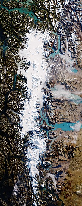
Southern Patagonia Ice Field from ISS, astronaut photo. North is to the right.
- Northern Patagonian Ice Field
- List of glaciers
- Argentina-Chile relations
- Laguna del Desierto incident
- Beagle conflict
- Puna de Atacama dispute
- Glaciarium (museum)
References
^ At about 16,800 square kilometers, it is second only to southeastern Alaska's approximately 25,000 square kilometer Kluane / Wrangell–St. Elias / Glacier Bay / Tatshenshini-Alsek Ice Field. http://whc.unesco.org/en/list/72
^ "Border agreement between Chile and Argentina". Archived from 1998 the original Check|url=value (help) on 2008-05-12. Retrieved 2006-10-27..mw-parser-output cite.citationfont-style:inherit.mw-parser-output .citation qquotes:"""""""'""'".mw-parser-output .citation .cs1-lock-free abackground:url("//upload.wikimedia.org/wikipedia/commons/thumb/6/65/Lock-green.svg/9px-Lock-green.svg.png")no-repeat;background-position:right .1em center.mw-parser-output .citation .cs1-lock-limited a,.mw-parser-output .citation .cs1-lock-registration abackground:url("//upload.wikimedia.org/wikipedia/commons/thumb/d/d6/Lock-gray-alt-2.svg/9px-Lock-gray-alt-2.svg.png")no-repeat;background-position:right .1em center.mw-parser-output .citation .cs1-lock-subscription abackground:url("//upload.wikimedia.org/wikipedia/commons/thumb/a/aa/Lock-red-alt-2.svg/9px-Lock-red-alt-2.svg.png")no-repeat;background-position:right .1em center.mw-parser-output .cs1-subscription,.mw-parser-output .cs1-registrationcolor:#555.mw-parser-output .cs1-subscription span,.mw-parser-output .cs1-registration spanborder-bottom:1px dotted;cursor:help.mw-parser-output .cs1-ws-icon abackground:url("//upload.wikimedia.org/wikipedia/commons/thumb/4/4c/Wikisource-logo.svg/12px-Wikisource-logo.svg.png")no-repeat;background-position:right .1em center.mw-parser-output code.cs1-codecolor:inherit;background:inherit;border:inherit;padding:inherit.mw-parser-output .cs1-hidden-errordisplay:none;font-size:100%.mw-parser-output .cs1-visible-errorfont-size:100%.mw-parser-output .cs1-maintdisplay:none;color:#33aa33;margin-left:0.3em.mw-parser-output .cs1-subscription,.mw-parser-output .cs1-registration,.mw-parser-output .cs1-formatfont-size:95%.mw-parser-output .cs1-kern-left,.mw-parser-output .cs1-kern-wl-leftpadding-left:0.2em.mw-parser-output .cs1-kern-right,.mw-parser-output .cs1-kern-wl-rightpadding-right:0.2em
^ "Map showing border between Chile and Argentina (partly undefined)". Retrieved 2016-06-26.
^ IGM press release: Trazado de Límites en los Hielos Continentales Patagónicos Archived 2008-04-13 at the Wayback Machine
^ "Argentina publica inventario de glaciares e incluye a hielos que están en territorio chileno".
^ "Subcuenca del Lago Viedma - Inventario Nacional de Glaciares" (PDF).
^ "Subcuenca Brazo Norte del Lago Argentino - Inventario Nacional de Glaciares" (PDF).
^ "Subcuencas Brazo Sur del Lago Argentino y río Bote - Inventario Nacional de Glaciares" (PDF).
^ "Malestar en Chile por un ejercicio militar de la Argentina en la zona de Hielos Continentales".
^ "Advierten expedición militar argentina en demarcación limítrofe pendiente en Campo de Hielo Sur".
^ "Polémica por incursión de ejército argentino en territorio chileno en Aysén".
^ "Soldados realizaron una travesía en los hielos continentales".
^ "Canciller desdramatiza incursión argentina en Aysén".
External links
- Expedición Transpatagonia 2007, Campo de Hielo Patagónico Sur. Primera exploración histórica del Cordón del Gaviotín y del Lago Greve
- Expeditions in the SP Ice Field
"Glaciers of the Wet Andes" by Louis Lliboutry, USGS
South Patagonian Icefield, NASA Earth Observatory, 2017. Includes new satellite imagery.
Subsecretario argentino de turismo dice que mapa de Campos de Hielo es oficial "El Mercurio", Chile 29 August 2006
Hielos Continentales: reclamo de Chile por los mapas argentinos Clarín, Argentina 29 August 2006
Tras la fricción por los Hielos Continentales, la Argentina llama a Chile a demarcar los límites "lo antes posible" Clarín, 30 August 1996
Hydrography of Aysén Region | ||
|---|---|---|
| Rivers |
|  |
| Lakes |
| |
| Glaciers |
| |
Hydrography of Magallanes Region | ||
|---|---|---|
| Rivers |
| |
| Waterfalls |
| |
| Lakes |
| |
| Glaciers |
| |
Authority control |
|
|---|

