Coyhaique
Coyhaique Coihaique | ||||||
|---|---|---|---|---|---|---|
City and Commune | ||||||
 Panoramic view of the city | ||||||
| ||||||
| Coordinates (city): 45°34′S 72°04′W / 45.567°S 72.067°W / -45.567; -72.067Coordinates: 45°34′S 72°04′W / 45.567°S 72.067°W / -45.567; -72.067 | ||||||
| Country | Chile | |||||
| Region | Aisén | |||||
| Province | Coihaique | |||||
| Founded as | Baquedano | |||||
| Founded | October 12, 1929 | |||||
| Government [1][2] | ||||||
| • Type | Municipality | |||||
| • Alcalde | Alejandro Huala Canumán (PS) | |||||
| Area [3] | ||||||
| • Total | 7,320.5 km2 (2,826.5 sq mi) | |||||
| Elevation | 302 m (991 ft) | |||||
| Population (2012 Census)[3] | ||||||
| • Total | 53,715 | |||||
| • Density | 7.3/km2 (19/sq mi) | |||||
| • Urban | 44,850 | |||||
| • Rural | 5,191 | |||||
| Demonym(s) | Coyhaiquian | |||||
| Sex [3] | ||||||
| • Men | 25,453 | |||||
| • Women | 24,588 | |||||
| Time zone | UTC−4 (CLT) | |||||
| • Summer (DST) | UTC−3 (CLST) | |||||
| Postal code | 5950000 | |||||
| Area code(s) | 56 + 67 | |||||
| Climate | Cfb | |||||
| Website | Official website (in Spanish) | |||||


Coyhaique (Spanish pronunciation: [koˈʝai̯.ke]), also spelled Coihaique in Patagonia, is the capital city of both the Coyhaique Province and the Aysén Region of Chile. Founded by settlers in 1929, it is a young city. Until the twentieth century, Chile showed little interest in exploiting the remote Aisén region. The Carretera Austral road opened in the 1980s.
Contents
1 Geography and climate
2 Demographics
3 Administration
4 Society and culture
5 Transport and tourism
6 References
7 External links
Geography and climate
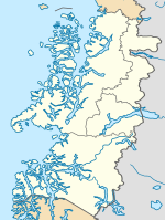
The commune of Coyhaique spans an area of 43,297 km2 (16,717 sq mi).[3] It is surrounded by rivers (Simpson and Coyhaique) and by mountains. The mountains may be snow-covered throughout the year, thus Coihaique is sometimes called the city of eternal snow.
Under the Köppen climate classification, Coyhaique has an oceanic climate (Cfb),[4] though it is considerably less wet than coastal settlements like Puerto Montt or Puerto Aysén since the coastal mountains provide considerable shielding from the westerly winds. Temperatures are moderate during the months of November through April, while from May until October, temperatures are chilly and accompanied by the possibility of snowfall.
| Climate data for Coyhaique (Teniente Vidal Airfield) 1981–2010, extremes 1952–present | |||||||||||||
|---|---|---|---|---|---|---|---|---|---|---|---|---|---|
| Month | Jan | Feb | Mar | Apr | May | Jun | Jul | Aug | Sep | Oct | Nov | Dec | Year |
| Record high °C (°F) | 35.6 (96.1) | 34.0 (93.2) | 31.5 (88.7) | 25.2 (77.4) | 20.4 (68.7) | 18.5 (65.3) | 16.2 (61.2) | 19.0 (66.2) | 23.1 (73.6) | 27.5 (81.5) | 31.0 (87.8) | 32.2 (90.0) | 35.6 (96.1) |
| Average high °C (°F) | 19.1 (66.4) | 19.8 (67.6) | 17.1 (62.8) | 13.2 (55.8) | 8.9 (48.0) | 5.7 (42.3) | 5.6 (42.1) | 8.2 (46.8) | 11.3 (52.3) | 13.8 (56.8) | 15.8 (60.4) | 17.8 (64.0) | 13.0 (55.4) |
| Daily mean °C (°F) | 13.7 (56.7) | 13.6 (56.5) | 11.2 (52.2) | 8.1 (46.6) | 5.0 (41.0) | 2.4 (36.3) | 2.0 (35.6) | 3.7 (38.7) | 6.0 (42.8) | 8.5 (47.3) | 10.6 (51.1) | 12.6 (54.7) | 8.1 (46.6) |
| Average low °C (°F) | 8.9 (48.0) | 8.5 (47.3) | 6.9 (44.4) | 4.7 (40.5) | 2.3 (36.1) | 0.1 (32.2) | −0.5 (31.1) | 0.8 (33.4) | 2.3 (36.1) | 4.2 (39.6) | 6.0 (42.8) | 7.7 (45.9) | 4.3 (39.7) |
| Record low °C (°F) | 0.0 (32.0) | −0.2 (31.6) | −8.0 (17.6) | −8.3 (17.1) | −11.0 (12.2) | −19.2 (−2.6) | −18.0 (−0.4) | −13.4 (7.9) | −8.8 (16.2) | −5.0 (23.0) | −4.2 (24.4) | −2.3 (27.9) | −19.2 (−2.6) |
| Average precipitation mm (inches) | 56.8 (2.24) | 44.1 (1.74) | 70.9 (2.79) | 95.2 (3.75) | 113.6 (4.47) | 141.5 (5.57) | 111.1 (4.37) | 103.8 (4.09) | 64.6 (2.54) | 73.7 (2.90) | 56.7 (2.23) | 59.9 (2.36) | 991.9 (39.05) |
| Average precipitation days | 13 | 10 | 12 | 15 | 19 | 18 | 18 | 18 | 14 | 12 | 13 | 12 | 174 |
| Average relative humidity (%) | 59 | 60 | 64 | 71 | 80 | 82 | 81 | 74 | 67 | 61 | 59 | 59 | 68 |
| Mean monthly sunshine hours | 251.1 | 234.5 | 192.2 | 144.0 | 80.6 | 63.0 | 83.7 | 124.0 | 159.0 | 207.7 | 228.0 | 260.4 | 2,028.2 |
| Mean daily sunshine hours | 8.1 | 8.3 | 6.2 | 4.8 | 2.6 | 2.1 | 2.7 | 4.0 | 5.3 | 6.7 | 7.6 | 8.4 | 5.6 |
| Source #1: Dirección Meteorológica de Chile (precipitation days and humidity 1970–2000)[5][6][7] | |||||||||||||
| Source #2: Universidad de Chile (sunshine hours only)[8] | |||||||||||||
Demographics
According to the 2002 census of the National Statistics Institute, Coyhaique has 50,041 inhabitants (25,453 men and 24,588 women). Of these, 44,850 (89.6%) lived in urban areas and 5,191 (10.4%) in rural areas. The population grew by 15.6% (6,744 persons) between the 1992 and 2002 censuses.[3]
Administration
As a commune, Coyhaique is a third-level administrative division of Chile administered by a municipal council, headed by an alcalde who is directly elected every four years. The 2012-2016 alcalde is Alejandro Huala Canumán (PS).[1][2] He was preceded by Omar Muñoz Sierra (UDI) from 2008 to 2012 and David Sandoval Plaza (also UDI), who served from 2000 to 2008.
Within the electoral divisions of Chile, Coyhaique is represented in the Chamber of Deputies by René Alinco (PDC) and the former mayor David Sandoval as part of the 59th electoral district, which includes the entire Aysén Region. The commune is represented in the Senate by Antonio Horvath Kiss (RN) and Patricio Walker Prieto (PDC) as part of the 18th senatorial constituency (Aysén Region).
Society and culture

Monument to the shepherd
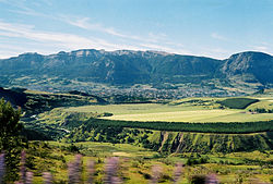
View of Coihaique
The town square is laid out in the shape of a pentagon in honor of the Carabineros, the national police force. A Carabinero general was one of the town's founders.
Transport and tourism
Travelers arrive by air through the local airport, by sea through ships that dock at Puerto Chacabuco (near Puerto Aysén, about one hour to the west of Coyhaique), and by road. Two border crossings near Coyhaique allow entry into Argentina. Fly fishing is popular along its rivers and lakes.
LAN has three daily flights from Santiago to Balmaceda Airport, located 40 km (25 mi) from Coyhaique. Other airlines also provide services. Connections from Balmaceda airport to points further south in Chile will often require a connection in Puerto Montt.
Its sole ski resort, El Fraile, provides two ski lifts and a couple of tracks but no on-site lodging.
- Hotspots
- Simpson and Coyhaique Rivers, well known for fly fishing
- Piedra del Indio, an Indian-shaped rock besides the Simpson River
- Happy Stone, a large rock in the middle of a plain where young people go to party
References
^ ab "Asociación Chilena de Municipalidades" (in Spanish). Retrieved 27 January 2011..mw-parser-output cite.citationfont-style:inherit.mw-parser-output .citation qquotes:"""""""'""'".mw-parser-output .citation .cs1-lock-free abackground:url("//upload.wikimedia.org/wikipedia/commons/thumb/6/65/Lock-green.svg/9px-Lock-green.svg.png")no-repeat;background-position:right .1em center.mw-parser-output .citation .cs1-lock-limited a,.mw-parser-output .citation .cs1-lock-registration abackground:url("//upload.wikimedia.org/wikipedia/commons/thumb/d/d6/Lock-gray-alt-2.svg/9px-Lock-gray-alt-2.svg.png")no-repeat;background-position:right .1em center.mw-parser-output .citation .cs1-lock-subscription abackground:url("//upload.wikimedia.org/wikipedia/commons/thumb/a/aa/Lock-red-alt-2.svg/9px-Lock-red-alt-2.svg.png")no-repeat;background-position:right .1em center.mw-parser-output .cs1-subscription,.mw-parser-output .cs1-registrationcolor:#555.mw-parser-output .cs1-subscription span,.mw-parser-output .cs1-registration spanborder-bottom:1px dotted;cursor:help.mw-parser-output .cs1-ws-icon abackground:url("//upload.wikimedia.org/wikipedia/commons/thumb/4/4c/Wikisource-logo.svg/12px-Wikisource-logo.svg.png")no-repeat;background-position:right .1em center.mw-parser-output code.cs1-codecolor:inherit;background:inherit;border:inherit;padding:inherit.mw-parser-output .cs1-hidden-errordisplay:none;font-size:100%.mw-parser-output .cs1-visible-errorfont-size:100%.mw-parser-output .cs1-maintdisplay:none;color:#33aa33;margin-left:0.3em.mw-parser-output .cs1-subscription,.mw-parser-output .cs1-registration,.mw-parser-output .cs1-formatfont-size:95%.mw-parser-output .cs1-kern-left,.mw-parser-output .cs1-kern-wl-leftpadding-left:0.2em.mw-parser-output .cs1-kern-right,.mw-parser-output .cs1-kern-wl-rightpadding-right:0.2em
^ ab "Municipality of Coihaique" (in Spanish). Retrieved 27 January 2011.
^ abcde "National Statistics Institute" (in Spanish). Retrieved 8 September 2010.
^ Peel, M. C.; Finlayson B. L. & McMahon, T. A. (2007). "Updated world map of the Köppen–Geiger climate classification" (PDF). Hydrol. Earth Syst. Sci. 11: 1633–1644. doi:10.5194/hess-11-1633-2007. ISSN 1027-5606.
^
"Datos Normales y Promedios Históricos Promedios de 30 años o menos" (in Spanish). Dirección Meteorológica de Chile. Retrieved 9 December 2018.
^
"Temperatura Histórica de la Estación Teniente Vidal, Coyhaique Ad. (450004)" (in Spanish). Dirección Meteorológica de Chile. Retrieved 9 December 2018.
^ "Estadistica Climatologica Tomo III (pg 247-270)" (PDF) (in Spanish). Dirección General de Aeronáutica Civil. March 2001. Archived from the original (PDF) on 20 October 2017. Retrieved January 15, 2013.
^ "Tabla 4.6: Medias mensuales de horas de sol diarias extraídas del WRDC ruso (en (hrs./dia))" (PDF). Elementos Para La Creación de Un Manual de Buenas Prácticas Para Instalaciones Solares Térmicas Domiciliarias (in Spanish). Universidad de Chile. September 2007. p. 81. Retrieved 21 January 2015.
External links
| Wikimedia Commons has media related to Coyhaique. |
- Coyhaique's city hall website
Patagonia House, Bed and Breakfast
Salvaje Corazon, Tour Guides
Communes and municipalities in Aysén Region | ||
|---|---|---|
| Aysén |
|  |
| Capitán Prat |
| |
| Coyhaique |
| |
| General Carrera |
| |
Authority control |
|
|---|


