Polder
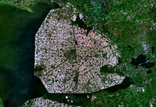
Satellite image of Noordoostpolder, Netherlands (595.41 km²)
A polder (Dutch pronunciation: [ˈpɔldər] (![]() listen)) is a low-lying tract of land enclosed by dikes that form an artificial hydrological entity, meaning it has no connection with outside water other than through manually operated devices. There are three types of polder:
listen)) is a low-lying tract of land enclosed by dikes that form an artificial hydrological entity, meaning it has no connection with outside water other than through manually operated devices. There are three types of polder:
Land reclaimed from a body of water, such as a lake or the sea bed
Flood plains separated from the sea or river by a dike
Marshes separated from the surrounding water by a dike and subsequently drained; these are also known as koogs especially in Germany
The ground level in drained marshes subsides over time. All polders will eventually be below the surrounding water level some or all of the time. Water enters the low-lying polder through infiltration and water pressure of ground water, or rainfall, or transport of water by rivers and canals. This usually means that the polder has an excess of water, which is pumped out or drained by opening sluices at low tide. Care must be taken not to set the internal water level too low. Polder land made up of peat (former marshland) will sink in relation to its previous level, because of peat decomposing when exposed to oxygen from the air.
Polders are at risk from flooding at all times, and care must be taken to protect the surrounding dikes. Dikes are typically built with locally available materials, and each material has its own risks: sand is prone to collapse owing to saturation by water; dry peat is lighter than water and potentially unable to retain water in very dry seasons. Some animals dig tunnels in the barrier, allowing water to infiltrate the structure; the muskrat is known for this activity and hunted in certain European countries because of it. Polders are most commonly, though not exclusively, found in river deltas, former fenlands and coastal areas.
Flooding of polders has also been used as a military tactic in the past. One example is the flooding of the polders along the Yser river during World War I. Opening the sluices at high tide and closing them at low tide turned the polders into an inaccessible swamp which allowed the Allied armies to stop the German army.
Contents
1 Etymology
2 Polders and the Netherlands
3 Examples of polders
3.1 Bangladesh
3.2 Belgium
3.3 Canada
3.4 China
3.5 Denmark
3.6 Finland
3.7 France
3.8 Germany
3.9 Guyana
3.10 India
3.11 Ireland
3.12 Italy
3.13 Lithuania
3.14 Netherlands
3.15 Poland
3.16 Slovenia
3.17 South Korea
3.18 Spain
3.19 United Kingdom
3.20 United States
4 See also
5 References
6 External links
Etymology
From Dutch polder ("polder"), from Middle Dutch polre, from Old Dutch polra, ultimately from pol- "part of land, elevated above its surroundings"; with augmentative suffix -er and epenthetical -d-.
Polders and the Netherlands

Pumping station in Zoetermeer, Netherlands. The polder lies lower than the surrounding water on the other side of the dike. The Archimedes' screws are clearly visible.
The Netherlands is frequently associated with polders, as its engineers became noted for developing techniques to drain wetlands and make them usable for agriculture and other development. This is illustrated by the saying: "God created the world, but the Dutch created the Netherlands[1]".
The Dutch have a long history of reclamation of marshes and fenland, resulting in some 3,000 polders[2] nationwide. By 1961 6,800 square miles (18,000 km2), about half of the country's land, was reclaimed from the sea.[3] About half the total surface area of polders in north-west Europe is in the Netherlands. The first embankments in Europe were constructed in Roman times. The first polders were constructed in the 11th century.
As a result of flooding disasters, water boards called waterschap (when situated more inland) or hoogheemraadschap (near the sea, mainly used in the Holland region)[4] were set up to maintain the integrity of the water defences around polders, maintain the waterways inside a polder, and control the various water levels inside and outside the polder. Water boards hold separate elections, levy taxes, and function independently from other government bodies. Their function is basically unchanged even today. As such they are the oldest democratic institution in the country. The necessary cooperation among all ranks to maintain polder integrity gave its name to the Dutch version of third way politics—the Polder Model.
The 1953 flood disaster prompted a new approach to the design of dikes and other water-retaining structures, based on an acceptable probability of overflowing. Risk is defined as the product of probability and consequences. The potential damage in lives, property and rebuilding costs is compared to the potential cost of water defences. From these calculations follows an acceptable flood risk from the sea at one in 4,000–10,000 years, while it is one in 100–2,500 years for a river flood. The particular established policy guides the Dutch government to improve flood defences as new data on threat levels becomes available.
Some famous Dutch polders and the year they were laid dry are:
Beemster (1609-1612)
Schermer (1633-1635)
Haarlemmermeerpolder (1852)- As part of the Zuiderzee Works:
Wieringermeerpolder (1930)
Noordoostpolder (1942)
Flevopolder (1956-1966)
Examples of polders
Bangladesh
Bangladesh has 123 polders, of which 49 are sea-facing. These were constructed in the 1960s to protect the coast from tidal flooding and reduce salinity incursion.[5] They reduce long-term flooding and waterlogging following storm surges from tropical cyclones. They are also cultivated for agriculture.[6]
Belgium
- De Moeren, near Veurne in West Flanders
- Polders along the Yser rive between Nieuwpoort and Diksmuide
- Polders of Muisbroek and Ettenhoven, in Ekeren and Hoevenen
- Polder of Stabroek, in Stabroek
- Kabeljauwpolder, in Zandvliet
- Scheldepolders on the left bank of the Scheldt
- Uitkerkse polders, near Blankenberge in West Flanders
- Prosperpolder, near Doel, Antwerp and Kieldrecht.
Canada
- Holland Marsh
- Pitt Polder Ecological Reserve
- Grand Pré, Nova Scotia
China
- The city of Kunshan has over 100 polders.[7]
Denmark
- Lammefjorden
Finland
- Söderfjärden
- Munsmo
- Two polders (totally 3 km2) near Vassor in Korsholm
France
- Marais Poitevin
Les Moëres, adjacent to the Flemish polder De Moeren in Belgium.
Germany
In Germany, land reclaimed by dyking is called a koog. The German Deichgraf system was similar to the Dutch and is widely known from Theodor Storm's novella The Rider on the White Horse.
- Altes Land near Hamburg
Blockland & Hollerland near Bremen- Nordstrand, Germany
- Bormerkoog and Meggerkoog near Friedrichstadt
- 36 koogs in the district of Nordfriesland
- 12 koogs in the district of Dithmarschen

Polder operating
In southern Germany, the term polder is used for retention basins recreated by opening dikes during river floodplain restoration, a meaning somewhat opposite to that in coastal context.
Guyana
- Black Bush Polder, Corentyne, Berbice.
India
Kuttanad Region, Kerala[8][9]
Ireland
Lough Swilly, Co. Donegal. Near Inch Island and Newtowncunningham.[10]
Italy
- Delta of the river Po, such as Bonifica Valle del Mezzano
Lithuania
- Rusnė Island
Netherlands
Alblasserwaard, containing the windmills of Kinderdijk, a World Heritage Site- Alkmaar
- Andijk
- Anna Paulownapolder
Beemster, a World Heritage Site- Bijlmermeer
- 's-Gravesloot
Haarlemmermeer, containing Schiphol airport- Krimpenerwaard
- Lauwersmeer
- Mastenbroek
- Noordoostpolder
- Prins Alexanderpolder
- Purmer
- Schermer
- Watergraafsmeer
- Wieringermeer
- Wieringerwaard
- Wijdewormer
- Zestienhoven, home of the Rotterdam The Hague Airport (Overschie), in the city of Rotterdam.
Zuidplaspolder, along with Lammefjord in Denmark the lowest point of the European Union
Flevopolder, the largest artificial island in the world
Poland
Vistula delta near Elbląg and Nowy Dwór Gdański
Warta delta near Kostrzyn nad Odrą
Slovenia
- The Ankaran Polder (Slovene: Ankaranska bonifika), Semedela Polder (Semedelska bonifika), and Škocjan Polder (Škocjanska bonifika) in reclaimed land around Koper
South Korea
- Parts of the coast of Ganghwa Island, adjacent to the river Han in Incheon
- Delta of the river Nakdong in Busan
Saemangeum in Jeollabuk-do
Spain
- Parts of Málaga were built on reclaimed land
United Kingdom
- Traeth Mawr
Sunk Island, on the north shore of the Humber east of Hull
Caldicot and Wentloog Levels along the Severn Estuary in South Wales- Parts of The Fens
Branston Island, by the River Witham outside the conventional area of the fens but connected to them.
- Parts of the coast of Essex
- Some land along the River Plym in Plymouth
- Some land around Meathop east of Grange-over-Sands, reclaimed as a side-effect of building a railway embankment
- The Somerset Levels and North Somerset Levels
- Romney Marsh
United States
- New Orleans
- Sacramento – San Joaquin River Delta
See also
- Flood control in the Netherlands
- Afsluitdijk
- Land reclamation
- IJsselmeer
- Zuiderzee Works
- Windpump
References
^ Forrest Clingerman, Brian Treanor, Martin Drenthen, David Utsler, Interpreting Nature: The Emerging Field of Environmental Hermeneutics, Fordham University Press, 1 sep. 2013.
^ "Kijk naar de geschiedenis". Rijkswaterstaat. Retrieved 2008-01-21..mw-parser-output cite.citationfont-style:inherit.mw-parser-output .citation qquotes:"""""""'""'".mw-parser-output .citation .cs1-lock-free abackground:url("//upload.wikimedia.org/wikipedia/commons/thumb/6/65/Lock-green.svg/9px-Lock-green.svg.png")no-repeat;background-position:right .1em center.mw-parser-output .citation .cs1-lock-limited a,.mw-parser-output .citation .cs1-lock-registration abackground:url("//upload.wikimedia.org/wikipedia/commons/thumb/d/d6/Lock-gray-alt-2.svg/9px-Lock-gray-alt-2.svg.png")no-repeat;background-position:right .1em center.mw-parser-output .citation .cs1-lock-subscription abackground:url("//upload.wikimedia.org/wikipedia/commons/thumb/a/aa/Lock-red-alt-2.svg/9px-Lock-red-alt-2.svg.png")no-repeat;background-position:right .1em center.mw-parser-output .cs1-subscription,.mw-parser-output .cs1-registrationcolor:#555.mw-parser-output .cs1-subscription span,.mw-parser-output .cs1-registration spanborder-bottom:1px dotted;cursor:help.mw-parser-output .cs1-ws-icon abackground:url("//upload.wikimedia.org/wikipedia/commons/thumb/4/4c/Wikisource-logo.svg/12px-Wikisource-logo.svg.png")no-repeat;background-position:right .1em center.mw-parser-output code.cs1-codecolor:inherit;background:inherit;border:inherit;padding:inherit.mw-parser-output .cs1-hidden-errordisplay:none;font-size:100%.mw-parser-output .cs1-visible-errorfont-size:100%.mw-parser-output .cs1-maintdisplay:none;color:#33aa33;margin-left:0.3em.mw-parser-output .cs1-subscription,.mw-parser-output .cs1-registration,.mw-parser-output .cs1-formatfont-size:95%.mw-parser-output .cs1-kern-left,.mw-parser-output .cs1-kern-wl-leftpadding-left:0.2em.mw-parser-output .cs1-kern-right,.mw-parser-output .cs1-kern-wl-rightpadding-right:0.2em
[permanent dead link]
^ Ley, Willy (October 1961). "The Home-Made Land". For Your Information. Galaxy Science Fiction. pp. 92–106.
^ "waterschap". Archived from the original on 2012-11-02.
^ "Bangladesh polders under threat", Irin News
^ "Bangladeshi project to enhance polders amidst climate woes" Archived 2014-04-08 at the Wayback Machine, Unearth News
^ "CRCWSC Trade Mission to Kunshan" (PDF). 2016-12-01.
^ "Rain continues to throw a challenge in Kuttanad". The Hindu. The Hindu Group. 2011. Retrieved 2011-06-10.
^ Thampatti, Manorama (March 1999). "Rice Bowl in Turmoil: The Kuttanad Wetland Ecosystem". Resonance. Indian Academy of Sciences. Archived from the original on 2010-12-16. Retrieved 2011-06-10.
^ "Inch Wildfowl Reserve History". Inch and Foyle Wildfowl Project. Archived from the original on 7 September 2015. Retrieved 5 June 2015.
- Farjon, J.M.J., J. Dirkx, A. Koomen, J. Vervloet & W. Lammers. 2001. Neder-landschap Internationaal: bouwstenen voor een selectie van gebieden landschapsbehoud. Alterra, Wageningen. Rapport 358.
- Morten Stenak. 2005. De inddæmmede Landskaber - En historisk geografi. Landbohistorik Selskab.
- Ven, G.P. van de (red.) 1993. Leefbaar laagland: geschiedenis van waterbeheersing en landaanwinning in Nederland. Matrijs, Utrecht.
- Wagret, P. 1972. Polderlands. London: Methuen.
External links
| Wikimedia Commons has media related to Polders. |
Polder landscapes in the Netherlands — in a northwest European and a landmark context.- How to make a polder — online film
Authority control |
|
|---|