North European Plain
This article includes a list of references, related reading or external links, but its sources remain unclear because it lacks inline citations. (December 2017) (Learn how and when to remove this template message) |
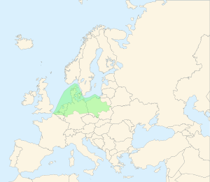
North European Plain coloured in green.

Topography of Europe.
The North European Plain (German: Norddeutsches Tiefland, North German Plain, or Mitteleuropäische Tiefebene, Polish: Nizina Środkowoeuropejska, Middle European Plain, Danish: Nordeuropæiske Lavland, Dutch: Noord-Europese Laagvlakte, Northern European Plain) is a geomorphological region in Europe, mostly in Poland, Denmark, Germany, Belgium, the Netherlands (Low Countries), with small parts of northern France and Czech republic.
It consists of the low plains between the Hercynian Europe (Central European Highlands) to the south and coastlines of the North Sea and the Baltic Sea to the north. These two seas are separated by the Jutland Peninsula (Denmark). The North European Plain is connected to East European Plain, together forming the European Plain.
Contents
1 Uses
2 Geography
3 Location
4 Rivers
5 Sub-regions
5.1 Baltic Lowland
5.2 Low Countries
5.3 Polish Plains
5.4 English flatlands
6 External links
Uses
The Northern European Plain's main use is commercial farming, with little natural vegetation remaining.[citation needed]
Geography
Elevations vary between 0 and 200 m (0 to about 650 ft). While mostly used as farmland, the region also contains bogs, heath and lakes.
On the North Sea coast one finds the Wadden Sea, a large tidal area.[citation needed]
On the Baltic Sea coast one finds the Szczecin Lagoon, the Vistula Lagoon and the Curonian Lagoon, a number of large freshwater lagoons.
Location
The North European Plain covers Flanders (northern Belgium), the Netherlands, Northern Germany, Denmark, and most of central-western Poland; it touches the Czech Republic and southwestern part of Sweden as well.[citation needed]
Parts of eastern England can also be considered part of the same plain; as they share its low-lying character and were connected by land to the continent during the last ice age.[citation needed] The Northern European Plains are located also under the Baltic Sea.[citation needed]
Rivers
Major river-drainage basins include, from west to east: the
Rhine, Ems, Weser, Elbe, Oder and Vistula.
The bases of these rivers are heavy with thin soil, making it hard for the farming industry to thrive in the located rivers.[citation needed]
Sub-regions
Baltic Lowland
Low Countries
Historically, especially in the Middle Ages and Early modern period, the western section has been known as the Low Countries.
Polish Plains
The part in modern-day Poland is called the "Polish Plain" (Polish: Niż Polski or Nizina Polska) and stretches from the Baltic Sea in the north to the Sudetes and Carpathians
English flatlands
The extension of the plain into England consists mainly of the flatlands of East Anglia, the Fens and Lincolnshire, where the landscape is in parts strikingly similar to that of the Netherlands.
External links
- Baltic Lagoons
- Lowlands-L, an international discussion community dealing with the North European Plain, its cultures, language varieties, history, etc.; also dealing with Lowlands-based heritage in Britain, North America, Australia, etc.
Clickable map (in Russian)
Coordinates: 54°00′N 14°00′E / 54.000°N 14.000°E / 54.000; 14.000


