Patagonia Lake State Park

Multi tool usePatagonia Lake State Park |
---|
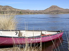
 Boating at Patagonia Lake State Park
|
Patagonia State Park in Arizona |
Location | Santa Cruz, Arizona, United States |
---|
Coordinates | 31°29′38″N 110°51′13″W / 31.49389°N 110.85361°W / 31.49389; -110.85361Coordinates: 31°29′38″N 110°51′13″W / 31.49389°N 110.85361°W / 31.49389; -110.85361
|
---|
Area | 2,658 acres (10.76 km2) |
---|
Elevation | 3,999 ft (1,219 m)[1] |
---|
Established | 1974 |
---|
Governing body | Arizona State Parks |
---|
Patagonia Lake State Park is a state park of Arizona, USA, containing Patagonia Lake. The 2.5-mile-long (4.0 km), 250-acre (100 ha) lake located near Patagonia, Arizona, is a popular southern Arizona site for fishing, camping, boat rental, picnicking, hiking, and birding. Located inside the park is the recently established Sonoita Creek State Natural Area, Arizona's first major state natural area. Created by the damming of Sonoita Creek, the lake is habitat for reproducing largemouth bass, black crappie, bluegill, green sunfish, flathead catfish, threadfin shad, redear sunfish, channel catfish, and American bullfrogs. Rainbow trout are stocked every three weeks from October to March. Sonoita Creek contains black bullhead, red shiner, mosquitofish, crayfish, American bullfrogs, largemouth bass, Gila topminnows, speckled dace, longfin dace, Sonora suckers, and desert suckers.[2] Special events include an annual mariachi festival in March and bird tours and interpretive programs on request.
Patagonia Lake State Park is located on State Route 82, 7 miles (11 km) south of Patagonia, Arizona.
References
^ "Patagonia Lake State Park". Geographic Names Information System. United States Geological Survey. 1984-06-27. Retrieved 2011-03-12..mw-parser-output cite.citationfont-style:inherit.mw-parser-output .citation qquotes:"""""""'""'".mw-parser-output .citation .cs1-lock-free abackground:url("//upload.wikimedia.org/wikipedia/commons/thumb/6/65/Lock-green.svg/9px-Lock-green.svg.png")no-repeat;background-position:right .1em center.mw-parser-output .citation .cs1-lock-limited a,.mw-parser-output .citation .cs1-lock-registration abackground:url("//upload.wikimedia.org/wikipedia/commons/thumb/d/d6/Lock-gray-alt-2.svg/9px-Lock-gray-alt-2.svg.png")no-repeat;background-position:right .1em center.mw-parser-output .citation .cs1-lock-subscription abackground:url("//upload.wikimedia.org/wikipedia/commons/thumb/a/aa/Lock-red-alt-2.svg/9px-Lock-red-alt-2.svg.png")no-repeat;background-position:right .1em center.mw-parser-output .cs1-subscription,.mw-parser-output .cs1-registrationcolor:#555.mw-parser-output .cs1-subscription span,.mw-parser-output .cs1-registration spanborder-bottom:1px dotted;cursor:help.mw-parser-output .cs1-ws-icon abackground:url("//upload.wikimedia.org/wikipedia/commons/thumb/4/4c/Wikisource-logo.svg/12px-Wikisource-logo.svg.png")no-repeat;background-position:right .1em center.mw-parser-output code.cs1-codecolor:inherit;background:inherit;border:inherit;padding:inherit.mw-parser-output .cs1-hidden-errordisplay:none;font-size:100%.mw-parser-output .cs1-visible-errorfont-size:100%.mw-parser-output .cs1-maintdisplay:none;color:#33aa33;margin-left:0.3em.mw-parser-output .cs1-subscription,.mw-parser-output .cs1-registration,.mw-parser-output .cs1-formatfont-size:95%.mw-parser-output .cs1-kern-left,.mw-parser-output .cs1-kern-wl-leftpadding-left:0.2em.mw-parser-output .cs1-kern-right,.mw-parser-output .cs1-kern-wl-rightpadding-right:0.2em
^ https://www.fws.gov/southwest/federal_assistance/pdfs/chapter%2010%20santa%20cruz%20river%20watershed.pdf
External links
 | Wikimedia Commons has media related to Patagonia Lake State Park. |
- Patagonia Lake State Park
Protected areas of Arizona
|
---|
Federal |
National Parks | - Grand Canyon
- Petrified Forest
- Saguaro
|
---|
National Historical Parks, Historic Sites and Memorials | - Tumacácori NHP
- Fort Bowie NHS
- Hubbell Trading Post NHS
- Coronado NMem
|
---|
National Monuments | - National Park Service
- Canyon de Chelly
- Casa Grande Ruins
- Chiricahua
- Hohokam Pima
- Montezuma Castle
- Navajo
- Organ Pipe Cactus
- Pipe Spring
- Sunset Crater
- Tonto
- Tuzigoot
- Walnut Canyon
- Wupatki
- Bureau of Land Management
- Agua Fria
- Grand Canyon-Parashant
- Ironwood Forest
- Sonoran Desert
- Vermilion Cliffs
|
---|
National Conservation Areas | - Gila Box Riparian
- Las Cienegas
- San Pedro Riparian
|
---|
National Recreation Areas | |
---|
National Trails | - Arizona National Scenic Trail
- Juan Bautista de Anza National Historic Trail
- Old Spanish National Historic Trail
|
---|
National Forests | - Apache-Sitgreaves
Coconino
- Elden Pueblo
- Honanki Heritage Site
- Palatki Heritage Site
- V-Bar-V Heritage Site
- Coronado
- Kaibab
- Prescott
- Tonto
|
---|
National Wildlife Refuges | - Bill Williams River
- Buenos Aires
- Cabeza Prieta
- Cibola
- Havasu
- Imperial
- Kofa
- Leslie Canyon
- San Bernardino
|
---|
Wilderness Areas | See List of Arizona Wilderness Areas
|
---|
Wild and Scenic Rivers | |
---|
|
---|
State |
State Parks | - Alamo Lake
- Boyce Thompson Arboretum
- Buckskin Mountain
- Catalina
- Cattail Cove
- Dead Horse Ranch
- Fool Hollow Lake
- Fort Verde
- Granite Mountain Hotshots Memorial
- Homolovi
- Jerome
- Kartchner Caverns
- Lake Havasu
- Lost Dutchman
- Lyman Lake
- McFarland
- Oracle
- Patagonia Lake
- Picacho Peak
- Red Rock
- Riordan Mansion
- River Island
- Roper Lake
- San Rafael
- Slide Rock
- Sonoita Creek
- Tombstone Courthouse
- Tonto Natural Bridge
- Tubac Presidio
- Verde River Greenway
- Yuma Quartermaster Depot
- Yuma Territorial Prison
|
---|
Wildlife areas | - Becker Lake
- Cluff Ranch
- Luna Lake
- Mittry Lake
- Powers Butte
- Santa Rita
- White Mountain Grasslands
- Willcox Playa
|
---|
|
---|
Municipal |
Nature parks | - Phoenix Mountains Park and Recreation Area
- South Mountain Park
- Papago Park
|
---|
|
---|
Other |
National Natural Landmarks | See List of National Natural Landmarks in Arizona
|
---|
National Historic Landmarks | See List of National Historic Landmarks in Arizona
|
---|
Historic Places | See National Register of Historic Places listings in Arizona
|
---|
|
---|
Arizona State Parks (web)
|
DaY9X,gGl7iFhTAjWyoCBEFEtHqEnlb 6USh525fS,2ee2n85g1VbAuoHub5h
這個網誌中的熱門文章
6 I added .AddJsonFile("Connections.json", optional: true, reloadOnChange: true) in public Startup(IHostingEnvironment env) Connections.json contains: "ConnectionStrings": "DefaultConnection": "Server=(localdb)\mssqllocaldb;Database=DATABASE;Trusted_Connection=True;MultipleActiveResultSets=true", "COR-W81-101": "Data Source=DATASOURCE;Initial Catalog=P61_CAFM_Basic;User Id=USERID;Password=PASSWORD;Persist Security Info=False;MultipleActiveResultSets=False;Packet Size=4096;", "COR-W81-100": "Data Source=DATASOURCE;Initial Catalog=Post_PS;User Id=USERID;Password=PASSWORD;Persist Security Info=False;MultipleActiveResultSets=False;Packet Size=4096;", "MSEDGEWIN10": "Data Source=DATASOURCE; Initial Catalog=COR_Basic; Persist Security Info=False;Integrated Security=true;MultipleActiveResultSets=False;Packet Size=4096;Application Name="COR_Basic"", "server...
Chute spillway of Llyn Brianne dam in Wales A spillway is a structure used to provide the controlled release of flows from a dam or levee into a downstream area, typically the riverbed of the dammed river itself. In the United Kingdom, they may be known as overflow channels . Spillways ensure that the water does not overflow and damage or destroy the dam. Floodgates and fuse plugs may be designed into spillways to regulate water flow and reservoir level. Such a spillway can be used to regulate downstream flows – by releasing water in small amounts before the reservoir is full, operators can prevent sudden large releases that would happen if the dam were overtopped. Other uses of the term "spillway" include bypasses of dams or outlets of channels used during high water, and outlet channels carved through natural dams such as moraines. Water normally flows over a spillway only during flood periods – when the reservoir cannot hold the excess of water entering the reservoir ove...
For other uses, see America (disambiguation). The Americas Area 42,549,000 km 2 (16,428,000 sq mi) Population 1,001,559,000 (2016 estimate) Population density 23.5389551 23.53896/km 2 ( 60.965614 60.9656/sq mi) GDP (nominal) $24.6 trillion (2016 estimate) GDP per capita $25,229 (2015) [1] HDI 0.736 [2] Demonym American, [3] New Worlder [4] (see usage) Countries 35 Languages Spanish, English, Portuguese, French, Haitian Creole, Quechua, Guaraní, Aymara, Nahuatl, Dutch and many others Time zones UTC−10:00 to UTC Largest cities Largest metropolitan areas Largest cities List 1.São Paulo 2.Lima 3.Mexico City 4.New York City 5.Bogotá 6.Rio de Janeiro 7.Santiago 8.Los Angeles 9.Caracas 10.Buenos Aires CIA political map of the Americas in Lambert azimuthal equal-area projection The Americas (also collectively called America ; French: Amérique , Spanish/Portuguese: América ) comprise the totality of the continents of North and Sou...