Făgăraș Mountains
| Munții Făgăraș | |
|---|---|
Hungarian: Fogaras hegység | |
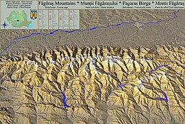 Relief map - Tourist Map | |
| Highest point | |
| Peak | Moldoveanu |
| Elevation | 2,544 m (8,346 ft) |
| Geography | |
| Country | Romania |
| Parent range | Carpathians |
| Geology | |
| Orogeny | Alpine orogeny |
| Age of rock | Mostly Triassic |

Făgăraș Ridge
Făgăraș Mountains (Romanian: Munții Făgărașului [ˈmunt͡sij fəɡəˈraʃuluj] , Hungarian: Fogaras hegység [ˈfoɡɒrɒʃ hɛɟˈʃeːɡ]), are the highest mountains of the Southern Carpathians, in Romania. The highest peaks are:
Moldoveanu 2,544 m
Negoiu 2,535 m
Viștea Mare 2,527 m
Lespezi 2,516 m
Cornul Călțunului 2,510 m
Vânătoarea lui Buteanu 2,507 m
Hârtopul Darei 2,506 m
Dara 2,501 m
Scărișoara Mare 2,495 m
Mușetescu 2,495 m
Capra 2,494 m
Roșu 2,489 m
Negoiu Mic 2,485 m
Podragu 2,482 m
Urlea 2,473 m
They are bordered in the north by the Făgăraș Depression, through which the Olt river flows, and in the west by the Olt Valley (Valea Oltului). Most people wanting to hike on the Moldoveanu leave from the town of Victoria, in other areas Făgăraș Mountains - Arpasu de Jos, Porumbacu de Jos, Avrig. Despite its name, Făgăraș, located 20 km to the north, is not the nearest town to the mountain range. Other important cities are Brașov and Sibiu.[1]
A road called the Transfăgărășan runs across the Făgăraș Mountains. It is generally open only between June and September, due to unfavorable weather conditions in the rest of the year.
You can find many glacier lakes in the Făgăraș Mountains. Bâlea (2034 m, 46,508 m2, 11.35 m deep) is the largest lake. The highest lake is in the Hărtopul Leaotei glacial valley. The deepest glacial lake is Podragu (2140 m, 28,550 m2 15.5 m deep). Other lakes: Urlea (2170 m, 20,150 m2), Capra (2230 m, 18,340 m2).
The Făgăraș Mountains are a very popular hiking, trekking and skiing destination in Romania.
In the vicinity of the Negoiu, and in the central part of the band take the rocky nature of the mountains, and reaching the main ridge trail there are technical difficulties and exposure. Somewhat difficult part of the trail is a "Three steps from the death" running the main ridge by ridge Custura Arpaşului the lake (in Romanian Lacul) Capra (2230 m). Also a bit challenging is one of the ways to Negoiu - Strunga Dracului. The most difficult section of the ridge Custura Sărăţii between Șerbota (2331 m above sea level) and Şaua Cleopatrei pass (2355 m). At the root of the fire is under Șerbota several meters of steel cable handrail, on the other part there are no artificial enhancements.
Contents
1 Location
2 Access
3 Image gallery
4 Notes
5 External links
Location
In the heart of Romania, at 45°35′N 24°45′E / 45.583°N 24.750°E / 45.583; 24.750.

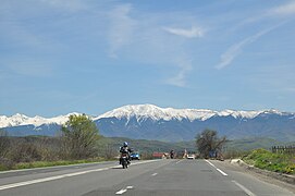
Panoramic view from Sibiu
Access
The most used access points to the mountains are:
- Transfăgărășan, by car
Image gallery
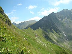
Towards the mountains

View from Sărata

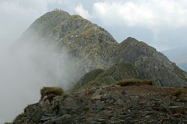
Făgăraș Mountains as viewed from Negoiu

Negoiu Peak (2535m)

Amphitheatre
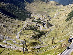
Transfăgărășan road DN7C

Moldoveanu peak and Vistea shelter

Făgăraș Mountains seen from Olt
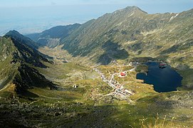
Lake Bâlea

Bâlea caban
Moldoveanu from Vistea Mare peak

Făgăraș Mountains - from above 2000m, towards Moldoveanu Peak (farthest in the image)
Hiking in Făgăraș Mountains
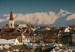
Făgăraș as seen from Sibiu
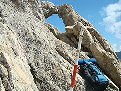
Fereastra Zmeilor rock formations


View towards a glacial valley

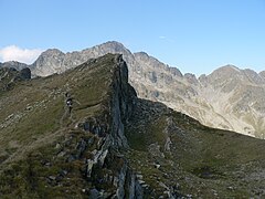
Mountain crests
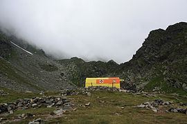
Caltun refuge


Notes
^ Vorhees, M. (2009). Eastern Europe. Lonely Planet. p. 705. ISBN 9781741048544. Retrieved 2015-02-26..mw-parser-output cite.citationfont-style:inherit.mw-parser-output qquotes:"""""""'""'".mw-parser-output code.cs1-codecolor:inherit;background:inherit;border:inherit;padding:inherit.mw-parser-output .cs1-lock-free abackground:url("//upload.wikimedia.org/wikipedia/commons/thumb/6/65/Lock-green.svg/9px-Lock-green.svg.png")no-repeat;background-position:right .1em center.mw-parser-output .cs1-lock-limited a,.mw-parser-output .cs1-lock-registration abackground:url("//upload.wikimedia.org/wikipedia/commons/thumb/d/d6/Lock-gray-alt-2.svg/9px-Lock-gray-alt-2.svg.png")no-repeat;background-position:right .1em center.mw-parser-output .cs1-lock-subscription abackground:url("//upload.wikimedia.org/wikipedia/commons/thumb/a/aa/Lock-red-alt-2.svg/9px-Lock-red-alt-2.svg.png")no-repeat;background-position:right .1em center.mw-parser-output .cs1-subscription,.mw-parser-output .cs1-registrationcolor:#555.mw-parser-output .cs1-subscription span,.mw-parser-output .cs1-registration spanborder-bottom:1px dotted;cursor:help.mw-parser-output .cs1-hidden-errordisplay:none;font-size:100%.mw-parser-output .cs1-visible-errorfont-size:100%.mw-parser-output .cs1-subscription,.mw-parser-output .cs1-registration,.mw-parser-output .cs1-formatfont-size:95%.mw-parser-output .cs1-kern-left,.mw-parser-output .cs1-kern-wl-leftpadding-left:0.2em.mw-parser-output .cs1-kern-right,.mw-parser-output .cs1-kern-wl-rightpadding-right:0.2em
External links
- Fagaras Mountains: Trails, Webcam, Chalets, Cable car, Ski slopes, Transfagarasan, Maps, Alpine Lakes Dam and Lake Vidraru
- Pictures and landscapes from the Fagaras Mountains
- Website about the Carpathian Mountains
- SummitPost Page for Făgăraș
- From Sambata to Vistea refuge in winter
- From Capra to Podragu and Moldoveanu peak in summer
- Piscu Cainelui area in winter
- Fereastra Zmeilor refuge in winter
- Caltun and Scara in winter
- Photos from 25+ trips in the Fagaras range
(in Romanian) (in English) Salvamont Victoria- Fagaras Interactive map
| Wikimedia Commons has media related to Făgăraș Mountains. |
Protected areas of Romania | ||
|---|---|---|
| Biosphere reserves |
|  |
| National parks |
| |
| Nature parks |
| |
| Nature reserves |
| |


