Valdes Peninsula
| UNESCO World Heritage site | |
|---|---|
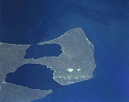 Peninsula Valdés, photo taken during Space Shuttle program STS-68. | |
| Location | Biedma Department, Chubut Province, Argentina |
| Criteria | Natural: (x) |
| Reference | 937 |
| Inscription | 1999 (23rd Session) |
| Area | 360,000 ha (890,000 acres) |
| Website | peninsulavaldes.org.ar |
| Coordinates | 42°30′S 64°0′W / 42.500°S 64.000°W / -42.500; -64.000Coordinates: 42°30′S 64°0′W / 42.500°S 64.000°W / -42.500; -64.000 |
Ramsar Wetland | |
| Official name | Humedales de Península Valdés |
| Designated | 20 July 2012 |
| Reference no. | 2070[1] |
 Location of Valdes Peninsula in Chubut Province Show map of Chubut Province 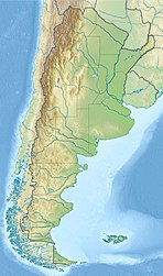 Valdes Peninsula (Argentina) Show map of Argentina | |
The Valdes Peninsula (Spanish: Península Valdés) is a peninsula into the Atlantic Ocean in the Biedma Department of north-east Chubut Province, Argentina. Around 3,625 km2 (896,000 acres; 1,400 sq mi) in size (not taking into account the isthmus of Carlos Ameghino which connects the peninsula to the mainland), it is an important nature reserve which was listed as a World Heritage Site by UNESCO in 1999.
Contents
1 Geography
2 Fauna
3 Climate
4 References
5 External links
Geography
The nearest large town is Puerto Madryn. The only town on the peninsula is the small settlement of Puerto Pirámides. There are also a number of estancias, where sheep are raised.
Most of the peninsula is barren land with some salt lakes. The largest of these lakes is at an elevation of about 40 m below sea level (see extremes on Earth), until recently thought to be the lowest elevation in Argentina and South America (the lowest point actually being Laguna del Carbón, Argentina).
Fauna
The coastline is inhabited by marine mammals, like sea lions, elephant seals and fur seals. Southern right whales can be found in Golfo Nuevo and Golfo San José, protected bodies of water located between the peninsula and the Patagonian mainland. These baleen whales come here between May and December, for mating and giving birth, because the water in the gulf is quieter and warmer than in the open sea. Orcas can be found off the coast, in the open sea off the peninsula. In this area, they are known to beach themselves on shore to capture sea lions and elephant seals.
The inner part of the peninsula is inhabited by rheas, guanacos and maras. A high diversity and range of birds live in the peninsula as well; at least 181 bird species, 66 of which migratory, live in the area, including the Antarctic pigeon.
.mw-parser-output .mod-gallerydisplay:table.mw-parser-output .mod-gallery-defaultbackground:transparent;margin-top:0.5em.mw-parser-output .mod-gallery-centermargin-left:auto;margin-right:auto.mw-parser-output .mod-gallery-leftfloat:left.mw-parser-output .mod-gallery-rightfloat:right.mw-parser-output .mod-gallery-nonefloat:none.mw-parser-output .mod-gallery-collapsiblewidth:100%.mw-parser-output .mod-gallery .titledisplay:table-row.mw-parser-output .mod-gallery .title>divdisplay:table-cell;text-align:center;font-weight:bold.mw-parser-output .mod-gallery .maindisplay:table-row.mw-parser-output .mod-gallery .main>divdisplay:table-cell.mw-parser-output .mod-gallery .captiondisplay:table-row;vertical-align:top.mw-parser-output .mod-gallery .caption>divdisplay:table-cell;display:block;font-size:94%;padding:0.mw-parser-output .mod-gallery .footerdisplay:table-row.mw-parser-output .mod-gallery .footer>divdisplay:table-cell;text-align:right;font-size:80%;line-height:1em.mw-parser-output .mod-gallery .gallerybox .thumb imgbackground:none.mw-parser-output .mod-gallery .bordered-images imgborder:solid #eee 1px

Whale watching

Whale underwater off the peninsula

Whale in Valdes Peninsula

Magellanic penguins

Pichi

Wild guanaco
Argentine grey fox

Southern elephant seals
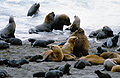
South American sea lions


Climate
Valdes Peninsula has a semi-arid climate.[2] It has a climate typical of northern Patagonia that is modified with interactions between atmospheric circulation patterns and the adjacent ocean.[3][4] The peninsula is located between the subtropical high pressure belt (located at 30oS) and the subpolar low pressure zone (located between 60o–70oS), resulting in the wind being predominantly from the west.[2][4] The mean annual temperature is 10.6 °C (51.1 °F),[2] ranging from a mean monthly temperature of 8 °C (46.4 °F) in winter to 18 °C (64.4 °F) in summer.[4] During winter, temperatures fluctuate between 0 to 15 °C (32.0 to 59.0 °F) with frosts being common, averaging 12–20 days during the season.[2] Temperatures in the summer can fluctuate between 15 to 35 °C (59.0 to 95.0 °F).[2]
Mean annual precipitation is low, averaging 240 mm (9.4 in) although this is highly variable from year to year.[2] The interior of the peninsula receives slightly lower precipitation than the coastal areas, receiving 200 to 225 mm (7.9 to 8.9 in) per year.[3] Precipitation is fairly evenly distributed throughout the year though April–June receives the most precipitation.[4][3] The El Niño Southern Oscillation strongly influences the climate of the peninsula.[4] During an El Niño year, precipitation is higher from November to February.[4]
| Climate data for Punta Delgada Lighthouse, Valdes Peninsula | |||||||||||||
|---|---|---|---|---|---|---|---|---|---|---|---|---|---|
| Month | Jan | Feb | Mar | Apr | May | Jun | Jul | Aug | Sep | Oct | Nov | Dec | Year |
| Record high °C (°F) | 35.9 (96.6) | 35.6 (96.1) | 34.9 (94.8) | 30.1 (86.2) | 24.5 (76.1) | 20.9 (69.6) | 17.9 (64.2) | 21.9 (71.4) | 26.9 (80.4) | 30.4 (86.7) | 34.9 (94.8) | 37.2 (99) | 37.2 (99) |
| Average high °C (°F) | 22.8 (73) | 23.2 (73.8) | 21.1 (70) | 18.6 (65.5) | 14.6 (58.3) | 12.2 (54) | 11.2 (52.2) | 11.6 (52.9) | 13.7 (56.7) | 17.2 (63) | 19.4 (66.9) | 21.8 (71.2) | 17.3 (63.1) |
| Daily mean °C (°F) | 17.4 (63.3) | 17.6 (63.7) | 16.1 (61) | 13.7 (56.7) | 10.8 (51.4) | 8.2 (46.8) | 7.1 (44.8) | 7.7 (45.9) | 9.2 (48.6) | 11.5 (52.7) | 13.8 (56.8) | 15.7 (60.3) | 12.4 (54.3) |
| Average low °C (°F) | 13.1 (55.6) | 13.3 (55.9) | 12.0 (53.6) | 10.2 (50.4) | 7.0 (44.6) | 4.3 (39.7) | 3.6 (38.5) | 3.2 (37.8) | 5.5 (41.9) | 7.4 (45.3) | 9.8 (49.6) | 12.0 (53.6) | 8.5 (47.3) |
| Record low °C (°F) | 5.1 (41.2) | 5.4 (41.7) | 4.3 (39.7) | 0.3 (32.5) | −0.1 (31.8) | −3.4 (25.9) | −3.5 (25.7) | −2.9 (26.8) | −4.9 (23.2) | −2.4 (27.7) | 1.6 (34.9) | 2.7 (36.9) | −4.9 (23.2) |
| Average precipitation mm (inches) | 13.9 (0.547) | 10.5 (0.413) | 23.5 (0.925) | 25.9 (1.02) | 25.0 (0.984) | 25.2 (0.992) | 27.9 (1.098) | 14.8 (0.583) | 16.5 (0.65) | 12.1 (0.476) | 13.1 (0.516) | 15.1 (0.594) | 223.5 (8.799) |
| Average relative humidity (%) | 68.0 | 68.5 | 68.5 | 68.5 | 72.5 | 76.5 | 77.0 | 72.5 | 72.5 | 68.0 | 69.0 | 67.5 | 70.8 |
| Source: Secretaria de Mineria[5] | |||||||||||||
References
^ "Humedales de Península Valdés". Ramsar Sites Information Service. Retrieved 25 April 2018..mw-parser-output cite.citationfont-style:inherit.mw-parser-output qquotes:"""""""'""'".mw-parser-output code.cs1-codecolor:inherit;background:inherit;border:inherit;padding:inherit.mw-parser-output .cs1-lock-free abackground:url("//upload.wikimedia.org/wikipedia/commons/thumb/6/65/Lock-green.svg/9px-Lock-green.svg.png")no-repeat;background-position:right .1em center.mw-parser-output .cs1-lock-limited a,.mw-parser-output .cs1-lock-registration abackground:url("//upload.wikimedia.org/wikipedia/commons/thumb/d/d6/Lock-gray-alt-2.svg/9px-Lock-gray-alt-2.svg.png")no-repeat;background-position:right .1em center.mw-parser-output .cs1-lock-subscription abackground:url("//upload.wikimedia.org/wikipedia/commons/thumb/a/aa/Lock-red-alt-2.svg/9px-Lock-red-alt-2.svg.png")no-repeat;background-position:right .1em center.mw-parser-output .cs1-subscription,.mw-parser-output .cs1-registrationcolor:#555.mw-parser-output .cs1-subscription span,.mw-parser-output .cs1-registration spanborder-bottom:1px dotted;cursor:help.mw-parser-output .cs1-hidden-errordisplay:none;font-size:100%.mw-parser-output .cs1-visible-errorfont-size:100%.mw-parser-output .cs1-subscription,.mw-parser-output .cs1-registration,.mw-parser-output .cs1-formatfont-size:95%.mw-parser-output .cs1-kern-left,.mw-parser-output .cs1-kern-wl-leftpadding-left:0.2em.mw-parser-output .cs1-kern-right,.mw-parser-output .cs1-kern-wl-rightpadding-right:0.2em
^ abcdef "Ficha Informativa de los Humedales de Ramsar (FIR) – Versión 2009-2012" (PDF) (in Spanish). Secretaría de Ambiente y Desarrollo Sustentable. Archived (PDF) from the original on 21 March 2016. Retrieved 10 October 2015.
^ abc "Location and Climate". Municipio de Puerto Pirámides. Retrieved October 10, 2015.
^ abcdef "Capítulo I: Caracterización y Antecedentes" (PDF). Plan de Manejo del Sistema Península Valdés (in Spanish). Administración Area Natural Protegida Península Valdés. Archived (PDF) from the original on 29 April 2018. Retrieved 10 October 2015.
^ "Provincia de Chubut - Clima Y Meteorologia: Datos Meteorologicos Y Pluviometicos" (in Spanish). Secretaria de Mineria de la Nacion (Argentina). Archived from the original on January 19, 2015. Retrieved August 20, 2015.
External links
| Wikimedia Commons has media related to Valdes Peninsula. |
"Chile - Argentina 2000: Peninsula Valdez". caracara.org. 2000. Retrieved 1 February 2010.
"El Portal de Puerto Pirámides (Puerto Pirámides' official page)" (in Spanish). Retrieved 1 February 2010.
"Punta Norte Orca Research". Retrieved 1 February 2010. (Orca Conservation group at the Peninsula Valdes)
World Heritage Sites in Argentina | ||
|---|---|---|
| Northwest |
| |
| Mesopotamia |
| |
| Cuyo |
| |
| Pampas |
| |
| Patagonia |
| |
| ||


