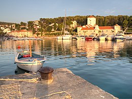
Šolta
 Šolta | |
 | |
| Geography | |
|---|---|
| Location | Adriatic Sea |
| Coordinates | 43°22′N 16°19′E / 43.37°N 16.31°E / 43.37; 16.31Coordinates: 43°22′N 16°19′E / 43.37°N 16.31°E / 43.37; 16.31 |
| Area | 58.98 km2 (22.77 sq mi) |
| Highest elevation | 238 m (781 ft) |
| Highest point | Vela Straža |
| Administration | |
Croatia | |
| County | Split-Dalmatia |
| Demographics | |
| Population | 1,700[1] (2011) |
| Pop. density | 28 /km2 (73 /sq mi) |
Šolta (pronounced [ʃɔ̂ːlta]; Italian: Solta; Latin: Solentium) is an island in Croatia. It is situated in the Adriatic Sea in the central Dalmatian archipelago, west of the island of Brač, south of Split (separated by Split Channel) and east of the Drvenik islands, Drvenik Mali and Drvenik Veli (separated by the Šolta Channel).[2] Its area is 58.98 km2[3][4] and it has a population of 1,700 (as of 2011[update]).[1]
The highest peak of Šolta is the summit Vela Straža[5] which is 236 metres high.[4] On the north-eastern coast of the island there are the large bays of Rogač and Nečujam. In the western part of the interior of Šolta there is a field approximately 6 km (4 mi) long and 2 km (1 mi) wide.

Satellite image of Šolta
The economy of the island is based on vineyards, olives, fruit, fishing and tourism.[2][5] While the main settlements (Grohote, Gornje Selo, Srednje Selo, Donje Selo) are inland, the main fishing centres are Maslinica,[5] which is exposed to only north-westerly winds, making it a good shelter for smaller boats.[2]Rogač is the main port and Nečujam the centre of the island’s tourism.
Image gallery
- Šolta

Old lane in Grohote

Gornje Selo

Port of Maslinica

Nečujam

Bunja in Nečujam
References
^ ab "Population by Age and Sex, by Settlements, 2011 Census: Šolta". Census of Population, Households and Dwellings 2011. Zagreb: Croatian Bureau of Statistics. December 2012..mw-parser-output cite.citationfont-style:inherit.mw-parser-output .citation qquotes:"""""""'""'".mw-parser-output .citation .cs1-lock-free abackground:url("//upload.wikimedia.org/wikipedia/commons/thumb/6/65/Lock-green.svg/9px-Lock-green.svg.png")no-repeat;background-position:right .1em center.mw-parser-output .citation .cs1-lock-limited a,.mw-parser-output .citation .cs1-lock-registration abackground:url("//upload.wikimedia.org/wikipedia/commons/thumb/d/d6/Lock-gray-alt-2.svg/9px-Lock-gray-alt-2.svg.png")no-repeat;background-position:right .1em center.mw-parser-output .citation .cs1-lock-subscription abackground:url("//upload.wikimedia.org/wikipedia/commons/thumb/a/aa/Lock-red-alt-2.svg/9px-Lock-red-alt-2.svg.png")no-repeat;background-position:right .1em center.mw-parser-output .cs1-subscription,.mw-parser-output .cs1-registrationcolor:#555.mw-parser-output .cs1-subscription span,.mw-parser-output .cs1-registration spanborder-bottom:1px dotted;cursor:help.mw-parser-output .cs1-ws-icon abackground:url("//upload.wikimedia.org/wikipedia/commons/thumb/4/4c/Wikisource-logo.svg/12px-Wikisource-logo.svg.png")no-repeat;background-position:right .1em center.mw-parser-output code.cs1-codecolor:inherit;background:inherit;border:inherit;padding:inherit.mw-parser-output .cs1-hidden-errordisplay:none;font-size:100%.mw-parser-output .cs1-visible-errorfont-size:100%.mw-parser-output .cs1-maintdisplay:none;color:#33aa33;margin-left:0.3em.mw-parser-output .cs1-subscription,.mw-parser-output .cs1-registration,.mw-parser-output .cs1-formatfont-size:95%.mw-parser-output .cs1-kern-left,.mw-parser-output .cs1-kern-wl-leftpadding-left:0.2em.mw-parser-output .cs1-kern-right,.mw-parser-output .cs1-kern-wl-rightpadding-right:0.2em
^ abc Šolta on Kroatien-online.com
^
Duplančić Leder, Tea; Ujević, Tin; Čala, Mendi (June 2004). "Coastline lengths and areas of islands in the Croatian part of the Adriatic Sea determined from the topographic maps at the scale of 1 : 25 000" (PDF). Geoadria. Zadar. 9 (1): 5–32. Retrieved 2011-01-21.
^ ab Ostroški, Ljiljana, ed. (December 2015). Statistički ljetopis Republike Hrvatske 2015 [Statistical Yearbook of the Republic of Croatia 2015] (PDF). Statistical Yearbook of the Republic of Croatia (in Croatian and English). 47. Zagreb: Croatian Bureau of Statistics. p. 47. ISSN 1333-3305. Retrieved 27 December 2015.
^ abc "Šolta". General Encyclopedia of the Yugoslav Lexicographical Institute (in Croatian). 8. Zagreb: Yugoslav Lexicographical Institute. 1982.
External links
| Wikimedia Commons has media related to Šolta. |
- Report about Šolta
- Tourist office of island Šolta
- Official page of Šolta
- Forum of Šolta


