County in Alborz, Iran
Savojbolagh County
شهرستان ساوجبلاغ
|
|---|
County |
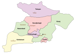 Location in Alborz Province
|
 Location of Alborz Province in Iran
|
| Country |
 Iran Iran
|
|---|
| Province |
Alborz |
|---|
| Capital |
Hashtgerd |
|---|
Bakhsh (Districts) |
Central District, Chaharbagh District, Chendar District
|
|---|
| Population (2017)
|
|---|
| • Total |
260,000 |
|---|
| Time zone |
UTC+3:30 (IRST) |
|---|
| • Summer (DST) |
UTC+4:30 (IRDT) |
|---|
Savojbolagh County (Persian: شهرستان ساوجبلاغ) is a county in Alborz Province in Iran. The capital of the county is Hashtgerd. At the 2017 census, the county's population (including those portions later split off to form Taleqan County) was 260,345in 59,935 families. The county is subdivided into three districts: the Central District, Chaharbagh District, and Chendar District. The county has five cities: Hashtgerd, Chaharbagh, Golsar, Kuhsar, and Shahr-e Jadid-e Hashtgerd.
References
- اطلس گیتاشناسی استانهای ایران [Atlas Gitashenasi Ostanhai Iran] (Gitashenasi Province Atlas of Iran)
External links
 |
Wikimedia Commons has media related to Savojbolagh County. |
Alborz Province
|
|---|
| Capital |
|
|
|---|
Counties and cities
|
| Eshtehard County |
|
|---|
| Fardis County |
- Fardis
- Farrokhabad
- Meshkinabad
- Vahdat
|
|---|
| Karaj County |
- Karaj
- Asara
- Garmdarreh
- Kamal Shahr
- Mahdasht
- Meshkin Dasht
- Mohammadshahr
|
|---|
| Nazarabad County |
|
|---|
| Savojbolagh County |
- Hashtgerd
- Chaharbagh
- Golsar
- Kuhsar
- Shahr-e Jadid-e Hashtgerd
|
|---|
| Taleqan County |
|
|---|
|
|---|
| Sights |
- Ahmadabad-e Mosaddeq
- Shahabbasi caravansary
- Pearl Palace
|
|---|
| populated places |
- List of cities, towns and villages in Alborz Province
|
|---|
Savojbolagh County
|
|---|
| Capital |
|
|---|
| Districts |
| Central |
| Cities |
- Hashtgerd
- Golsar
- Shahr-e Jadid-e Hashtgerd
|
|---|
Rural Districts
and villages |
| Hiv |
- Arababad
- Hiv
- Khur
- Sefidarak
- Shalamzar
|
|---|
| Saidabad |
- Abbasabad-e Bozorg
- Abbasabad-e Kuchek
- Ahmadabad-e Etemad ol Dowleh
- Aran
- Derakhshaniyeh
- Esmailabad
- Eyqer Bolagh
- Hoseynabad-e Kushk Zar
- Kargalin
- Masudiyeh
- Namak Alan
- Qasemabad-e Aqa
- Qasemabad-e Bozorg
- Rezaabad-e Sufian
- Saidabad
- Sherkat-e Chanieh
- Soltanabad-e Aran
- Sorkhab
- Yengi Emam
|
|---|
|
|---|
|
|---|
| Chaharbagh |
| Cities |
|
|---|
Rural Districts
and villages |
| Chahardangeh |
- Aqdasiyeh
- Arababad-e Khosravi
- Bagh-e Naseri
- Bi Sim-e Kamalabad
- Devaslah Friendship Seed Company
- Esmailabad Shur Qaleh-ye Bala
- Esmailabad Shur Qaleh-ye Pain
- Hakimiyeh
- Kuy-e Behrooz
- Kuy-e Raz
- Malekabad-e Hammanlu
- Mehdiabad
- Quheh
- Shahrak-e Elahiyeh
- Soltanabad
|
|---|
| Ramjin |
- Aghcheh Hesar
- Bagh-e Chaveshi
- Dehkadeh-ye Taleqani
- Ebrahimabad
- Kahrizak
- Kheyrabad
- Lashkarabad
- Mazraeh-ye Hamidieh
- Mazraeh-ye Soheylieh
- Mohammadabad-e Afshar
- Morghak-e Yek
- Oghlan Tappeh
- Qasemabad-e Gorji
- Ramjin
- Rundeh
- Shahrak-e Afshariyeh
- Sonqorabad
- Tavusiyeh
- Yaqubabad
- Zafaraniyeh
- Zakiabad
|
|---|
|
|---|
|
|---|
| Chendar |
| Cities |
|
|---|
Rural Districts
and villages |
| Baraghan |
- Aghasht
- Alaqeband
- Aminabad
- Baghban Kalachi
- Baraghan
- Beryanchal
- Chalengdar
- Hasanabad
- Sanj
- Siah Karan
- Sibandarreh
- Sorheh
- Talian
- Tekyeh Aghasht
- Vamkuh
- Vardeh
|
|---|
| Chendar |
- Ajin Dojin
- Ardaheh
- Askul Darreh
- Aznaq
- Banu Sahra
- Duz Anbar
- Emamzadeh Shahzadeh Hoseyn
- Fashand
- Harjab
- Kalinrud
- Khurvin
- Kolaleh Chin
- Kordan
- Kushk-e Zar
- Mazraeh-ye Gazal Darreh
- Mazraeh-ye Hasanabad
- Sefid Aran
- Shendeh
- Sibestan
- Sirud
- Valian
- Voshkin
|
|---|
|
|---|
|
|---|
|
|---|
Coordinates: 35°57′N 50°40′E / 35.950°N 50.667°E / 35.950; 50.667


