Lucky Peak Dam
| Lucky Peak Dam | |
|---|---|
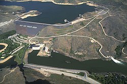 aerial view in June 1997 | |
 Location in southwest Idaho Show map of Idaho  Lucky Peak Dam (the United States) Show map of the United States | |
| Country | United States |
| Location | Ada County, Idaho |
| Coordinates | 43°31′42″N 116°3′11″W / 43.52833°N 116.05306°W / 43.52833; -116.05306Coordinates: 43°31′42″N 116°3′11″W / 43.52833°N 116.05306°W / 43.52833; -116.05306[1] |
| Purpose | Flood control, irrigation |
| Construction began | 1949 (1949) |
| Opening date | 1955 (1955) [2] |
| Construction cost | $19 million (1955) |
| Owner(s) | U.S. Army Corps of Engineers [2] |
| Dam and spillways | |
| Type of dam | Embankment dam |
| Impounds | Boise River |
| Height | 340 ft (104 m) [2] |
| Length | 2,340 ft (713 m) [2] |
| Reservoir | |
| Creates | Lucky Peak Reservoir |
| Total capacity | 307,000 acre feet (379,000,000 m3) [2] |
| Catchment area | 2,680 square miles (6,940 km2) [2] |
| Surface area | 2,820 acres (11.4 km2) [2] |
| Normal elevation | 3,050 ft (930 m) |
| Power Station | |
| Commission date | 1988 (1988) |
| Turbines | 2 x 45 MW, 1 x 11 MW Kaplan-type [3][4] |
| Installed capacity | 101 MW |
| Annual generation | 321,790,000 KWh |
Lucky Peak Dam is a rolled earth and gravel fill embankment dam in the western United States, located on the Boise River in Ada County, Idaho. It is directly downstream of Arrowrock Dam, a concrete arch dam completed in 1915. At the time of its construction in the early 1950s, Lucky Peak's primary purpose was flood control, with a secondary purpose of irrigation.[2] The normal operating elevation of the full reservoir is 3,055 feet (931 m) above sea level, the empty reservoir's elevation (Boise River) is 2,824 feet (861 m).[5]
Construction began in November 1949 by the U.S. Army Corps of Engineers; the dam was operational in 1955 and its resulting reservoir is Lucky Peak Lake. Most of the federal dams in southern Idaho, including the others on the Boise River, were built by the Bureau of Reclamation, not the Corps of Engineers. The Idaho Power Company, a private utility, built multiple hydroelectric dams on the Snake River.
Located along State Highway 21, ten miles (16 km) upstream from the city of Boise, it was built without hydroelectric power generation. Construction of the powerhouse began in 1984 and it became operational in 1988, generating electricity primarily for Seattle City Light.[6]
The dam was named after a nearby mountain in the Boise Range, about four miles (6 km) north of the dam (43°36′18″N 116°03′43″W / 43.605°N 116.062°W / 43.605; -116.062). The summit elevation of Lucky Peak mountain (a.k.a. Shaw Mountain) is 5,904 feet (1,800 m).[7]
The dam forms Lucky Peak Lake and is surrounded by Lucky Peak State Park.
Clifford Riddle was brought in after numerous unsuccessful blasting attempts to drive a road through the pass (and loss of lives). The road which now leads up through Lucky Peak and into the dam is due to his successful efforts.
Gallery
Lucky Peak Dam
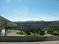
Lucky Peak Lake from Idaho highway 21

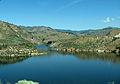
Lucky Peak Lake in April 2010


References
^ U.S. Geological Survey Geographic Names Information System: Lucky Peak Dam
^ abcdefgh Lucky Peak Dam Archived 2011-07-16 at the Wayback Machine, NPDP Dam Directory
^ "Service Projects Summary". AEHydro. Retrieved 29 July 2011..mw-parser-output cite.citationfont-style:inherit.mw-parser-output .citation qquotes:"""""""'""'".mw-parser-output .citation .cs1-lock-free abackground:url("//upload.wikimedia.org/wikipedia/commons/thumb/6/65/Lock-green.svg/9px-Lock-green.svg.png")no-repeat;background-position:right .1em center.mw-parser-output .citation .cs1-lock-limited a,.mw-parser-output .citation .cs1-lock-registration abackground:url("//upload.wikimedia.org/wikipedia/commons/thumb/d/d6/Lock-gray-alt-2.svg/9px-Lock-gray-alt-2.svg.png")no-repeat;background-position:right .1em center.mw-parser-output .citation .cs1-lock-subscription abackground:url("//upload.wikimedia.org/wikipedia/commons/thumb/a/aa/Lock-red-alt-2.svg/9px-Lock-red-alt-2.svg.png")no-repeat;background-position:right .1em center.mw-parser-output .cs1-subscription,.mw-parser-output .cs1-registrationcolor:#555.mw-parser-output .cs1-subscription span,.mw-parser-output .cs1-registration spanborder-bottom:1px dotted;cursor:help.mw-parser-output .cs1-ws-icon abackground:url("//upload.wikimedia.org/wikipedia/commons/thumb/4/4c/Wikisource-logo.svg/12px-Wikisource-logo.svg.png")no-repeat;background-position:right .1em center.mw-parser-output code.cs1-codecolor:inherit;background:inherit;border:inherit;padding:inherit.mw-parser-output .cs1-hidden-errordisplay:none;font-size:100%.mw-parser-output .cs1-visible-errorfont-size:100%.mw-parser-output .cs1-maintdisplay:none;color:#33aa33;margin-left:0.3em.mw-parser-output .cs1-subscription,.mw-parser-output .cs1-registration,.mw-parser-output .cs1-formatfont-size:95%.mw-parser-output .cs1-kern-left,.mw-parser-output .cs1-kern-wl-leftpadding-left:0.2em.mw-parser-output .cs1-kern-right,.mw-parser-output .cs1-kern-wl-rightpadding-right:0.2em
^ "Hydropower". Barker Rosholt & Simpson, LLP. Archived from the original on 9 December 2012. Retrieved 29 July 2011.CS1 maint: BOT: original-url status unknown (link)
^ USACE - Lucky Peak - Pertinent Data Archived 2009-06-18 at the Wayback Machine
^ USACE - Lucky Peak Reservoir Archived 2009-06-18 at the Wayback Machine
^ "Lucky Peak". idahoalpinezone.com. Retrieved May 5, 2012.
External links
@media all and (max-width:720px).mw-parser-output .mobile-float-resetfloat:none!important;width:100%!important.mw-parser-output .stack-containerbox-sizing:border-box.mw-parser-output .stack-clear-leftfloat:left;clear:left.mw-parser-output .stack-clear-rightfloat:right;clear:right.mw-parser-output .stack-leftfloat:left.mw-parser-output .stack-rightfloat:right.mw-parser-output .stack-objectmargin:1px;overflow:hidden
U.S. Army Corps of Engineers - Lucky Peak Dam & Lake
U.S. Bureau of Reclamation - Idaho facilities
Seattle City Light - a brief history
Bureau of Reclamation - major storage reservoirs in the Boise & Payette River basins - current levels & flows

