Lanzarote
Native name: "Lanzarote" Nickname: "Lanza" | |
|---|---|
 Flag of Lanzarote | |
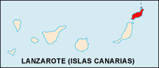 | |
 Lanzarote Show map of Canary Islands 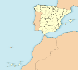 Lanzarote Show map of Spain, Canary Islands | |
| Geography | |
| Location | Atlantic Ocean |
| Coordinates | 29°02′06″N 13°37′59″W / 29.035°N 13.633°W / 29.035; -13.633Coordinates: 29°02′06″N 13°37′59″W / 29.035°N 13.633°W / 29.035; -13.633 |
| Archipelago | Canary Islands |
| Area | 845.9 km2 (326.6 sq mi) |
| Highest elevation | 671 m (2,201 ft) |
| Highest point | Peñas del Chache |
| Administration | |
Spain | |
| Autonomous community | Canary Islands |
| Province | Las Palmas |
| Largest settlement | Arrecife (pop. 55,203) |
| Demographics | |
| Population | 149,183 (2018) |
| Pop. density | 227,6 /km2 (5,895 /sq mi) |
| Ethnic groups | Spanish, other minority groups |
Lanzarote (/ˌlænzəˈrɒti/; Spanish pronunciation: [lanθaˈɾote, lansaˈɾote]) is a Spanish island, the northernmost and easternmost of the autonomous Canary Islands in the Atlantic Ocean. It is located approximately 125 kilometres (78 miles) off the north coast of Africa and 1,000 kilometres (621 miles) from the Iberian Peninsula. Covering 845.94 square kilometres (326.62 square miles), Lanzarote is the fourth-largest of the islands in the archipelago. With 149,183 inhabitants,[1] it is the third-most populous Canary Island, after Tenerife and Gran Canaria. In the centre-west of the island is Timanfaya National Park, one of its main attractions. The capital is Arrecife.
The first recorded name for the island, given by Italian-Majorcan cartographer Angelino Dulcert, was Insula de Lanzarotus Marocelus, after the Genoese navigator Lancelotto Malocello, from which the modern name is derived. The island's name in the native language was Tyterogaka or Tytheroygaka, which may mean "one that is all ochre" (referring to the island's predominant colour).[2]
Contents
1 Geography
2 Climate
3 Geology
4 Demographics
5 Biodiversity
5.1 Plants
5.2 Fungi
5.3 Animals
6 Natural symbols
7 History
8 Notable people
9 Festivals
10 Gallery
11 References
12 Further reading
13 External links
Geography
Lanzarote is located 11 kilometres (7 miles) north-east of Fuerteventura and just over 1 kilometre (0.62 miles) from Graciosa. The dimensions of the island are 60 kilometres (37 miles) from north to south and 25 kilometres (16 miles) from west to east. Lanzarote has 213 kilometres (132 miles) of coastline, of which 10 kilometres (6 miles) are sand, 16.5 kilometres (10 miles) are beach, and the remainder is rocky. Its landscape includes the mountain ranges of Famara (671 metres or 2,201 feet)[3] in the north and Ajaches (608 metres or 1,995 feet) to the south. South of the Famara massif is the El Jable desert, which separates Famara and Montañas del Fuego. The highest peak is Peñas del Chache, rising to 670 metres (2,200 feet) above sea level. The "Tunnel of Atlantis", the largest underwater volcanic tunnel in the world, is part of the Cueva de los Verdes lava tube.[4]
Climate
Often called the "Island of Eternal Spring",[5] Lanzarote has a subtropical-desert climate according to the Köppen climatic classification.[6] The small amount of precipitation is mainly concentrated in the winter. Rainfall during summer is a rare phenomenon and several summers are completely dry without any precipitation. On average the island receives approximately 16 days of precipitation between December and February.[5] Sometimes, the hot sirocco wind prevails, causing dry and dusty conditions across the island.[5] Average precipitation in June and August is less than 0.5 millimetres (0.020 inches). It closely borders on a tropical climate, with winter means of 18 °C (64 °F) and summer means of 25 °C (77 °F).
| Climate data for Lanzarote Airport (1981–2010) | |||||||||||||
|---|---|---|---|---|---|---|---|---|---|---|---|---|---|
| Month | Jan | Feb | Mar | Apr | May | Jun | Jul | Aug | Sep | Oct | Nov | Dec | Year |
| Record high °C (°F) | 27.9 (82.2) | 29.0 (84.2) | 32.7 (90.9) | 36.3 (97.3) | 42.6 (108.7) | 40.7 (105.3) | 42.9 (109.2) | 43.6 (110.5) | 40.5 (104.9) | 37.1 (98.8) | 34.2 (93.6) | 27.5 (81.5) | 43.6 (110.5) |
| Average high °C (°F) | 20.7 (69.3) | 21.3 (70.3) | 22.9 (73.2) | 23.5 (74.3) | 24.6 (76.3) | 26.3 (79.3) | 28.2 (82.8) | 29.1 (84.4) | 28.6 (83.5) | 26.7 (80.1) | 24.2 (75.6) | 21.8 (71.2) | 24.8 (76.6) |
| Daily mean °C (°F) | 17.4 (63.3) | 17.9 (64.2) | 19.0 (66.2) | 19.6 (67.3) | 20.8 (69.4) | 22.6 (72.7) | 24.3 (75.7) | 25.2 (77.4) | 24.7 (76.5) | 23.0 (73.4) | 20.7 (69.3) | 18.6 (65.5) | 21.1 (70.0) |
| Average low °C (°F) | 14.0 (57.2) | 14.3 (57.7) | 15.0 (59.0) | 15.7 (60.3) | 16.8 (62.2) | 18.8 (65.8) | 20.4 (68.7) | 21.2 (70.2) | 20.8 (69.4) | 19.4 (66.9) | 17.2 (63.0) | 15.4 (59.7) | 17.4 (63.3) |
| Record low °C (°F) | 8.0 (46.4) | 9.0 (48.2) | 8.3 (46.9) | 9.5 (49.1) | 11.5 (52.7) | 12.4 (54.3) | 15.4 (59.7) | 16.6 (61.9) | 15.5 (59.9) | 12.0 (53.6) | 10.9 (51.6) | 9.0 (48.2) | 8.0 (46.4) |
| Average rainfall mm (inches) | 16.5 (0.65) | 18.2 (0.72) | 12.5 (0.49) | 5.2 (0.20) | 1.5 (0.06) | 0.1 (0.00) | 0.0 (0.0) | 0.5 (0.02) | 2.2 (0.09) | 9.9 (0.39) | 14.7 (0.58) | 29.3 (1.15) | 110.6 (4.35) |
| Average rainy days (≥ 1.0 mm) | 3 | 3 | 2 | 1 | 0 | 0 | 0 | 0 | 0 | 2 | 3 | 4 | 18 |
| Average relative humidity (%) | 68 | 68 | 66 | 66 | 66 | 66 | 68 | 68 | 70 | 71 | 69 | 71 | 68 |
| Mean monthly sunshine hours | 203 | 201 | 241 | 255 | 297 | 292 | 308 | 295 | 248 | 235 | 207 | 196 | 2,978 |
| Source: Agencia Estatal de Meteorología[7] | |||||||||||||
Geology

Atlantic Ocean at Los Picollos, Lanzarote
Lanzarote is the northernmost and easternmost island of the Canary Islands and has a volcanic origin. It was born through fiery eruptions and has solidified lava streams as well as extravagant rock formations. The island emerged about 15 million years ago as product of the Canary hotspot. The island, along with others, emerged after the breakup of the African and the American continental plates. The greatest recorded eruptions occurred between 1730 and 1736 in the area now designated Timanfaya National Park.[8]
Demographics

Papagayo Beach
As of 2018[update], 149,183 people live on Lanzarote,[9] an increase of 9.4% from 2006 (127,000).[10] The seat of the island government (Cabildo Insular) is in the capital, Arrecife, which has a population of 59,000.[11] According to the census of 2006, the majority of the inhabitants are Spanish (73.9%) with a sizeable number of residents from other nations, notably Colombians (4.2%), Britons (4.0%), Moroccans (2.7%), Germans (2.6%) and Irish (2.5%).[12] Other populous groups include Chinese people, Ecuadorians, and Indians, which constitute a large proportion of the remaining 15.6% of the population.[citation needed]
| Nationality | Population | % |
|---|---|---|
Spanish | 99,998 | 73.9% |
Colombian | 5,703 | 4.2% |
British | 5,420 | 4.0% |
Moroccan | 3,606 | 2.7% |
German | 3,450 | 2.6% |
Irish | 3,378 | 2.5% |
Ecuadorians | 1,950 | 1.4% |
| Other nationalities | 11,758 | 8.7% |
The island has an international airport, Arrecife Airport, through which 5,438,178 passengers travelled in 2008.[13] Tourism has been the mainstay of the island's economy for over 40 years, the only other industry being agriculture.
Lanzarote is part of the province of Las Palmas, and is divided into seven municipalities:
- Arrecife
- Haría
- San Bartolomé
Teguise (includes Isla de La Graciosa and four smaller islets, including Alegranza)- Tías
- Tinajo
- Yaiza
Biodiversity

Malvasia grape vines growing in topsoil covered in lapilli, in La Geria. The low, curved walls protect the vines from the constant, drying wind.
Plants
There are five hundred different kinds of plants on the island, of which 17 species are endemic. These plants have adapted to the relative scarcity of water in the same way as succulents. They include the Canary Island date palm (Phoenix canariensis), which is found in damper areas of the north, the Canary Island pine (Pinus canariensis), ferns, and wild olive trees (Olea europaea). Laurisilva trees, which once covered the highest parts of Risco de Famara, are rarely found today. After winter rainfall, the vegetation comes to a colourful bloom between February and March.
The vineyards of La Gería, Lanzarote DO wine region, are a protected area. Single vines are planted in pits 4–5 metres (13–16 feet) wide and 2–3 metres (6 feet 7 inches–9 feet 10 inches) deep, with small stone walls around each pit. This agricultural technique is designed to harvest rainfall and overnight dew and to protect the plants from the winds.
Fungi
There are 180 different species of lichen-forming fungi. These survive in the suitable areas like rock surfaces, and promote weathering.
Animals
Apart from the native bats and the mammals which accompanied humans to the island (including the dromedary, which was used for agriculture and is now a tourist attraction), there are few vertebrate species on Lanzarote. These include birds (such as falcons) and reptiles. Some interesting endemic animals are the Gallotia lizards and the blind Munidopsis polymorpha crabs found in the Jameos del Agua lagoon, which was formed by a volcanic eruption. The island is also home to one of two surviving populations of the threatened Canarian Egyptian vulture.
Natural symbols
The official natural symbols associated with Lanzarote are Munidopsis polymorpha (Blind crab) and Euphorbia balsamifera (Tabaiba dulce).[14]
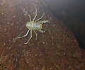
Munidopsis polymorpha
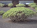
Euphorbia balsamifera


History

View over a lava field towards the Montañas del Fuego
Lanzarote is believed to have been the first Canary Island to be settled. The Phoenicians may have visited or settled there, though no material evidence survives. The first known record came from Roman author Pliny the Elder in the encyclopaedia Naturalis Historia on an expedition to the Canary Islands.[15] The names of the islands (then called Insulae Fortunatae or the "Fortunate Isles") were recorded as Junonia (Fuerteventura), Canaria (Gran Canaria), Ninguaria (Tenerife), Junonia Major (La Palma), Pluvialia (El Hierro), and Capraria (La Gomera). Lanzarote and Fuerteventura, the two easternmost Canary Islands, were only mentioned as the archipelago of the "purple islands".[clarification needed] The Roman poet Lucan and the Greek astronomer and geographer Ptolemy gave their precise locations.[16] It was settled by the Majos tribe of the Guanches.[citation needed] After the fall of the Western Roman Empire, the Canary Islands were ignored until 999, when the Arabs arrived at the island which they dubbed al-Djezir al-Khalida (among other names).

Overlooking the harbour in Puerto del Carmen's Old Town
In 1336, a ship arrived from Lisbon under the guidance of Genoese navigator Lancelotto Malocello, who used the alias "Lanzarote da Framqua". A fort was later built in the area of Montaña de Guanapay near today's Teguise. Castilian slaving expeditions in 1385 and 1393 seized hundreds of Guanches and sold them in Spain, initiating the slave trade in the islands.[17][18] French explorer Jean de Béthencourt arrived in 1402, heading a private expedition under Castilian auspices. Bethencourt first visited the south of Lanzarote at Playas de Papagayo, and the French overran the island within a matter of months. The island lacked mountains and gorges to serve as hideouts for the remaining Guanche population, and so many Guanches were taken away as slaves that only 300 Guanche men were said to have remained.
At the southern end of the Yaiza municipality, the first European settlement in the Canary Islands appeared in 1402 in the area known as El Rubicón, where the conquest of the Archipelago began.[19] In this place, the Cathedral of Saint Martial of Limoges was built. The cathedral was destroyed by English pirates in the 16th century. A diocese was moved in 1483 to Las Palmas de Gran Canaria (Roman Catholic Diocese of Canarias).[19] In 1404, the Castilians (with the support of the King of Castile) came and fought the local Guanches, who were further decimated. The islands of Fuerteventura and El Hierro were later similarly conquered. In 1477, a decision by the royal council of Castile confirmed a grant of Lanzarote and Fuerteventura, with the smaller islands of Ferro and Gomera to the Castilian nobles Herrera, who held their fief until the end of the 18th century.[20] In 1585, the Ottoman admiral Murat Reis temporarily seized Lanzarote. In the 17th century, pirates raided the island and took 1,000 inhabitants into slavery in Cueva de los Verdes.

Sunset overlooking the beach in Puerto del Carmen
From 1730 to 1736, the island was hit by a series of volcanic eruptions, producing 32 new volcanoes in a stretch of 18 kilometres (11 miles). The priest of Yaiza, Don Andrés Lorenzo Curbelo, documented the eruption in detail until 1731. Lava covered a quarter of the island's surface, including the most fertile soil and 11 villages. 100 smaller volcanoes were located in the area called Montañas del Fuego, the "Mountains of Fire". In 1768, drought affected the deforested island, and winter rains did not fall. Much of the population was forced to emigrate to Cuba and the Americas, including a group which formed a significant addition to the Spanish settlers in Texas at San Antonio de Bexar in 1731. Another volcanic eruption occurred within the range of Tiagua in 1824, which was less violent than the major eruption between 1730 and 1736.
In 1927, Lanzarote and Fuerteventura became part of the province of Las Palmas. Several archaeological expeditions have uncovered the prehistoric settlement at the archaeologic site of El Bebedero in the village of Teguise.[21] In one of those expeditions, by a team from the University of Las Palmas de Gran Canaria and a team from the University of Zaragoza, yielded about 100 Roman potsherds, nine pieces of metal, and one piece of glass. The artefacts were found in strata dated between the 1st and 4th centuries. They show that Romans did trade with the Canarians, though there is no evidence of settlements.[16]
The island has a UNESCO Biosphere Reserve protected site status. According to a report in the Financial Times, this status was endangered by a local corruption scandal. Since May 2009, police have arrested the former president of Lanzarote, the former mayor of Arrecife and more than 20 politicians and businessmen in connection with illegal building permits along Lanzarote's coastline. UNESCO has threatened to revoke Lanzarote's Biosphere Reserve status, "if the developments are not respecting local needs and are impacting on the environment".[22][23] The President of the Cabildo of Lanzarote denied "any threat to Lanzarote's UNESCO status".[24]
Notable people
Juan Leal (1676–1742/1743), Spanish settler and politician, born on the island
Juan Curbelo (1680–1760), Spanish politician, born on the island
Salvador Rodríguez (1688–unknown), Spanish politician, born on the island
José Clavijo y Fajardo (1726–1806), Spanish publicist, born on the island
Blas Cabrera Felipe (1878–1945), Spanish physicist, born on the island
César Manrique (1919–1992), Spanish artist, born and died on the island
José Saramago (1922–2010), Portuguese writer, resided and died on the island
Manuel Medina (born 1935), Spanish politician, born on the island
Rosana Arbelo (born 1963), Spanish singer, born on the island
Princess Alexia of Greece and Denmark (born 1965), Greek royalty, resides on the island
Goya Toledo (born 1969), Spanish actress and model, born on the island
Carlos Morales Quintana (born 1970), Spanish architect and husband of Princess Alexia, born and resides on the island
Jonathan Pérez Olivero (born 1982), Spanish footballer, born on the island
Patricia Díaz Perea (born 1984), Spanish triathlete, represents Lanzarote-based club Triatlón Titanes
Jordi Martín (born 1991), Spanish footballer, born on the island
Festivals
The most established festival on the island is held each year on 15 September in the village of Mancha Blanca, in honour of Our Lady of Dolours (Virgen de los Dolores), also called the "Virgin of the Volcanoes" (the Patron Saint of Lanzarote). People from all over the island participate in this pilgrimage, mostly dressed in traditional costumes.
Gallery

Hacha Grande, in the south of the island, viewed from the road to Papagayo beach

Salinas de Janubio, in the west of the island
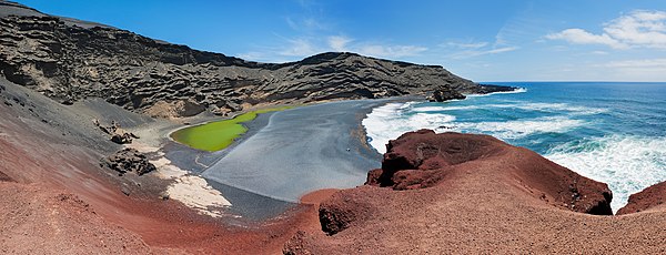
Crater and laguna in El Golfo
References
^ Population referred to the January 1, 2018 Archived 1 January 2019 at boe.es [Error: unknown archive URL]
^ "Diccionario Ínsuloamaziq-Tyterogaka". Archived from the original on 21 October 2013..mw-parser-output cite.citationfont-style:inherit.mw-parser-output .citation qquotes:"""""""'""'".mw-parser-output .citation .cs1-lock-free abackground:url("//upload.wikimedia.org/wikipedia/commons/thumb/6/65/Lock-green.svg/9px-Lock-green.svg.png")no-repeat;background-position:right .1em center.mw-parser-output .citation .cs1-lock-limited a,.mw-parser-output .citation .cs1-lock-registration abackground:url("//upload.wikimedia.org/wikipedia/commons/thumb/d/d6/Lock-gray-alt-2.svg/9px-Lock-gray-alt-2.svg.png")no-repeat;background-position:right .1em center.mw-parser-output .citation .cs1-lock-subscription abackground:url("//upload.wikimedia.org/wikipedia/commons/thumb/a/aa/Lock-red-alt-2.svg/9px-Lock-red-alt-2.svg.png")no-repeat;background-position:right .1em center.mw-parser-output .cs1-subscription,.mw-parser-output .cs1-registrationcolor:#555.mw-parser-output .cs1-subscription span,.mw-parser-output .cs1-registration spanborder-bottom:1px dotted;cursor:help.mw-parser-output .cs1-ws-icon abackground:url("//upload.wikimedia.org/wikipedia/commons/thumb/4/4c/Wikisource-logo.svg/12px-Wikisource-logo.svg.png")no-repeat;background-position:right .1em center.mw-parser-output code.cs1-codecolor:inherit;background:inherit;border:inherit;padding:inherit.mw-parser-output .cs1-hidden-errordisplay:none;font-size:100%.mw-parser-output .cs1-visible-errorfont-size:100%.mw-parser-output .cs1-maintdisplay:none;color:#33aa33;margin-left:0.3em.mw-parser-output .cs1-subscription,.mw-parser-output .cs1-registration,.mw-parser-output .cs1-formatfont-size:95%.mw-parser-output .cs1-kern-left,.mw-parser-output .cs1-kern-wl-leftpadding-left:0.2em.mw-parser-output .cs1-kern-right,.mw-parser-output .cs1-kern-wl-rightpadding-right:0.2em
^ Photo: Famara Official Tourism Office of the Canaries Archived 21 July 2010 at the Wayback Machine
^ "Eyeless Creature Discovered in Undersea Tunnel". LiveScience. LiveScience. 25 August 2009.
^ abc "Lanzarote Weather and Climate". spain-lanzarote.com. Retrieved 2017-11-22.
^ "Arrecife, Spain Köppen Climate Classification (Weatherbase)". weatherbase.com.
^ "Guía resumida del clima en España (1981–2010)". Archived from the original on 18 November 2012.
^ "Timanfaya". Lanzarote Guide. Retrieved 1 August 2017.
^ Population referred to the January 1, 2018 Archived 1 January 2019 at boe.es [Error: unknown archive URL]
^ "Población de derecho de Lanzarote según municipio, grupo de edad y sexo (2006)" [Legal population of Lanzarote by municipality, age group and sex (2006)]. Centro de Datos. Cabildo de Lanzarote (in Spanish). Retrieved 2017-11-22.
^ "Población de derecho de Lanzarote según municipio, grupo de edad y sexo (2008)" [Legal population of Lanzarote by municipality, age group and sex (2008)]. Centro de Datos. Cabildo de Lanzarote. Retrieved 2017-11-22.
^ "Informe sobre la Población de Lanzarote — Marzo 2006" (PDF). Archived from the original (pdf) on 3 March 2009. Retrieved 6 August 2018.
^ "Tráfico de pasajeros, operaciones y carga en los aeropuertos españoles 2008" (pdf). Retrieved 24 November 2009.
^ "BOC – 1991/061. Viernes 10 de Mayo de 1991 – 577". gobcan.es.
^ Pliny the Elder. "Ch 37 The Fortunate Islands". In John Bostock. The Natural History. Book VI. Retrieved 18 November 2016.
^ ab "Roman Trade with the Canary Islands". Retrieved 24 November 2009.
^ Crosby, Alfred W. (2004). Ecological Imperialism: The Biological Expansion of Europe, 900–1900. Cambridge University Press. ISBN 978-1-107-39404-9.
^ Mercer, John (1980). The Canary Islanders: their prehistory, conquest, and survival. Collings. pp. 148–159. ISBN 978-0-86036-126-8.
^ ab San Marcial del Rubicón y los Obispados de Canarias
^ Kamen, Henry (2004). Empire: How Spain Became a World Power, 1492-1763. HarperCollins. p. 11. ISBN 978-0-06-093264-0.
^ Atoche Peña, Pablo. "EXCAVACIONES on the Canary islands". www.personales.ulpgc.es. Retrieved 18 November 2016.
^ Barr, Caelainn; Mulligan, Mark (5 July 2010). "Lanzarote faces losing its eco status". Financial Times. London, Madrid. Retrieved 12 November 2010.
^ Building craze threatens to end Lanzarote's biosphere status The Independent. 7 July 2010
^ Greenslade, Roy (8 July 2010). "Canary Islands protests at Financial Times investigation". Greenslade Blog. London: The Guardian. Retrieved 12 November 2010.
Further reading
.mw-parser-output .refbeginfont-size:90%;margin-bottom:0.5em.mw-parser-output .refbegin-hanging-indents>ullist-style-type:none;margin-left:0.mw-parser-output .refbegin-hanging-indents>ul>li,.mw-parser-output .refbegin-hanging-indents>dl>ddmargin-left:0;padding-left:3.2em;text-indent:-3.2em;list-style:none.mw-parser-output .refbegin-100font-size:100%
Pott, Richard; Hüppe, Joachim; de la Torre, Wolfredo Wildpret (2003). Die Kanarischen Inseln: Natur- und Kulturlandschaften [The Canary Islands. Natural and Cultural Landscapes] (in German). Ulmer. ISBN 978-3-8001-3284-3.
Wilkens, Horst (2009). Lanzarote: Blind Crabs, Hoopoes and Volcanoes; a Guide to the Countryside, Plants and Animals of an Exceptional Volcanic Island. Naturalanza, Strecker. ISBN 978-3-942999-02-1.
Strecker, Ulrike; Wilkens, Horst (2009). Lanzarote - Leben Auf Lava: Vida Sobre Lava - Life on Lava. Naturalanza, Strecker. ISBN 978-3-942999-03-8.
Cracknell, Nick. Island Zero. self published. p. 294. ISBN 978-1976414107. a fiction thriller set entirely on the island.
External links
![]() Media related to Lanzarote at Wikimedia Commons
Media related to Lanzarote at Wikimedia Commons
- Official tourism site of Lanzarote
Lanzarote at Curlie Lanzarote travel guide from Wikivoyage
Islands and provinces of the Canary Islands | ||
|---|---|---|
| Main islands |
|  |
| Other islands |
| |
| Provinces |
| |


