Gdów
Gdów | |
|---|---|
Village | |
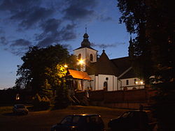
 Historic Gdów Church by Night | |
 Gdów | |
| Coordinates: 49°54′26″N 20°11′55″E / 49.90722°N 20.19861°E / 49.90722; 20.19861 | |
| Country | |
| Voivodeship | Lesser Poland |
| County | Wieliczka |
| Gmina | Gdów |
| Elevation | 220 m (720 ft) |
| Population | 4,500 |
| Website | http://www.gdow.pl/ |

Monument on Mound in Gdów Cemetery to Polish Nationalists Slain in Battle of Gdów (1846)

Face of Virgin Mary on Statue Sculpted by Edward Stehlik at Sylwester Kusionowicz Grave
Gdów [ɡduf] is a village in Wieliczka County, Lesser Poland Voivodeship, in southern Poland. It is the seat of the gmina (administrative district) called Gmina Gdów. It lies approximately 14 kilometres (9 mi) south-east of Wieliczka and 26 km (16 mi) south-east of the regional capital Kraków.[1]
The village has a population of 4,500.
Contents
1 History
2 People
3 External links
4 References
History
Archaeological excavations conducted in and around Gdów attest that settlements existed in the area in the Paleolithic, Neolithic and Bronze ages.
From the records of Jan Długosz (pl) the first permanent settlement was founded in the eleventh century by the wealthy Gedkę Family (pl), bearing the Griffin (pl) coat of arms, who probably also founded the church. The church was reported for the first time in 1272 in a document that is the oldest document discovered to-date referencing Gdów. A major influence on the development of Gdów was its location at the crossroads of trade routes leading to Hungary and Austria, Kraków to Limanowa (pl) and Bochnia (pl) to Myślenice (pl). Larger development of the settlement was hampered by the Raba river which often burst its banks.
Legend has it that in the early fifteenth century King Władysław III Warneńczyk (pl) lost his way while heading for Niepołomice (pl) castle but was saved by the Lady of Gdów (pl) who pointed him in the correct direction. In 1444 King Władysław in appreciation granted a special dispensation to the church and Mary, and Gdów was transferred to Court Secretary Fihauser. In later years Gdów often changed owners, among them Stanislaw II (Wielopolski) and Nicholas II, with the last owners in the late seventeenth century being the Lubomirski Family (pl). Augustus III of Saxony (pl) granted Gdów the privilege of organizing four fairs each year and a weekly market effectively giving Gdów the status of a city.
In 1772 the First Polish Partition (pl) placed Gdów together with the lands situated on the right bank of the Vistula River under Austrian rule. Later, during the Kraków Uprising, an important battle took place on the outskirts of Gdów and adjacent to the local cemetery. The Battle of Gdów, chronicled by the local priest Ludwik Kusionowicz, took place on February 26, 1846. Austrian troops commanded by General Ludwig von Benedek and peasants from other regions encouraged by Austrian authorities easily defeated the Polish nationalist "insurgents" led by the absent Colonel Suchorzewski. Many were slaughtered in the aftermath of the fighting but a collective grave for 154 of the insurgents killed during the battle was subsequently created in the corner of the cemetery under a mound crowned with an impressive monument. The cemetery also contains the grave of Sylwester Kusionowicz, "nephew" of Ludwik, under a beautiful and evocative statue of the Virgin Mary, created by the master sculptor Edward Stehlik (pl), which poignantly looks out over the Gdów battlefield.
After Poland regained its independence Gdów became the administrative centre for the local district lying within Wieliczka County.
People
Andrzej Kusionowicz Grodyński (born October 22, 1861, died July 24, 1925 in Cieszyn), President of the Silesian Court of Appeal, Polish circuit judge, secretary Cieszyn Education Society (pl), Polish lawyer, doctor of law, editor Gwiazdka Cieszyńska;
Michał Grażyński (pl) (born 'May 12', 1890, died December 10, 1965 in London), Governor of Silesia, independence and social activist, served in military and led scout movement, doctor of philosophy and law.
External links
Jewish Community in Gdów on Virtual Shtetl
References
^ "Central Statistical Office (GUS) - TERYT (National Register of Territorial Land Apportionment Journal)" (in Polish). 2008-06-01..mw-parser-output cite.citationfont-style:inherit.mw-parser-output .citation qquotes:"""""""'""'".mw-parser-output .citation .cs1-lock-free abackground:url("//upload.wikimedia.org/wikipedia/commons/thumb/6/65/Lock-green.svg/9px-Lock-green.svg.png")no-repeat;background-position:right .1em center.mw-parser-output .citation .cs1-lock-limited a,.mw-parser-output .citation .cs1-lock-registration abackground:url("//upload.wikimedia.org/wikipedia/commons/thumb/d/d6/Lock-gray-alt-2.svg/9px-Lock-gray-alt-2.svg.png")no-repeat;background-position:right .1em center.mw-parser-output .citation .cs1-lock-subscription abackground:url("//upload.wikimedia.org/wikipedia/commons/thumb/a/aa/Lock-red-alt-2.svg/9px-Lock-red-alt-2.svg.png")no-repeat;background-position:right .1em center.mw-parser-output .cs1-subscription,.mw-parser-output .cs1-registrationcolor:#555.mw-parser-output .cs1-subscription span,.mw-parser-output .cs1-registration spanborder-bottom:1px dotted;cursor:help.mw-parser-output .cs1-ws-icon abackground:url("//upload.wikimedia.org/wikipedia/commons/thumb/4/4c/Wikisource-logo.svg/12px-Wikisource-logo.svg.png")no-repeat;background-position:right .1em center.mw-parser-output code.cs1-codecolor:inherit;background:inherit;border:inherit;padding:inherit.mw-parser-output .cs1-hidden-errordisplay:none;font-size:100%.mw-parser-output .cs1-visible-errorfont-size:100%.mw-parser-output .cs1-maintdisplay:none;color:#33aa33;margin-left:0.3em.mw-parser-output .cs1-subscription,.mw-parser-output .cs1-registration,.mw-parser-output .cs1-formatfont-size:95%.mw-parser-output .cs1-kern-left,.mw-parser-output .cs1-kern-wl-leftpadding-left:0.2em.mw-parser-output .cs1-kern-right,.mw-parser-output .cs1-kern-wl-rightpadding-right:0.2em
| Wikimedia Commons has media related to Gdów. |
Coordinates: 49°54′26″N 20°11′55″E / 49.90722°N 20.19861°E / 49.90722; 20.19861
This Wieliczka County location article is a stub. You can help Wikipedia by expanding it. |