Lyme Bay

Lyme Bay shown within Great Britain
Lyme Bay is an area of the English Channel situated in the southwest of England between Start Bay in the west and Portland in the east. The counties of Devon and Dorset front onto the bay.
Contents
1 Geology
2 History
3 Wildlife
4 Settlements
5 Rivers
6 References
7 External links
Geology
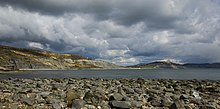
Golden Cap across Lyme Bay from Lyme Regis.
The area around Lyme Bay is part of a World Heritage Site, the Jurassic Coast, named for its Jurassic geology.
History
Many of the earliest discoveries of dinosaur and other prehistoric reptile remains were in the area surrounding Lyme Regis and Charmouth. Notable among these were the discoveries made by self-educated palaeontologist and fossil collector Mary Anning, in the 1820s.
The weather in the bay is temperate by English standards, and far more temperate than many other places at a similar latitude. The reason for this is the warming action of the Gulf Stream. The area along the coast of Lyme Bay is thus a popular holiday destination. On 22 March 1993, four schoolchildren died in what is known as the Lyme Bay kayaking tragedy[1].
Lyme Bay was the site of Exercise Tiger[2], a practice run for the D-Day invasion of France in 1944, using the beach called Slapton Sands near Slapton, Devon as the practice landing area. The operation went horribly wrong when German E-boats appeared on the scene and attacked the landing craft, killing 749 American Army and Navy personnel in the middle of the bay.
A ship commissioned in 2007 for the Royal Fleet Auxiliary carries the name of the area, RFA Lyme Bay[3].
Wildlife
Tank wrecks from the D-Day practice provide a venue for diving. Marine life includes the Devon cup coral[4] (Caryophyllia smithii) and rare pink sea fan[5] (Eunicella verrucosa). The reefs have been under threat from scallop dredging which, if unregulated, might destroy the coral's habitat. Devon Wildlife Trust has been campaigning to protect the reefs, calling for an end to the dredging and trawling within a 60-square-mile (160 km2) zone to help the reefs recover. About 20% of this area is now protected by a voluntary agreement made between the DEFRA and the fishermen of the South West Inshore Fishermen's Association[6].
Settlements
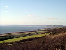
Golden Cap and East Devon from Burton Bradstock.
- Axmouth
- Beer
- Branscombe
- Charlestown, Dorset
- Dawlish Warren
- Teignmouth
- Exmouth
Fortuneswell -and the Isle of Portland- Budleigh Salterton
- Eype
- Charmouth
- Lyme Regis
- Otterton
- Seaton
- Sidmouth
- West Bay
Rivers
Rivers that flow into Lyme Bay include the Exe, Otter, Teign, Sid and Axe in Devon, and the Lim, Char, Brit and Bride in Dorset[7].
References
^ https://www.independent.co.uk/news/uk/the-school-canoe-tragedy-canoe-instructors-were-not-qualified-teachers-no-official-checks-on-centres-1499567.html
^ Fenton, Ben (26 April 2004). "The disaster that could have scuppered Overlord". The Daily Telegraph. Retrieved 30 June 2016..mw-parser-output cite.citationfont-style:inherit.mw-parser-output qquotes:"""""""'""'".mw-parser-output code.cs1-codecolor:inherit;background:inherit;border:inherit;padding:inherit.mw-parser-output .cs1-lock-free abackground:url("//upload.wikimedia.org/wikipedia/commons/thumb/6/65/Lock-green.svg/9px-Lock-green.svg.png")no-repeat;background-position:right .1em center.mw-parser-output .cs1-lock-limited a,.mw-parser-output .cs1-lock-registration abackground:url("//upload.wikimedia.org/wikipedia/commons/thumb/d/d6/Lock-gray-alt-2.svg/9px-Lock-gray-alt-2.svg.png")no-repeat;background-position:right .1em center.mw-parser-output .cs1-lock-subscription abackground:url("//upload.wikimedia.org/wikipedia/commons/thumb/a/aa/Lock-red-alt-2.svg/9px-Lock-red-alt-2.svg.png")no-repeat;background-position:right .1em center.mw-parser-output .cs1-subscription,.mw-parser-output .cs1-registrationcolor:#555.mw-parser-output .cs1-subscription span,.mw-parser-output .cs1-registration spanborder-bottom:1px dotted;cursor:help.mw-parser-output .cs1-hidden-errordisplay:none;font-size:100%.mw-parser-output .cs1-visible-errorfont-size:100%.mw-parser-output .cs1-subscription,.mw-parser-output .cs1-registration,.mw-parser-output .cs1-formatfont-size:95%.mw-parser-output .cs1-kern-left,.mw-parser-output .cs1-kern-wl-leftpadding-left:0.2em.mw-parser-output .cs1-kern-right,.mw-parser-output .cs1-kern-wl-rightpadding-right:0.2em
^ https://www.fleetmon.com/vessels/rfa-lyme-bay_9240768_30095/?language=en
^ https://www.arkive.org/devonshire-cup-coral/caryophyllia-smithii/
^ http://www.arkive.org/pink-sea-fan/eunicella-verrucosa/
^ https://www.theguardian.com/environment/2012/jul/02/fishing-limit-lyme-bay-catches
^ http://wrt.org.uk/project/rivers-lim-axe/
External links
Devon Wildlife Trusts page about the Lyme Bay coral reefs- Save Lyme Bay Reefs
Coordinates: 50°42′N 2°54′W / 50.700°N 2.900°W / 50.700; -2.900


