Seram Island
 Seram Island | |
 | |
| Geography | |
|---|---|
| Location | Oceania |
| Archipelago | Molucca Islands |
| Area | 17,100 km2 (6,600 sq mi) |
| Area rank | 52nd |
| Highest elevation | 3,027 m (9,931 ft) |
| Highest point | Binaiya |
| Administration | |
Indonesia | |
| Province | Maluku |
| Regencies | Central Maluku, East Seram, West Seram |
| Demographics | |
| Population | 434,113 (2010) |
| Pop. density | 25.4 /km2 (65.8 /sq mi) |
| Ethnic groups | Manusela, Nuaulu |
| Additional information | |
| Time zone |
|
Seram (formerly spelled Ceram; also Seran or Serang) is the largest and main island of Maluku province of Indonesia, despite Ambon Island's historical importance. It is located just north of smaller Ambon Island and a few other surrounding islands, such as Haruku, Geser, Nusalaut, Banda and Saparua.
Contents
1 Geography and geology
2 Ecology
3 History
4 Administration
5 Religion
6 Economy
7 See also
8 References
9 External links
Geography and geology
Seram is traversed by a central mountain range, the highest point of which, Mount Binaiya, is covered with dense rain forests. Its remarkably complex geology is because of its location at the meeting of several tectonic microplates, which has been described as "one of the most tectonically complex areas on Earth".[1] Seram actually falls on its own microplate, which has been twisted around by 80° in the last 8 million years[2] by the relatively faster movement of the Papua microplate. Meanwhile, along with the northward push of the Australian Plate, this has resulted in the uplift that gives north-central Seram peaks of over 3000 m. On the island are important karst areas. In the mountains near Sawai is the cave Hatu Saka, currently the deepest cave in Indonesia (-388 m). In Taniwell district, on the north coast, is the underground river Sapalewa, one of the largest underground rivers on the planet.[3][4][5]
The population of the island in the 2010 Census was 434,113 people, administered among 3 regencies, Maluku Tengah Regency had 170,392 people on Seram Island itself[6] and 191,306 on the lesser islands (majority on Ambon Island), the entirety of Seram Bagian Barat Regency and Seram Bagian Timur Regency.[7]
Ecology
Seram Island is remarkable for its high degree of localised bird endemism.[8] From the 117 species of birds on the island, 14 are endemic, including the eclectus parrot, purple-naped lory, salmon-crested cockatoo, Seram masked owl, lazuli kingfisher, sacred kingfisher, grey-necked friarbird and Moluccan king parrot.[9]
The mammals found on Seram include Asian species (murid rodents) as well as Australasian marsupials. The montane area of Seram supports the greatest number of endemic mammals of any island in the region. It harbors 38 mammal species and includes nine species that are endemic or near endemic, several of which are limited to montane habitats. These include the Seram bandicoot, Moluccan flying fox, Seram flying-fox, Manusela mosaic-tailed rat, spiny Ceram rat and the Ceram rat, all considered threatened.[10]
Saltwater crocodiles exist within some of the island's rivers, including the Salawai River.
In the eastern part of the island, Manusela National Park has been established in 1997, covering an area of 1,890 km² (11% of the island).[9]
History
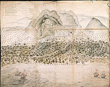
Dutch fort at Loki and Company troops in the interior, c. 1652
Most central Moluccans consider Seram to be their original ancestral home and it is still known colloquially as Nusa Ina (Mother Island).[11][12]
In the fifteenth and sixteenth centuries, Seram was generally within the sphere of influence of Ternate, although it was often ruled more directly by the Ternaten vassal state of Buru. The expedition of António de Abreu (as captain) and Francisco Serrão sighted and explored the entire southern coast of Seram in early 1512, for the first time for Europeans.[13]Portuguese missionaries were active there in the 16th century. Dutch trading posts were opened in the early 17th century, and the island came under nominal Dutch control c. 1650. In the 1780s, Seram provided a key base of support for Prince Nuku of Tidore's long-running rebellion against Dutch rule. From 1954 until 1962 the island's mountain terrain was the scene of an armed guerilla struggle against Indonesian rule by the counter revolutionary Republic of South Moluccas movement led by Soumokil.
Administration
Seram includes three of the regencies within the province of Maluku. West Seram (Kabupaten Seram Bagian Barat), capital at Dataran Hunipopu, had a population (2003) of 140,657; and Eastern Seram (Kabupaten Seram Bagian Timur), capital at Dataran Hunimoa, had a population (2003) of 78,336. The Central Maluku Regency (Kabupaten Maluku Tengah), with its capital at Masohi, includes the middle part of Ceram, as well as some other smaller islands.
Religion
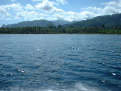
View from a boat towards Tulehu, on the North Seram coast
Seram has been traditionally associated with the animism of the indigenous Alfur (or Nuaulu), a West Melanesian people who reputedly retained a custom of headhunting until the 1940s.[14] Today, however, most of the population of Seram today is either Muslim or Christian due to both conversion and immigration. Seram was affected by the violent inter-religious conflict that swept Maluku province starting in late 1998, resulting in tens of thousands of displaced persons across the province[15] but after the Malino II Accord agreement tempers cooled. Seram has been peaceful for many years but towns like Masohi remain informally divided into de facto Christian and Muslim sections.
Around 7,000 people belonging to the Manusela tribe follow Hinduism.[16]
Economy
Copra, resin, sago, and fish are important products. Oil is produced in the northeast near Bula by CITIC Seram Energy[17] who took over from KUFPEC (Indonesia) Limited in 2006.[18] The Oseil oil field is located onshore in the northeast of the island in the Seram Non-Bula Production Sharing Contract area.[17] The discovery well was drilled in 1993.[17] As of end 2010 the Seram Non-Bula Block had estimated proven oil reserves of 9.7 million barrels.[17] Most production comes from the Jurassic Manusela carbonate formation.[19][20]
See also
- Islands of Indonesia
- Alfur
- Manusela
- Wemale
- Alune
- 1899 Ceram earthquake
References
^ Cooper, Ian. "Seram Geology". Archived from the original on January 6, 2002..mw-parser-output cite.citationfont-style:inherit.mw-parser-output qquotes:"""""""'""'".mw-parser-output code.cs1-codecolor:inherit;background:inherit;border:inherit;padding:inherit.mw-parser-output .cs1-lock-free abackground:url("//upload.wikimedia.org/wikipedia/commons/thumb/6/65/Lock-green.svg/9px-Lock-green.svg.png")no-repeat;background-position:right .1em center.mw-parser-output .cs1-lock-limited a,.mw-parser-output .cs1-lock-registration abackground:url("//upload.wikimedia.org/wikipedia/commons/thumb/d/d6/Lock-gray-alt-2.svg/9px-Lock-gray-alt-2.svg.png")no-repeat;background-position:right .1em center.mw-parser-output .cs1-lock-subscription abackground:url("//upload.wikimedia.org/wikipedia/commons/thumb/a/aa/Lock-red-alt-2.svg/9px-Lock-red-alt-2.svg.png")no-repeat;background-position:right .1em center.mw-parser-output .cs1-subscription,.mw-parser-output .cs1-registrationcolor:#555.mw-parser-output .cs1-subscription span,.mw-parser-output .cs1-registration spanborder-bottom:1px dotted;cursor:help.mw-parser-output .cs1-hidden-errordisplay:none;font-size:100%.mw-parser-output .cs1-visible-errorfont-size:100%.mw-parser-output .cs1-subscription,.mw-parser-output .cs1-registration,.mw-parser-output .cs1-formatfont-size:95%.mw-parser-output .cs1-kern-left,.mw-parser-output .cs1-kern-wl-leftpadding-left:0.2em.mw-parser-output .cs1-kern-right,.mw-parser-output .cs1-kern-wl-rightpadding-right:0.2em
^ Linthout, Kees; Hendrik Helmers (January–February 1994). "Pliocene obducted, rotated and migrated ultramafic rocks and obduction-induced anatectic granite, SW Seram and Ambon, Eastern Indonesia". Journal of Southeast Asian Earth Sciences. 9 (1–2): 95–109. doi:10.1016/0743-9547(94)90068-X.
^ "Seram 2012". Scribd. Retrieved 2016-01-05.
^ https://www.scribd.com/doc/294386822/Seram-2015
^ "Seram Speleologia 76 2016". Scribd. Retrieved 2017-09-20.
^ "Hasil Sensus Penduduk 2010 : Agregat Data per Kecamatan" (PDF). Sp2010.bps.go.id. Retrieved 2013-09-21.
^ "Statistics Indonesia". Bps.go.id. Archived from the original on 2013-09-21. Retrieved 2013-09-20.
^ BirdLife International: Saving Asia's threatened birds Archived 2010-11-30 at the Wayback Machine., 2003, retrieved 19 May 2010
^ ab Inonesian Ministry of Forestry Archived 2010-12-26 at the Wayback Machine., retrieved 19 May 2010
^ "Seram rain forests". Terrestrial Ecoregions. World Wildlife Fund. Retrieved 19 May 2010.
^ "Homepage Ema - Huaresi Rehung". Ema-huaresi.com. Archived from the original on 2013-09-21. Retrieved 2013-09-20.
^ Lonely Planet Indonesia 7th Edition, page 840
^ Cortesão, Armando (1944). The Suma Oriental of Tomé Pires: an account of the east, from the Red Sea to Japan, written in Malacca and India in 1512–1515/The Book of Francisco Rodrigues rutter of a voyage in the Red Sea, nautical rules, almanack and maps, written and drawn in the east before 1515. The Hakluyt Society.
^ Lonely Planet Indonesia, 8th edition p762
^ "Indonesia". Hrw.org. Retrieved 2013-09-20.
^ Note: the Indonesia definition of Hinduism is a complex legal matter; in effect Hinduism was a supercategory used to define non Islamic and Christian religions hence any pagan style religion. This is not to say that it is not related to Hinduism at its root, however.
^ abcd "Oil". Seram Non-Bula Block, Indonesia. CITIC Resources Holdings Limited. Archived from the original on 2013-04-19.
^ [1] Archived March 9, 2010, at the Wayback Machine.
^ Hu xueyan (May 2011). "The application of seismic anisotropy technology in fractured carbonate reservoir" (PDF). 73rd EAGE Conference & Exhibition. LandOcean Energy Services.
^ "Seram (non-Bula) projects". Lion Energy Limited. Archived from the original on 2007-08-30.
External links
| Wikimedia Commons has media related to Seram. |
Seacology Seram Island Health Clinic Project Seacology- Alifuru Consciousness Video
Coordinates: 3°08′S 129°30′E / 3.133°S 129.500°E / -3.133; 129.500
Authority control |
|
|---|


