Papua (province)
Papua | |||
|---|---|---|---|
Province | |||
  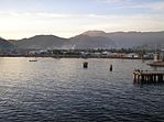    Clockwise, from top: Lake Sentani, Puncak Jaya, Warsa waterfall, Mount Sumantri, Kurulu Village War Chief, Yapen Island, Betlehem Church Wamena | |||
| |||
| Motto(s): Karya Swadaya (Sanskrit) (Work with one's own might) | |||
 Location of Papua in Indonesia | |||
| Coordinates (Jayapura): 2°32′S 140°43′E / 2.533°S 140.717°E / -2.533; 140.717Coordinates: 2°32′S 140°43′E / 2.533°S 140.717°E / -2.533; 140.717 | |||
| Country | |||
| Established | 1 January 2000 | ||
| Capital | |||
| Government | |||
| • Body | Papuan Regional Government | ||
| • Governor | Lukas Enembe[1] (PD & Golkar) | ||
| • Vice Governor | Klemen Tinal | ||
| Area | |||
| • Total | 319,036.05 km2 (123,180.51 sq mi) | ||
| Area rank | 1st | ||
| Highest elevation | 4,884 m (16,024 ft) | ||
| Population (2014) | |||
| • Total | 3,486,432 | ||
| • Rank | 21st | ||
| • Density | 11/km2 (28/sq mi) | ||
| Health Ministry 2014 Estimate | |||
| Demographics | |||
| • Ethnic groups | Papuan Melanesian (including Aitinyo, Aefak, Asmat, Agast, Dani, Ayamaru, Mandacan, Biak, Serui) Javanese Bugis Mandar Minangkabau Batak Minahasan Chinese. | ||
| • Religion | Christianity (83.15%) Islam (15.88%) Hinduism (0.09%) Buddhism (0.05%) Other (0.82%) | ||
| • Languages | Indonesian (official) 269 indigenous Papuan Austronesian languages[2] | ||
| Time zone | UTC+9 (Indonesia Eastern Time) | ||
| Postcodes | 90xxx, 91xxx, 92xxx | ||
| Area codes | (62)9xx | ||
| ISO 3166 code | ID-PA | ||
| Vehicle sign | PA | ||
| HDI | |||
| HDI rank | 34th (2016) | ||
| Largest city by area | Jayapura – 935.92 square kilometres (361.36 sq mi) | ||
| Largest city by population | Jayapura – (256,705 – 2010) | ||
| Largest regency by area | Merauke Regency – 44,071.00 square kilometres (17,015.91 sq mi) | ||
| Largest regency by population | Jayawijaya Regency – (207,480 – 2010) | ||
| Website | Papua.go.id | ||


Papua is the largest and easternmost province of Indonesia, comprising most of Western New Guinea. It is bordered by the nation of Papua New Guinea to the east, the province of West Papua to the west, the Pacific Ocean to the north, and the Arafura Sea to the south. According to the 2010 census by Statistics Indonesia, Papua had a population of 2,833,381, majority of whom are Christians.[3] The province is divided into twenty-eight regencies and one city. Its capital and largest city is Jayapura.
The province was formerly called Irian Jaya and comprised the entire Western New Guinea until the inauguration of the province of West Papua in 2003. In 2002, Papua adopted its current name and was granted a special autonomous status by the Indonesian legislation. Puncak Jaya is the province's highest mountain as well as the highest point of Indonesia.
Contents
1 Naming
2 Government
3 Special autonomy status
4 Administrative divisions
4.1 Provincial decentralisation history
4.2 Proposed new regencies, cities and provinces
4.2.1 South Papua
4.2.2 Central Papua
4.3 Jayapura City
5 Geography
6 Ethnic groups
7 Demographics
7.1 Religion
8 Economy
9 Ecology
10 See also
11 References
12 External links
Naming
"Papua" is the official Indonesian and internationally recognised name for the province.
During the Dutch colonial era the region was known as part of "Dutch New Guinea" or "Netherlands New Guinea". Since its annexation in 1969, it became known as "West Irian" or "Irian Barat" until 1973, and thereafter renamed "Irian Jaya" (roughly translated, "Glorious Irian") by the Suharto administration.[4][5] This was the official name until the name "Papua" was adopted in 2002. Today, the indigenous inhabitants of this province prefer to call themselves Papuans.
The name "West Papua" was adopted in 1961 by the New Guinea Council until the United Nations Temporary Executive Authority (UNTEA) transferred administration to the Republic of Indonesia in 1963. "West Papua" has since been used by Papuans as a self-identifying term, especially by those demanding self-determination, and usually refers to the whole of the Indonesian portion of New Guinea. The other Indonesian province that shares New Guinea, West Irian Jaya, has been officially renamed as West Papua, or Papua Barat. The entire western New Guinea is often referred to as "West Papua" internationally – especially among networks of international solidarity with the West Papuan independence movement.
Government

Nius Kogoya, Provincial Representative for Tolikara
The province of Papua is governed by a directly elected governor (currently Lukas Enembe) and a regional legislature, People's Representative Council of province of Papua (Dewan Perwakilan Rakyat Papua).[citation needed] A government organisation that only exists in Papua is the Papuan People's Council (Majelis Rakyat Papua) Papuan People's Council), which was formed by the Indonesian Government in 2005 as a coalition of Papuan tribal chiefs, tasked with arbitration and speaking on behalf of Papuan tribal customs.
Indonesian sovereignty over Papua dates back to 1969, when Indonesia conducted a referendum (referred to by the Indonesian government as the Act of Free Choice) on the self-determination of the peoples of Papua under an agreement with the United Nations to respect any result. Instead of conducting a democratic referendum amongst the general population, Indonesian security forces forcibly coerced a small number of tribal elders to vote to join Indonesia; some elders were not even made aware that a referendum was to be conducted beforehand. Nevertheless, the agreement with the UN was nominally upheld, and was recognised by the international community in spite of protests. This intensified the independence movement among indigenous West Papuans, deepening the Papua conflict, which began when the Dutch withdrew from the East Indies in 1963. The conflict has continued to the present, with Indonesian security forces being accused of numerous human rights abuses in their suppression of the independence movement. The Indonesian government maintains tight control over the region, barring foreign journalists or rights monitors from entering; those who do must do so covertly.[6]
In 1999 it was proposed to split the province into three government-controlled sectors, sparking Papuan protests.[7] In January 2003 President Megawati Sukarnoputri signed an order dividing Papua into three provinces: Central Irian Jaya (Irian Jaya Tengah), Papua (or East Irian Jaya, Irian Jaya Timur), and West Papua (Irian Jaya Barat). The formality of installing a local government for Jaraka in Irian Jaya Barat (West) took place in February 2003 and a governor was appointed in November; a government for Irian Jaya Tengah (Central Irian Jaya) was delayed from August 2003 due to violent local protests. The creation of this separate Central Irian Jaya Province was blocked by Indonesian courts, who declared it to be unconstitutional and in contravention of the Papua's special autonomy agreement. The previous division into two provinces was allowed to stand as an established fact.[8]
Special autonomy status
The province of Papua is one of three provinces to have obtained special autonomy status, the others being Aceh and West Papua. According to Law 21/2001 on Special Autonomy Status (UU Nomor 21 Tahun 2001 tentang Otonomi khusus Papua), the provincial government of Papua is provided with authority within all sectors of administration, except for the five strategic areas of foreign affairs, security and defense, monetary and fiscal affairs, religion and justice. The provincial government is authorised to issue local regulations to further stipulate the implementation of the special autonomy, including regulating the authority of districts and municipalities within the province. Due to its special autonomy status, Papua province is provided with significant amount of special autonomy funds, which can be used to benefit its indigenous peoples. But the province has low fiscal capacity and it is highly dependent on unconditional transfers and the above-mentioned special autonomy fund, which accounted for about 55% of total revenues in 2008.
After obtaining its special autonomy status, in order to allow the local population access to timber production benefits, the Papuan provincial government issued a number of decrees, enabling:
- a Timber Logging Permit for Customary Communities, which enabled local people to carry out timber extraction in small concessions (250 to 1,000 hectares) for one year through a community-based or participatory community cooperative;
- a Permit to Manage Customary Forests, which was a timber extraction permit for larger concessions (up to 2,000 hectares) for a maximum of 20 years;
- logging companies had to pay compensations to local communities in addition to all other fees and taxes collected by the national government.
Administrative divisions
As of 2010 (following the separation of West Papua Province in 2003), the residual Papua Province consisted of 28 regencies (kabupaten) and one autonomous city (kota); these regencies and the city are together subdivided as at 2018 into 560 districts (distriks), and thence into 5,521 "villages" (kelurahan and desa). In Papua, as well as in the province of West Papua, kecamatan are commonly referred to as distrik.
The regencies (kabupaten) and the city (kota) are listed below with their areas and their populations at the 2010 Census and according to the latest official (January 2014) Estimates.
| Name | Area (km2) | Population Estimate 2005 | Population Census 2010 | Population Estimate 2014 | Capital | Number of Districts | Number of Villages | HDI[9] 2014 Estimates |
|---|---|---|---|---|---|---|---|---|
| Asmat Regency | 31,983.69 | 61,642 | 76,577 | 94,227 | Agats | 19 | 221 | 0.459 (Low) |
| Boven Digoel Regency | 27,108.00 | * | 55,784 | 68,641 | Tanah Merah | 20 | 112 | 0.582 (Low) |
| Mappi Regency | 24,118.00 | 65,219 | 81,658 | 100,479 | Kepi | 15 | 164 | 0.557 (Low) |
| Merauke Regency | 44,071.00 | 154,310 | 195,716 | 240,826 | Merauke | 20 | 190 | 0.673 (Medium) |
| Southern group (South Papua) | 281,171 | 409,735 | 504,173 | |||||
| Biak Numfor Regency | 2,602.00 | 99,204 | 126,798 | 156,023 | Biak | 19 | 268 | 0.703 (High) |
| Deiyai Regency | 537.39 | # | 62,119 | 76,436 | Tigi | 5 | 67 | 0.481 (Low) |
| Dogiyai Regency | 4,237.40 | # | 84,230 | 103,643 | Kigamani | 10 | 79 | 0.522 (Low) |
| Intan Jaya Regency | 3,922.02 | # | 40,490 | 49,822 | Sugapa | 8 | 97 | 0.435 (Low) |
Kepulauan Yapen Regency (Yapen Islands) | 2,050.00 | 70,201 | 82,951 | 102,070 | Serui | 16 | 165 | 0.648 (Medium) |
| Mimika Regency | 21,633.00 | 126,344 | 182,001 | 223,949 | Timika | 18 | 152 | 0.704 (High) |
| Nabire Regency | 11,112.61 | 159,548 | 129,893 | 159,831 | Nabire | 15 | 81 | 0.662 (Medium) |
| Paniai Regency | 6,525.25 | 111,412 | 153,432 | 188,796 | Enarotali | 23 | 221 | 0.539 (Low) |
| Supiori Regency | 678.32 | 12,152 | 15,874 | 19,533 | Sorendiweri | 5 | 38 | 0.597 (Low) |
| Waropen Regency | 10,977.09 | 21,181 | 24,639 | 30,318 | Botawa | 11 | 100 | 0.619 (Medium) |
| Western group (Central Papua) | 595,042 | 902,427 | 1,110,421 | |||||
Jayapura (city) | 935.92 | 197,396 | 256,705 | 315,872 | Jayapura City | 5 | 39 | 0.778 (High) |
| Jayapura Regency | 11,157.15 | 90,972 | 111,943 | 137,744 | Sentani | 19 | 144 | 0.695 (Medium) |
| Jayawijaya Regency | 7,030.66 | 207,480 | 196,085 | 241,280 | Wamena | 40 | 332 | 0.533 (Low) |
| Keerom Regency | 8,390.00 | 37,048 | 48,536 | 59,723 | Waris | 11 | 91 | 0.627 (Medium) |
| Lanny Jaya Regency | 2,248.00 | # | 148,522 | 182,754 | Tiom | 39 | 355 | 0.432 (Low) |
Mamberamo Raya Regency (Great Mamberamo) | 23,813.91 | # | 18,365 | 22,598 | Burmeso | 8 | 60 | 0.478 (Low) |
Mamberamo Tengah Regency (Central Mamberamo) | 1,275.00 | # | 39,537 | 48,650 | Kobakma | 5 | 59 | 0.431 (Low) |
| Nduga Regency | 2,168.00 | # | 79,053 | 97,274 | Kenyam | 32 | 248 | 0.253 (Low) |
Pegunungan Bintang Regency (Bintang Mountains Regency) | 15,682.00 | 86,979 | 65,434 | 80,516 | Oksibil | 34 | 277 | 0.396 (Low) |
| Puncak Regency | 8,055.00 | # | 93,218 | 114,702 | Ilaga | 25 | 206 | 0.380 (Low) |
| Puncak Jaya Regency | 4,989.51 | 111,488 | 101,148 | 124,461 | Mulia | 26 | 305 | 0.443 (Low) |
| Sarmi Regency | 17,742.00 | 31,500 | 32,971 | 40,570 | Sarmi | 10 | 94 | 0.604 (Medium) |
| Tolikara Regency | 5,588.13 | 44,100 | 114,427 | 140,801 | Karubaga | 46 | 545 | 0.461 (Low) |
| Yahukimo Regency | 17,152.00 | 134,702 | 164,512 | 202,430 | Sumohai | 51 | 511 | 0.463 (Low) |
| Yalimo Regency | 1,253.00 | # | 50,763 | 62,463 | Elelim | 5 | 300 | 0.442 (Low) |
- * The 2005 estimated population of Boven Digoel Regency is included in the figure quoted for Merauke Regency, from which Boven Digoel was divided.
- # The 2005 estimated population of this regency are included in the figures quoted for the existing regency from which the newer regency was divided in 2007 or 2008.
Provincial decentralisation history
In 2000, the present area of Papua Province originally consisted of nine regencies:
- Biak Numfor, Jayapura, Jayawijaya, Merauke, Mimika, Nabire, Paniai, Puncak Jaya and Yapen Waropen
On 12 November 2002, the following nine additional regencies were created:
- Keerom and Sarmi Regencies were split from Jayapura Regency
- Bintang Mountains (Pegunungan Bintan), Tolikara and Yahukimo Regencies were split from Jayawijaya Regency
- Asmat, Boven Digoel and Mappi Regencies were split from Merauke Regency (this larger area, the original Merauke Regency, is since 2013 planned to be created a new province under the name of South Papua (Papua Selatan))
Yapen Waropen Regency was split into Yapen Islands Regency (Kepulauan Yapen) and Waropen Regency
On 8 January 2004, Supiori Regency was split from Biak Numfor Regency, bringing the total number of diregencies to nineteen.
On 15 March 2007, under Law No. 19/2007, the following two regencies were created:
Mamberamo Raya Regency was formed from parts of Sarmi and Waropen Regencies
Dogiyai Regency was similarly formed from the southern districts of Nabire Regency
On 4 January 2008, five other new regencies were created by Home Affairs Minister Mardiyanto who also installed five temporary regents. These five new regencies were:
- 4 formerly from part of Jayawijaya Regency:
Central Mamberamo Regency with five districts, with Kobakma as the regental seat. Created by the Law No. 3/2008, the first regent was David Pagawak.
Yalimo Regency also has five districts, with Elelim as the regental capital. Created by the Law No. 4/2008, the first regent was Elia Ibrahim Loupatty.
Lanny Jaya Regency with ten districts, with Tiom as the regental capital. Created by the Law No.5/2008, the first regent was Pribadi Sukartono. The number of districts was subsequently increased to thirty-nine.
Nduga Regency with eight districts, with Kenyam as the regental capital. Created by the Law No. 6/2008, the first regent was Hans Dortheus. The number of districts was subsequently increased to thirty-two.
- 1 formerly from part of Puncak Jaya Regency:
Puncak Regency also had eight districts, with Ilaga as the regental capital. Created by the Law No. 7/2008, the first regent was Simon Alom. The number of districts was subsequently increased to twenty-five.
Within 2008, Intan Jaya and Deiyai Regencies were split from Paniai Regency.
Proposed new regencies, cities and provinces
On 25 October 2013 the Indonesian House of Representatives (DPR) began reviewing draft laws on the establishment of 57 prospective regencies/cities (and 8 new provinces).[10] This included two new provinces to be formed from parts of the existing Papua Province (and one new province from the existing West Papua Province), as well as the creation of seventeen new regencies and two new cities (independent municipalities). The new regencies will be:
- Moyo, Muara Digul and Admi Korbay
- Gili Menawa, Balin Senter, Bogaga, Puncak Trikora, Katengban, Okika, Yalimek, Ser Yahukimo Western Mountains, Mambera Hulu, Southwest Yahukimo, East Yahukimo and North Yahukimo
- Northwest Yapen, East Yapen, Numfor Island and Ghondumi Sisare
And the new cities will be the municipalities of:
- Merauke and Lembah Baliem (Baliem Valley)
The two new provinces from parts of the existing Papua province have recently been approved by Indonesia's House of Representatives:
- South Papua, and
- Central Papua
Another new province, to be split from West Papua will be Southwest Papua.[11]
South Papua

Morning in Senggo Village, Mappi Regency, Papua, Indonesia.
The proposed South Papua (Papua Selatan) Province would cover an area of 119,749 square km, which is rich in natural resources. It will encompass four existing regencies:
- Asmat, Boven Digoel, Mappi and Merauke
And will thus equate closely to the original Merauke Regency prior to the splitting of that entity in 2002. Within the existing regencies, new regencies to be added are the following:
- Moyo (from Boven Digoel Regency)
- Muara Digul and Admi Korbay (both from Mappi Regency)
And a new municipality of Merauke City (which is scheduled to be created from Merauke Regency)
Central Papua
According to a 20 January 2012 report in the Cenderawasih Pos Jakarta, the central government is moving forward with the creation of "Central Papua". At that time it was envisaged that the new province would comprise ten existing regencies:
- Supiori, Biak Numfor, Yapen Islands, Waropen, Nabire, Dogiyai, Deiyai, Intan Jaya, Paniai, and Mimika
The new Central Papua Province, and the residual Papua Province, would together include the new regencies.
First of, for the residual Papua Province:
- Gili Menawa (from Jayapura Regency)
- Balin Senter (from Lanny Jaya Regency and Tolikara Regency)
- Boboga (from Tolikara Regency)
- Puncak Trikora (from Lanny Jaya Regency)
- Katengban (from Bintang Mountains Regency)
- Okika (from Jayawijaya Regency), and
- Yalimek, Ser Yahukimo Western Mountains, Mambera Hulu, Southwest Yahukimo, East Yahukimo and North Yakuhimo (all six from Yahukimo Regency)
And a new municipality of Lembah Baliem (Baliem Valley, created from Jayawijaya Regency)
And for the new Central Papua Province:
- Northwest Yapen and East Yapen (both from Yapen Islands Regency)
- Numfor Island (from Biak Numfor Regency), and
- Ghondumi Sisare (from Waropen Regency)
Jayapura City

Jayapura at night
The city of Jayapura also has the status of an autonomous city, equal to a regency. It was founded on 7 March 1910 as Hollandia and is the capital. Since Indonesian administration the name of the city has been changed to Kotabaru, then to Sukarnopura before its current name, Jayapura.[citation needed] Jayapura is also the largest city of Papua Province, with a small but active tourism industry.[clarification needed] It is built on a slope overlooking the bay. Cenderawasih University (UNCEN) campus at Abepura houses the University Museum where some of the Asmat artifacts collected by Michael Rockefeller is stored.[12] Both Tanjung Ria beach, near the market at Hamadi – site of 22 April 1944 Allied invasion during World War II – and the site of General Douglas MacArthur's World War II headquarters at Ifar Gunung have monuments commemorating the events.[citation needed]
Geography
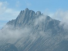
Puncak Jaya is the tallest mountain between the Himalayas and the Andes.
A central east–west mountain range dominates the geography of the island of New Guinea, over 1,600 km (1,000 mi) in total length. The western section is around 600 km (400 mi) long and 100 km (60 mi) across.[citation needed] The province contains the highest mountains between the Himalayas and the Andes, rising up to 4,884 metres (16,024 ft) high, and ensuring a steady supply of rain from the tropical atmosphere.[citation needed] The tree line is around 4,000 metres (13,000 ft) elevation and the tallest peaks contain permanent equatorial glaciers,[citation needed] increasingly melting due to a changing climate.[citation needed] Various other smaller mountain ranges occur both north and west of the central ranges.[citation needed] Except in high elevations, most areas possess a hot humid climate throughout the year, with some seasonal variation associated with the northeast monsoon season.
The southern and northern lowlands stretch for hundreds of kilometres and include lowland rainforests, extensive wetlands, savanna grasslands, and expanses of mangrove forest.[citation needed] The southern lowlands are the site of Lorentz National Park, also a UNESCO World Heritage Site.[13]
The province's largest river is the Mamberamo located in the northern part of the province.[citation needed] The result is a large area of lakes and rivers known as the Lakes Plains region.[citation needed] The Baliem Valley, home of the Dani people, is a tableland 1,600 metres (5,200 ft) above sea level in the midst of the central mountain range.[citation needed]Puncak Jaya, also known by its Dutch colonial name, "Carstensz Pyramid", is a limestone mountain peak 4,884 metres (16,024 ft) above sea level.[citation needed] It is the highest peak of Oceania.[citation needed]
Ethnic groups
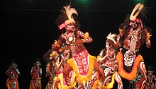
Papuan dance from Yapen

Yali people
The following are some of the most well-known ethnic groups of Papua:
- Amungme
- Asmat
- Bauzi
- Dani
- Kamoro
- Kombai
- Korowai
- Mee
- Sentani
- Yali
- Yei
The Yei (pronounced Yay) are sometimes known as the Jei, Je, Yei-nan people.
There are approximately 2,500 speakers of the Yei language. 40% Ethno Religionists- animistic tribal religion 60% Catholics and other Christians (blended with animistic beliefs & customs):
The Yei language is believed to have two dialects observed by a Wycliffe, SIL language survey in 2001. At home the Yei people speak their own language but use Indonesian for trade, wider communication and at school. Most Yei are literate in Indonesian.
There are elementary schools in each village. About 10–30% of children continue in middle school. Very few go to high school.
The nearest high school is in Merauke city.
They live primarily by hunting, fishing, and gardening short and long term crops in the lowlands. The Yei diet mainly consists of rice, vegetables, fish and roasted sago.
With their land at an altitude of less than 100 meters above sea level, the Yei people can best be accessed by vehicle on the road from Merauke or by motorized canoe up the Maro River. There is no airstrip or airplane access other than float plane which is currently available from Merauke through MAF by about a 15-minute flight to Toray.
The Poo and Bupul villages have a clinic but people still use traditional medicines.
There is very little infrastructure in the area: no telephones or toilets. At night electricity is run from a generator. There are single side-band radios (SSBs) in Bupul, Tanas, Poo, and Erambu villages, mainly used by the police and military force. Most villages get their drinking water from the Maro River, but some get it from wells or by collecting rain.[citation needed]
Demographics
 Play media
1995 ABC news report on the impact of transmigration and development on the Dani
| Historical population | ||
|---|---|---|
| Year | Pop. | ±% |
| 1971 | 923,440 | — |
| 1980 | 1,173,875 | +27.1% |
| 1990 | 1,648,708 | +40.5% |
| 1995 | 1,942,627 | +17.8% |
| 2000 | 2,220,934 | +14.3% |
| 2010 | 2,833,381 | +27.6% |
| 2014 | 3,486,482 | +23.1% |
| Source: Badan Pusat Statistik 2010, 2014 Health Ministry Estimate[14] | ||
The population of Papua province has a fertility rate of 2.9 children per woman[citation needed] The population grew from the 1.9 million recorded in the 2000 Indonesia Census, to 2.9 million as recorded by the 2010 Census,[15] and is officially estimated to be at about 3.5 million in 2014. Since the early 1990s Papua has had the highest population growth rate of all Indonesian provinces at over 3% annually.[citation needed] This is partly a result of birth rates, but mainly due to migration from other parts of Indonesia.[citation needed] While indigenous Papuans formed the near-totality of the population in 1961, they are now roughly 50% of the population,[citation needed] the other half being composed of non-Papuan migrants coming from other parts of Indonesia. An overwhelming percentage of these migrants came as part of a government-sponsored transmigration program.[citation needed]
The densest population center, other than the large coastal cities that house Indonesian bureaucratic and commercial apparatus, is located in and around the town of Wamena in the Baliem Valley of the Central Highlands.[citation needed]
Religion
According to the 2010 census, 83.15% of the Papuans identified themselves as Christian with 65.48% being Protestant and 17.67% being Roman Catholic. 15.88% of the population was Muslim and less than 1% were Buddhist or Hindu.[17] There is also substantial practice of animism, the traditional religion for many Papuans, with many blending animistic beliefs with other religions such as Christianity.
Economy
In 2011, Papuan caretaker governor Syamsul Arief Rivai claimed Papua's forests cover 42 million hectares with an estimated worth of Rp.700 trillion ($78 billion) and that if the forests were managed properly and sustainably, they could produce over 500 million cubic meters of logs per annum.[18]
The Grasberg Mine, the world's largest gold mine and third largest copper mine,[19] is located in the highlands near Puncak Jaya, the highest mountain in Papua.
Ecology
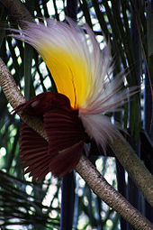
Paradisaea apoda, native to Papua, displaying its feathers
The island has an estimated 16,000 species of plant, 124 genera of which are endemic.[citation needed] Papua's known forest fauna includes; marsupials (including possums, wallabies, tree-kangaroos, cuscuses); other mammals (including the endangered long-beaked echidna); bird species such as birds-of-paradise, cassowaries, parrots, and cockatoos; the world's longest lizards (Papua monitor); and the world's largest butterflies.[20]
The waterways and wetlands of Papua are also home to salt and freshwater crocodile, tree monitors, flying foxes, osprey, bats and other animals;[citation needed] while the equatorial glacier fields remain largely unexplored.[citation needed]
Protected areas within Papua province include the World Heritage Lorentz National Park, and the Wasur National Park, a Ramsar wetland of international importance.[citation needed]
In February 2006, a team of scientists exploring the Foja Mountains, Sarmi, discovered new species of birds, butterflies, amphibians, and plants, including possibly the largest-flowered species of rhododendron.[21]
Ecological threats include logging-induced deforestation, forest conversion for plantation agriculture (including oil palm), smallholder agricultural conversion, the introduction and potential spread of alien species such as the crab-eating macaque which preys on and competes with indigenous species, the illegal species trade, and water pollution from oil and mining operations.[citation needed]
See also
- Asmat Swamp
- List of earthquakes in Indonesia
- List of rivers of Papua
- Papua Conflict
References
- King, Peter, West Papua Since Suharto: Independence, Autonomy, or Chaos?. University of New South Wales Press, 2004, .mw-parser-output cite.citationfont-style:inherit.mw-parser-output qquotes:"""""""'""'".mw-parser-output code.cs1-codecolor:inherit;background:inherit;border:inherit;padding:inherit.mw-parser-output .cs1-lock-free abackground:url("//upload.wikimedia.org/wikipedia/commons/thumb/6/65/Lock-green.svg/9px-Lock-green.svg.png")no-repeat;background-position:right .1em center.mw-parser-output .cs1-lock-limited a,.mw-parser-output .cs1-lock-registration abackground:url("//upload.wikimedia.org/wikipedia/commons/thumb/d/d6/Lock-gray-alt-2.svg/9px-Lock-gray-alt-2.svg.png")no-repeat;background-position:right .1em center.mw-parser-output .cs1-lock-subscription abackground:url("//upload.wikimedia.org/wikipedia/commons/thumb/a/aa/Lock-red-alt-2.svg/9px-Lock-red-alt-2.svg.png")no-repeat;background-position:right .1em center.mw-parser-output .cs1-subscription,.mw-parser-output .cs1-registrationcolor:#555.mw-parser-output .cs1-subscription span,.mw-parser-output .cs1-registration spanborder-bottom:1px dotted;cursor:help.mw-parser-output .cs1-hidden-errordisplay:none;font-size:100%.mw-parser-output .cs1-visible-errorfont-size:100%.mw-parser-output .cs1-subscription,.mw-parser-output .cs1-registration,.mw-parser-output .cs1-formatfont-size:95%.mw-parser-output .cs1-kern-left,.mw-parser-output .cs1-kern-wl-leftpadding-left:0.2em.mw-parser-output .cs1-kern-right,.mw-parser-output .cs1-kern-wl-rightpadding-right:0.2em
ISBN 0-86840-676-7.
^ "Lukas-Klemen, Gubernur dan Wakil Gubernur Papua Terpilih". 13 February 2013.
^ Gordon, Raymond G., Jr. (2005). "Languages of Indonesia (Papua)". Ethnologue: Languages of the World. Retrieved 15 March 2009.CS1 maint: Multiple names: authors list (link)
^ "Badan Pusat Statistik". www.bps.go.id. Retrieved 5 November 2018.
^ Simpson, Brad (9 July 2004). "Indonesia's 1969 Takeover of West Papua Not by "Free Choice"". National Security Archive. Retrieved 15 March 2009.
^ "Undang-2, Inpres, dll. – Laws, Decrees, etc". Cenderawasih University. 23 February 2005. Retrieved 15 March 2009.
^ "Goodbye Indonesia". People and Power. Al Jazeera English. 31 January 2013. Retrieved 1 February 2013.
^ "World Evangelical". Archived from the original on 6 December 2004. Retrieved 10 May 2016.
^ King, 2004, p. 91
^ Indeks-Pembangunan-Manusia-2014
^ Jakarta Post, 14 November 2013
^ "New Provinces Receive the Nod – Jakarta Globe". Jakarta Globe. Retrieved 10 May 2016.
^ "Museum Loka Budaya Simpan Jejak Kematian Michael Rockefeller di Asmat – Papua Untuk Semua – Informasi Berita Harian Papua yang Terbaru". Retrieved 10 May 2016.
^ "Lorentz National Park". UNESCO. Retrieved 9 August 2016.
^ http://www.depkes.go.id/downloads/Penduduk%20Kab%20Kota%20Umur%20Tunggal%202014.pdf Estimasi Penduduk Menurut Umur Tunggal Dan Jenis Kelamin 2014 Kementerian Kesehatan
^ "Archived copy". Archived from the original on 24 August 2010. Retrieved 30 August 2010.CS1 maint: Archived copy as title (link)
^ "Population by Region and Religion in Indonesia". BPS. 2010.
^ "Peringatan". Retrieved 10 May 2016.
^ "Forests in Papua are valued at $78 billion". 24 August 2011.
^ Jane Perlez and Raymond Bonner (2005): Below a Mountain of Wealth, a River of Waste. The New York Times, 27 December 2005. Accessed 6 December 2011.
^ Dispatch – The Republic of Irian Barat. NationStates, Accessed 15 September 2017.
^ Kirby, Terry (7 February 2006). "Scientists hail discovery of hundreds of new species in remote New Guinea". The Independent. Retrieved 16 March 2009.
External links
| Wikimedia Commons has media related to Papua (province). |
- Official website
- Languages and ethnic groups of Papua Province, SIL Ethnologue
Regencies and cities of Papua | ||
|---|---|---|
Capital: Jayapura | ||
| Regencies |
| |
| City |
| |
Provinces of Indonesia | ||
|---|---|---|
Capital: Jakarta | ||
| Sumatra |
|  |
| Java |
| |
| Kalimantan |
| |
| Lesser Sunda |
| |
| Sulawesi |
| |
| Maluku |
| |
| Papua |
| |
Lists by
| ||
Authority control |
|
|---|


