Nógrád County
Nógrád County Nógrád megye | |||
|---|---|---|---|
| Counties of Hungary | |||
   Descending, from top: Hills near Hollókő, Castle of Drégely, View of Hollókő | |||
| |||
 Nógrád County within Hungary | |||
| Country | |||
| Region | Northern Hungary | ||
| County seat | Salgótarján | ||
| Districts | 6 districts
| ||
| Government | |||
| • President of the General Assembly | Nándor Skuczi (Fidesz-KDNP) | ||
| Area | |||
| • Total | 2,545.48 km2 (982.82 sq mi) | ||
| Area rank | 18th in Hungary | ||
| Population (2015) | |||
| • Total | 195,923[1] | ||
| • Rank | 19th in Hungary | ||
| Postal code | 2175 – 2179, 2610, 2611, 2616 – 2619, 264x – 269x, 304x – 31xx | ||
| Area code(s) | (+36) 32, 35 | ||
| ISO 3166 code | .mw-parser-output .monospacedfont-family:monospace,monospace HU-NO | ||
| Website | www.nograd.hu | ||


Nógrád (Hungarian: Nógrád megye, pronounced [ˈnoːɡraːd]; Slovak: Novohradská župa) is a county (Hungarian: megye) of Hungary.
Contents
1 Description
2 History
3 Demographics
3.1 Ethnicity
3.2 Religion
4 Regional structure
5 Politics
5.1 Presidents of the General Assembly
6 Municipalities
7 Gallery
8 References
9 External links
Description
Nógrád county lies in northern Hungary. It shares borders with Slovakia and the Hungarian counties Pest, Heves and Borsod-Abaúj-Zemplén. The capital of Nógrád county is Salgótarján. Its area is 2,544 km².
Nógrád is famous for its historic architecture of ancient Gothic churches and stone castles dated to the 13th century. Other historic landmark includes the baroque buildings constructed in the 18th century and the Vay, Teleki. Much of the northern border of the county is formed by the river Ipoly. The mountain ranges Börzsöny, Cserhát and Mátra lie partly in the county.
Due to the mountains, the county is characterised by small villages nestled in the valleys. The two largest settlements are Balassagyarmat, the former county seat, and Salgótarján, which has become a center of industry in the early 20th century due to coal mines nearby.
History
Nógrád (-Hungarian, in Latin: comitatus Neogradiensis, in German: Neuburg or Neograd, in Slovak: Novohrad) was also the name of a historic administrative county (comitatus) of the Kingdom of Hungary. The name stems from the former Nógrád castle (Slovak: Novohrad - this name is still used in Slovakia as well as the informal designation of the corresponding territory, now located in southern Slovakia and in northern Hungary).
Demographics
Religion in Nógrád County (2011 census)
Catholic Church (55.4%)
Greek Catholicism (0.2%)
Lutheranism (3.9%)
Calvinism (2.1%)
Other religions (1.8%)
Non-religious (12.2%)
Atheists (0.9%)
Undeclared (23.5%)
In 2015, it had a population of 195,923 and the population density was 77/km².
| Year | County population[2] | Change |
|---|---|---|
| 1949 | 214,757 | n/a |
| 1960 | 9.74% | |
| 1970 | -0.53% | |
| 1980 | 2.48% | |
| 1990 | -5.46% | |
| 2001 | -3.03% | |
| 2011 | -8.10% |
Ethnicity
Besides the Hungarian majority, the main minorities are the Roma (approx. 15,000), Slovak (2,500) and German (1,000).
Total population (2011 census): 202,427
Ethnic groups (2011 census):[3]
Identified themselves: 192,438 persons:
Hungarians: 172,946 (89.87%)
Gypsies: 15.177 (7.89%)
Slovaks: 2,644 (1.37%)- Others and indefinable: 1,671 (0.87%)
Approx. 26,000 persons in Nógrád County did not declare their ethnic group at the 2011 census.
Religion
Religious adherence in the county according to 2011 census:[4]
- Catholic – 112,640 (Roman Catholic – 112,241; Greek Catholic – 389);
Evangelical – 7,858;
Reformed – 4,167;- Other religions – 3,672;
Non-religious – 24,717;
Atheism – 1,740;
Undeclared – 47,633.
Regional structure

District of Nógrád County
| № | English and Hungarian names | Area (km²) | Population (2011) | Density (pop./km²) | Seat | № of municipalities |
| 1 | Balassagyarmat District Balassagyarmati járás | 532.94 | 40,326 | 76 | Balassagyarmat | 29 |
| 2 | Bátonyterenye District Bátonyterenyei járás | 215.45 | 21,789 | 101 | Bátonyterenye | 8 |
| 3 | Pásztó District Pásztói járás | 551.56 | 31,729 | 58 | Pásztó | 26 |
| 4 | Rétság District Rétsági járás | 435.03 | 24,395 | 56 | Rétság | 25 |
| 5 | Salgótarján District Salgótarjáni járás | 525.23 | 64,601 | 123 | Salgótarján | 29 |
| 6 | Szécsény District Szécsényi járás | 285.26 | 19,587 | 69 | Szécsény | 14 |
| Nógrád County | 2,545.48 | 202,427 | 80 | Salgótarján | 131 | |
|---|---|---|---|---|---|---|
Politics
The regional legislature is the General Assembly.
The Nógrád County Council, elected at the 2014 local government elections, is made up of 15 counselors, with the following party composition:[5]
| | Party | Seats | Current County Assembly | ||||||||
|---|---|---|---|---|---|---|---|---|---|---|---|
| | Fidesz-KDNP | 9 | | | | | | | | | |
| | Movement for a Better Hungary (Jobbik) | 3 | | | | | | | | | |
| | Hungarian Socialist Party (MSZP) | 2 | | | | | | | | | |
| | Democratic Coalition (DK) | 1 | | | | | | | | | |
Presidents of the General Assembly
| List of Presidents, from 1990[6][7] | |
|---|---|
Ferenc Korill (SZDSZ) | 1990–1994 |
Sándor Smitnya (SZDSZ) | 1994–1998 |
Zsolt Becsó (Fidesz) | 1998–2002 |
Ottó Dóra (MSZP) | 2002–2006 |
| Zsolt Becsó (Fidesz-KDNP) | 2006–2014 |
Nándor Skuczi (Fides-KDNP) | 2014– |
Municipalities
Nógrád County has 1 urban county, 5 towns and 125 villages.
- City with county rights
(ordered by population, as of 2011 census)
 Salgótarján (37,262) – county seat
- Towns
 Balassagyarmat (16,397)
 Bátonyterenye (12,841)
 Pásztó (9,689)
 Szécsény (5,962)
 Rétság (2,822)
- Villages
- Alsópetény
- Alsótold
- Bánk
- Bárna
- Becske
- Bercel
- Berkenye
- Bér
- Bokor
- Borsosberény
- Buják
- Cered
- Csécse
- Cserháthaláp
- Cserhátsurány
- Cserhátszentiván
- Csesztve
- Csitár
- Debercsény
- Dejtár
- Diósjenő
- Dorogháza
- Drégelypalánk
- Ecseg
- Egyházasdengeleg
- Egyházasgerge
- Endrefalva
- Erdőkürt
- Erdőtarcsa
- Érsekvadkert
- Etes
- Felsőpetény
- Felsőtold
- Galgaguta
- Garáb
- Herencsény
- Héhalom
- Hollókő
- Hont
- Horpács
- Hugyag
- Iliny
- Ipolyszög
- Ipolytarnóc
- Ipolyvece
- Jobbágyi
- Karancsalja
- Karancsberény
- Karancskeszi
- Karancslapujtő
- Karancsság
- Kazár
- Kálló
- Keszeg
- Kétbodony
- Kisbágyon
- Kisbárkány
- Kisecset
- Kishartyán
- Kozárd
- Kutasó
- Legénd
- Litke
- Lucfalva
- Ludányhalászi
- Magyargéc
- Magyarnándor
- Márkháza
- Mátramindszent
- Mátranovák
- Mátraszele
- Mátraszőlős
- Mátraterenye
- Mátraverebély
- Mihálygerge
- Mohora
- Nagybárkány
- Nagykeresztúr
- Nagylóc
- Nagyoroszi
- Nemti
- Nézsa
- Nógrád
- Nógrádkövesd
- Nógrádmarcal
- Nógrádmegyer
- Nógrádsáp
- Nógrádsipek
- Nógrádszakál
- Nőtincs
- Őrhalom
- Ősagárd
- Palotás
- Patak
- Patvarc
- Piliny
- Pusztaberki
- Rákóczibánya
- Rimóc
- Romhány
- Ságújfalu
- Sámsonháza
- Somoskőújfalu
- Sóshartyán
- Szalmatercs
- Szanda
- Szarvasgede
- Szátok
- Szendehely
- Szente
- Szécsénke
- Szécsényfelfalu
- Szilaspogony
- Szirák
- Szuha
- Szurdokpüspöki
- Szügy
- Tar
- Terény
- Tereske
- Tolmács
- Vanyarc
- Varsány
- Vizslás
- Zabar
Gallery
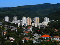
Salgótarján, the capital of the county

Hollókő village
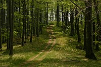
Tourist path in the Börzsöny near Diósjenő

Forgách Mansion in Szécsény
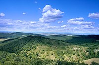
The Cserhát moutain range

Our Lady church in Mátraverebély
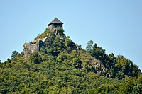
Salgó Castle

Teleki Mansion in Szirák


References
| Wikimedia Commons has media related to Nógrád County. |
| Wikivoyage has a travel guide for Nógrád County. |
^ nepesseg.com, population data of Hungarian settlements
^ népesség.com, "Nógrád megye népessége 1870-2015"
^ 1.1.6. A népesség anyanyelv, nemzetiség és nemek szerint – Frissítve: 2013.04.17.; Hungarian Central Statistical Office (in Hungarian)
^ 2011. ÉVI NÉPSZÁMLÁLÁS, 3. Területi adatok, 3.13 Nógrád megye, (in Hungarian) [1]
^ A Közgyűlés képviselői, (in Hungarian) [2]
^ Önkormányzati választások eredményei (in Hungarian)
^ General Assembly website
External links
Official site in Hungarian- Nógrád Megyei Hírlap (nhc24.hu) - The county portal
- Photos from Nograd County
Nógrád County | ||
|---|---|---|
| City with county rights |
|   |
| Towns |
| |
| Villages |
| |
| Other topics |
| |
Counties (megyék) of Hungary | ||
|---|---|---|
| ||
Coordinates: 48°00′N 19°34′E / 48.00°N 19.57°E / 48.00; 19.57


