Oromia Region
Oromia Region Oromiyaa | ||
|---|---|---|
Regional State | ||
| ||
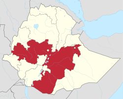 Map of Ethiopia showing Oromia Region | ||
| Country | Ethiopia | |
| Capital | Addis Abeba [1] | |
| Area | ||
| • Total | 286,612 km2 (110,662 sq mi) | |
| Area rank | 1st = In Ethiopian Regions | |
| Population (2018) | ||
| • Total | 35,000,000[2] | |
| ISO 3166 code | ET-OR | |
HDI (2017) | 0.448[3] low · 8th | |

Oromia (spelled Oromiyaa in the Oromo language; Amharic: ኦሮሚያ) is one of the nine ethnically based regional states of Ethiopia, covering 286,612 square kilometers.[4] It is bordered by the Somali Region to the east; the Amhara Region, the Afar Region and the Benishangul-Gumuz Region to the north; South Sudan, Gambela Region, and Southern Nations, Nationalities, and Peoples' Region to the west; and Kenya to the south. The 2011 census reported Oromia Region population is 35,000,000; making it the largest state in population.
Oromia includes the former Arsi Province along with portions of the former Bale, Hararghe, Illubabor, Kaffa, Shewa and Sidamo provinces. Towns in the region include Adama, Ambo, Asella, Badessa, Bale Robe, Bishoftu, Begi, Chiro, Dembidolo, Fiche, Gimbi, Goba, Haramaya, Jimma, Metu, Negele Boran, Moyale, Nekemte, Sebeta, Shashamane, and Waliso, among many others .
Contents
1 History
2 Demographics
2.1 Ethnic groups
2.2 Religion
2.2.1 Religion in entire region
2.2.2 Religion in urban areas
2.3 Languages
3 Economy
4 Presidents of the Executive Committee
5 Administrative zones
6 See also
7 References
8 External links
8.1 Media
History
Before 2000, the regional capital of Oromia was Addis Abeba (Finfinne in the Oromo language, which is also the capital of the country), on 10 June 2005, this was changed to Adama but sparked considerable controversy and this forced the government to bring back the capital to Addis Abeba[5]. Critics of the move believed the Ethiopian government wished to de-emphasize 's location within Oromia.[6]. On the other hand, the government maintained that Addis Abeba "has been found inconvenient from the point of view of developing the language, culture and history of the Oromo people."[7]
Oromia shares a boundary with almost every region of Ethiopia except for the Tigray Region. This boundary has been disputed with Oromia's neighbors in a number of cases, most notably between Oromia and the Somali Region. One attempt to resolve the dispute between the two regions was the October 2004 referendum held in about 420 kebeles in 12 woredas across five zones of the Somali Region. According to the official results of the referendum, about 80% of the disputed areas have fallen under Oromia administration, though there were allegations of voting irregularities in many of them.[8] The results led over the following weeks to minorities in these kebeles being pressured to leave. In Oromya, estimates based on figures given by local woreda and kebele authorities suggest that 21,520 people have been displaced in border woredas, namely Mieso, Doba, and Erer in the Mirab and Misraq Hararghe Zones. Federal authorities believe that this number may be overstated by as much as 11,000. In Doba, the Ministry of Federal Affairs put the number of IDPs at 6,000. There are also more than 2,500 displaced persons in Mieso.[9] In addition, there were reports of people being displaced in the border area of Moyale and Borena zones due to this conflict.[10]
On September 12, 2015 and continuing into 2016, protests broke out across Ethiopia and centered around the Oromia Region. Dozens of protesters were killed in the first days of the protests and internet service was cut in many parts of the region.
Demographics
Based on the 2007 census conducted by the Central Statistical Agency of Ethiopia (CSA), Oromia Region has a total population of 26,993,933, consisting of 13,595,006 men and 13,398,927 women; urban inhabitants number 3,370,040 or 11.3% of the population. With an estimated area of 353,006.81 square kilometers, this region has an estimated population density of 76.93 people per square kilometer. For the entire region 5,590,530 households were counted, which results in an average for the region of 4.8 persons to a household, with urban households having on average 3.8 and rural households 5.0 people. The projected population for 2017 was 32,815,995.[2]
In the previous census, conducted in 1994, the region's population was reported to be 17,088,136; urban inhabitants number 621,210 or 14% of the population.
According to the CSA, as of 2004[update], 32% of the population had access to safe drinking water, of whom 23.7% were rural inhabitants and 91.03% were urban.[11] Values for other reported common indicators of the standard of living for Oromia as of 2005[update] include the following: 19.9% of the inhabitants fall into the lowest wealth quintile; adult literacy for men is 61.5% and for women 29.5%; and the regional infant mortality rate is 76 infant deaths per 1,000 live births, which is about the same as the nationwide average of 77; at least half of these deaths occurred in the infants' first month of life.[12]
Ethnic groups
| Ethnic group | 1994 Census | 2007 Census |
|---|---|---|
Oromo | 85% | 87.8% |
Amhara | 9.1% | 7.22% |
Gurage (some of Sebat Bet Gurage, Soddo Gurage, and Silt'e) | 0.98% | 0.93% |
| other ethnic groups | 4.6% | 4% |
Figures of full ethnic background are disputed, since many ethnically mixed Ethiopians are difficult to categorize.[citation needed] Particularly, Shewa Oromos and urban Oromos are known to have assimilated with ethnic Amhara and others, while southwestern Oromos have mixed with the Sidama and other ethnicities.[citation needed] The census and the general system of governance has remained controversial and related to the politics of the country.[citation needed] For instance, mixed Ethiopians with an Oromo father and Amhara mother are registered into the census using only their father's ethnic label. Similarly, Ethiopians with an Amhara father (or from another ethnic background) and Oromo mother are registered using only their father's ethnic label.[citation needed]
Religion
Religion in entire region
| Religion | 1994 Census | 2007 Census[13] |
|---|---|---|
Muslim | 44.3% | 47.6% |
Orthodox Christians | 41.3% | 30.4% |
Protestant Christians | 8.6% | 17.7% |
traditional religions | 4.2% | 3.3% |
| other religious groups | 1.6% | 1% |
Religion in urban areas
| Religion | 1994 Census | 2007 Census[13] |
|---|---|---|
Orthodox Christians | 67.8% | 51.2% |
Muslim | 24.0% | 29.9% |
Protestant Christians | 7% | 17.5% |
| other religious groups | – | 1.5% |
Languages
Oromo (Afaan Oromoo), which is written with Latin characters, is the most commonly spoken language, spoken by 83.5% of the population. Other major languages are Amharic (11%) (especially in eastern Welega and northern Shewa), Gurage languages (Sebat Bet Gurage, Soddo, Silt'e), Hadiya, Gedeo (0.98%), especially in western and eastern Shewa; and Tigrigna (0.25%). Omotic languages are spoken by significant minorities in Jimma, Illubabor and western Welega; and some Nilo-Saharan languages (including Komo, Majang, Gumuz, and Berta) are spoken in communities scattered in the west.
Economy
The CSA reported that for 2004–2005 115,083 tons of coffee were produced in Oromia, based on inspection records from the Ethiopian Coffee and Tea Authority. This represents 50.7% of the total production in Ethiopia. Farmers in the Region had an estimated total of 17,214,540 cattle (representing 44.4% of Ethiopia's total cattle), 6,905,370 sheep (39.6), 4,849,060 goats (37.4%), 959,710 horses (63.25%), 63,460 mules (43.1%), 278,440 asses (11.1%), 139,830 camels (30.6%), 11,637,070 poultry of all species (37.7%), and 2,513,790 beehives (57.73%).[14]
According to a March 2003 World Bank publication, the average rural household has 1.14 hectares of land compared to the national average of 1.01 hectares, 24% of the population is in non-farm related jobs compared to the national average of 25%.[15]
Presidents of the Executive Committee
- Hassan Ali (1992 – 1995)
Kuma Demeksa (OPDO) (1995 – 24 July 2001)
Juneydi Sado (28 October 2001 – 6 October 2005)
Abadula Gemeda (6 October 2005 – September 2010)
Alemayehu Atomsa OPDO (September 2010 – February 2014)
Muktar Kedir OPDO (March 2014 – 2016)[16]
Lemma Megersa (June 2016 – )
Administrative zones
The Oromia is subdivided into 20 administrative zones:
- Arsi
- Bale
- Bedele
- Borena
- East Hararghe
- East Shewa
- East Welega
- Guji
- West Guji
- Horo Gudru Welega
- Illubabor
- Jimma
- Kelem Welega
- North Shewa
- South West Shewa
- West Arsi
- West Hararghe
- West Shewa
- West Welega
Adama (special zone)
Jimma (special zone)
Oromia-Finfinne (special zone)
See also
Black Gold, film- Ethiopian Ministry of Culture and Tourism
- List of woredas of the Oromia Region
References
^ "FDRE States: Basic Information, Oromia". The Federal Democratic Republic of Ethiopia. Archived from the original on 17 June 2008. Retrieved 29 May 2008..mw-parser-output cite.citationfont-style:inherit.mw-parser-output .citation qquotes:"""""""'""'".mw-parser-output .citation .cs1-lock-free abackground:url("//upload.wikimedia.org/wikipedia/commons/thumb/6/65/Lock-green.svg/9px-Lock-green.svg.png")no-repeat;background-position:right .1em center.mw-parser-output .citation .cs1-lock-limited a,.mw-parser-output .citation .cs1-lock-registration abackground:url("//upload.wikimedia.org/wikipedia/commons/thumb/d/d6/Lock-gray-alt-2.svg/9px-Lock-gray-alt-2.svg.png")no-repeat;background-position:right .1em center.mw-parser-output .citation .cs1-lock-subscription abackground:url("//upload.wikimedia.org/wikipedia/commons/thumb/a/aa/Lock-red-alt-2.svg/9px-Lock-red-alt-2.svg.png")no-repeat;background-position:right .1em center.mw-parser-output .cs1-subscription,.mw-parser-output .cs1-registrationcolor:#555.mw-parser-output .cs1-subscription span,.mw-parser-output .cs1-registration spanborder-bottom:1px dotted;cursor:help.mw-parser-output .cs1-ws-icon abackground:url("//upload.wikimedia.org/wikipedia/commons/thumb/4/4c/Wikisource-logo.svg/12px-Wikisource-logo.svg.png")no-repeat;background-position:right .1em center.mw-parser-output code.cs1-codecolor:inherit;background:inherit;border:inherit;padding:inherit.mw-parser-output .cs1-hidden-errordisplay:none;font-size:100%.mw-parser-output .cs1-visible-errorfont-size:100%.mw-parser-output .cs1-maintdisplay:none;color:#33aa33;margin-left:0.3em.mw-parser-output .cs1-subscription,.mw-parser-output .cs1-registration,.mw-parser-output .cs1-formatfont-size:95%.mw-parser-output .cs1-kern-left,.mw-parser-output .cs1-kern-wl-leftpadding-left:0.2em.mw-parser-output .cs1-kern-right,.mw-parser-output .cs1-kern-wl-rightpadding-right:0.2em
^ ab Population Projection of Ethiopia for All Regions At Wereda Level from 2014 – 2018. Federal Democratic Republic of Ethiopia Central Statistical Agency. Retrieved 4 June 2018.
^ "Sub-national HDI - Area Database - Global Data Lab". hdi.globaldatalab.org. Retrieved 2018-09-13.
^ 2011 National Statistics Archived 30 March 2013 at the Wayback Machine (accessed 7 May 2012).
^ "Chief Administrator of Oromia says decision to move capital city based on study". Walta Information Center. 11 June 2005. Archived from the original on 13 June 2005. Retrieved 25 February 2006.CS1 maint: Unfit url (link)
^ Hameso, Seyoum and Tilahun Ayanou Nebo (2000). "Ethiopia: A New Start?". The Sidama Concern. Retrieved 25 February 2006.
^ "Adama Selected as Oromiya's Capital". Walta Information Center. 13 July 2000. Archived from the original on 3 March 2006. Retrieved 25 February 2006.
^ "Somali-Oromo border referendum of December 2004" Archived 30 April 2009 at the Wayback Machine, Internal Displacement Monitoring Centre website (accessed 11 February 2009)
^ "Regional Overview: Oromia Region", Focus on Ethiopia (April 2005), p. 5 (accessed 11 February 2009)
^ "Regional Update: Oromiya", Focus on Ethiopia (May 2005), p. 5 (accessed 11 February 2009)
^ "Households by sources of drinking water, safe water sources" (PDF). CSA Selected Basic Welfare Indicators. Archived from the original (PDF) on 18 November 2008. Retrieved 28 January 2009.
^ Macro International Inc. Ethiopia Atlas of Key Demographic and Health Indicators, 2005 (PDF). Calverton: Macro International, 2008. 2008. pp. 2, 3, 10. Retrieved 28 January 2009.
^ ab Census 2007 Tables: Oromia Region Archived 13 November 2011 at the Wayback Machine, Table 3.3.
^ "CSA 2005 National Statistics – Tables D.4 – D.7" (PDF). Archived from the original (PDF) on 18 November 2008.
^ Klaus Deininger; et al. "Tenure Security and Land Related Investment, WP-2991". Archived from the original on 10 March 2007. Retrieved 23 March 2006.
^ Cahoon, Ben. "Ethiopian Regional States". www.worldstatesmen.org. Retrieved 27 March 2018.
External links
| Wikimedia Commons has media related to Oromia Region. |
Map of Oromia Region at UN-OCHA (PDF file)- FDRE States: Basic Information – Oromia
Media
- Oromia Culture and Tourism Bureau
- Oromia President office
- Sheger Times
- Oromia TV
Woredas of the Oromia Region | ||
|---|---|---|
List of districts in the Oromia Region | ||
| Arsi Zone |
| |
| Bale Zone |
| |
| Borena Zone |
| |
| East Hararghe Zone |
| |
| East Shewa Zone |
| |
| East Welega Zone |
| |
| Guji Zone |
| |
| Horo Guduru Welega Zone |
| |
| Illubabor Zone |
| |
| Jimma Zone |
| |
| Kelam Welega Zone |
| |
| North Shewa Zone |
| |
| South West Shewa Zone |
| |
| West Arsi Zone |
| |
| West Hararghe Zone |
| |
| West Shewa Zone |
| |
| West Welega Zone |
| |
| Adama Special Zone |
| |
| Jimma Special Zone |
| |
| Oromia Special Zone Surrounding Finfinne |
| |
Zones of the Oromia Region | ||
|---|---|---|
| ||
| Regions |
|
|---|---|
| Chartered cities |
|
| Provinces '"`UNIQ--templatestyles-00000023-QINU`"' (prior to 1995) |
|
Members of the Unrepresented Nations and Peoples Organization | ||
|---|---|---|
| Africa |
|  |
| North America |
| |
| South America |
| |
| Asia |
| |
| Europe |
| |
Coordinates: 7°59′21″N 39°22′52″E / 7.9890616°N 39.3811798°E / 7.9890616; 39.3811798


