Pa Sak River
| Pa Sak River (แม่น้ำป่าสัก) | |
|---|---|
 The Pa Sak River flowing east of Ayuttaya's old city | |
| Location | |
| Country | Thailand |
| Physical characteristics | |
| Source | |
| - location | Phetchabun Mountains |
| Mouth | |
- location | Chao Phraya River at Ayutthaya Island |
| Length | 513 km (319 mi) |
| Basin size | 16,291 km2 (6,290 sq mi) |
| Discharge | |
| - average | 2.4 km3 (0.58 cu mi)/yr |
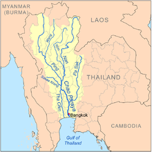
Map of the Chao Phraya River drainage basin showing the Pa Sak River
The Pa Sak River (Thai: แม่น้ำป่าสัก, RTGS: Maenam Pa Sak, IPA: [mɛ̂ːnáːm pàː sàk], Pronunciation) is a river in central Thailand. The river originates in the Phetchabun Mountains, Dan Sai District, Loei Province, and passes through Phetchabun Province as the backbone of the province. It then passes through the eastern part of Lopburi Province and Saraburi Province, until it joins together with the Lopburi River northeast of Ayutthaya Island, before it runs into the Chao Phraya River southeast of Ayutthaya near Phet Fortress. It has a length of 513 km (319 mi) and drains a watershed of 16,291 km2 (6,290 sq mi). The annual discharge is 2.4 km3 (0.58 cu mi).
The valley of the Pa Sak through the Phetchabun mountains is the main part of Phetchabun Province. As the watershed of the river is rather narrow, the amount of water in the river varies seasonally. To address drought problems in the lower Pa Sak valley, in 1994 the construction of the Pa Sak Cholasit Dam (เขื่อนป่าสักชลสิทธิ์) in Lopburi Province was built. The 4,860-meter (15,940 ft) wide and 36.5-meter (120 ft) high dam keeps a total of 0.785 km3 (0.188 cu mi) of water. The dam also supplies about 6.7 MW of hydro-electric power.
Contents
1 Tributaries
2 Pa Sak Basin
3 References
4 External links
Tributaries
Tributaries of the Pa Sak include the Lopburi River, Khlong Muak Lek, Huai Nam Phung, Huai Pa Daeng, Khlong Lam Kong, Lam Sonthi, Khlong Wang Chomphu, Khlong Huai Na, Huai Nam Chun, Huai Nam Duk, Huai Khon Kaen, Huai Yai, Khlong Saduang Yai, Khlong Ban Bong, Khlong Tarang, and Lam Phaya Klang.
Pa Sak Basin
The Pa Sak drains a total land area of 16,291 square kilometres (6,290 sq mi).[1] The Pa Sak Basin is part of the Chao Phraya watershed.
References
^ Basins of Thailand[dead link]
External links
- The Pasak Jolasit Dam project
Coordinates: 14°21′51″N 100°34′48″E / 14.36417°N 100.58000°E / 14.36417; 100.58000
This article related to a river in Thailand is a stub. You can help Wikipedia by expanding it. |


