Salisbury
| City of Salisbury | |
|---|---|
 Salisbury Cathedral from the Old George Mall in July 2016 | |
 City of Salisbury City of Salisbury shown within Wiltshire | |
| Population | 40,302 (civil parish, 2011 Census)[1] |
| OS grid reference | SU145305 |
| • London | 78 miles (126 km) |
| Civil parish |
|
| Unitary authority |
|
| Ceremonial county |
|
| Region |
|
| Country | England |
| Sovereign state | United Kingdom |
| Post town | SALISBURY |
| Postcode district | SP1, SP2 |
| Dialling code | 01722 |
| Police | Wiltshire |
| Fire | Dorset and Wiltshire |
| Ambulance | South Western |
| EU Parliament | South West England |
| UK Parliament |
|
Salisbury (locally /ˈsɔːzbəri/ SAWZ-bər-ee)[a] is a cathedral city in Wiltshire, England, with a population of 40,302,[1] at the confluence of the rivers Avon, Nadder, Ebble, Wylye and Bourne. The city is approximately 20 miles (32 km) from Southampton and 30 miles (48 km) from Bath.
Salisbury is in the southeast of Wiltshire, near the edge of Salisbury Plain. Salisbury Cathedral was formerly north of the city at Old Sarum. Following the cathedral's relocation, a settlement grew up around it which received a city charter in 1227 as New Sarum, which continued to be its official name until 2009 when Salisbury City Council was established. Salisbury railway station is an interchange between the West of England Main Line and the Wessex Main Line.
Stonehenge, a UNESCO World Heritage Site, is 8 miles (13 km) northwest of Salisbury.
Contents
1 Name
2 History
2.1 Old Sarum
2.2 New Sarum
2.3 Salisbury
3 Governance
4 Geography
4.1 Areas and suburbs
4.2 Climate
5 Demography
6 Economy
7 Culture
7.1 Salisbury Museum
8 Twin towns and sister cities
9 Education
10 Transport
10.1 Road
10.2 Bus
10.3 Railways
11 Sport and leisure
12 Notable people
12.1 Before 1900
12.2 Since 1900
13 Media
14 Bordering areas
15 In popular culture
16 See also
17 References
18 External links
Name
The name Salisbury, which is first recorded around the year 900 as Searoburg (dative Searobyrig), is a partial translation of the Roman Celtic name Sorviodūnum. The Brittonic suffix -dūnon, meaning "fortress" (in reference to the fort that stood at Old Sarum), was replaced by its Old English equivalent -burg. The first part of the name is of obscure origin. The form "Sarum" is a Latinization of Sar, a medieval abbreviation for Middle English Sarisberie.[3]
The two names for the city, Salisbury and Sarum, are humorously alluded to in a 1928 limerick from Punch:
.mw-parser-output .templatequoteoverflow:hidden;margin:1em 0;padding:0 40px.mw-parser-output .templatequote .templatequoteciteline-height:1.5em;text-align:left;padding-left:1.6em;margin-top:0
There was an old Sultan of Salisbury
Who wanted some wives for his halisbury,
So he had them sent down
By a fast train from town,
For he thought that his motor would scalisbury.[4]
The ambiguous pronunciation was also used in the following limerick:[5]
There was a young curate of Salisbury,
Whose manners were quite Halisbury-Scalisbury.
He wandered round Hampshire,
Without any pampshire,
Till the Vicar compelled him to Walisbury.[5]
Salisbury appeared in the Welsh Chronicle of the Britons as Caer-Caradog, Caer-Gradawc and Caer-Wallawg.[6][7][8] Cair-Caratauc, one of the 28 British cities listed in the History of the Britons, has also been identified with Salisbury.[9][10]
History
Old Sarum

A reconstruction of Old Sarum in the 12th century
The hilltop at Old Sarum lies near the Neolithic sites of Stonehenge and Avebury and shows some signs of early settlement.[11] It commanded a salient between the River Bourne and the Hampshire Avon, near a crossroads of several early trade-routes.[12] During the Iron Age, sometime between 600 and 300 BC, a hillfort (oppidum) was constructed around it.[12] The Romans may have occupied the site or left it in the hands of an allied tribe. At the time of the Saxon invasions, Old Sarum fell to King Cynric of Wessex in 552.[13] Preferring settlements in bottomland, such as nearby Wilton, the Saxons largely ignored Old Sarum until the Viking invasions led King Alfred (KIng of Wessex from 871 to 899) to restore its fortifications.[12] Along with Wilton, however, it was abandoned by its residents to be sacked and burned by the Dano-Norwegian king Sweyn Forkbeard in 1003.[14] It subsequently became the site of Wilton's mint.[12] Following the Norman invasion of 1066, a motte-and-bailey castle was constructed by 1070.[12] The castle was held directly by the Norman kings; its castellan was generally also the sheriff of Wiltshire.
In 1075 the Council of London established Herman as the first bishop of Salisbury,[15] uniting his former sees of Sherborne and Ramsbury into a single diocese which covered the counties of Dorset, Wiltshire, and Berkshire. In 1055, Herman had planned to move his seat to Malmesbury, but its monks and Earl Godwin objected.[16] Herman and his successor, Saint Osmund, began the construction of the first Salisbury cathedral, though neither lived to see its completion in 1092.[15] Osmund served as Lord Chancellor of England (in office c. 1070–1078); he was responsible for the codification of the Sarum Rite,[17] the compilation of the Domesday Book, which was probably presented to William at Old Sarum[12], and, after centuries of advocacy from Salisbury's bishops, was finally canonised by Pope Callixtus III in 1457.[18] The cathedral was consecrated on 5 April 1092 but suffered extensive damage in a storm, traditionally said to have occurred only five days later.[19][20]Bishop Roger was a close ally of Henry I (reigned 1100–1135): he served as viceroy during the king's absence in Normandy[21] and directed, along with his extended family, the royal administration and exchequer.[22] He refurbished and expanded Old Sarum's cathedral in the 1110s and began work on a royal palace during the 1130s, prior to his arrest by Henry's successor, Stephen.[21] After this arrest, the castle at Old Sarum was allowed to fall into disrepair, but the sheriff and castellan continued to administer the area under the king's authority.[23]
New Sarum
Bishop Hubert Walter was instrumental in the negotiations with Saladin during the Third Crusade, but he spent little time in his diocese prior to his elevation to archbishop of Canterbury.[24] The brothers Herbert and Richard Poore succeeded him and began planning the relocation of the cathedral into the valley almost immediately. Their plans were approved by King Richard I but repeatedly delayed: Herbert was first forced into exile in Normandy in the 1190s by the hostility of his archbishop Walter and then again to Scotland in the 1210s owing to royal hostility following the papal interdiction against King John. The secular authorities were particularly incensed, according to tradition, owing to some of the clerics debauching the castellan's female relations.[23] In the end, the clerics were refused permission to reenter the city walls following their rogations and processions.[25] This caused Peter of Blois to describe the church as "a captive within the walls of the citadel like the ark of God in the profane house of Baal". He advocated
Let us descend into the plain! There are rich fields and fertile valleys abounding in the fruits of the earth and watered by the living stream. There is a seat for the Virgin Patroness of our church to which the world cannot produce a parallel.[26]
His successor and brother Richard Poore eventually moved the cathedral to a new town on his estate at Veteres Sarisberias ("Old Salisburies") in 1220. The site was at "Myrifield" ("Merryfield"),[27] a meadow near the confluence of the River Nadder and the Hampshire Avon. It was first known as "New Sarum"[26] or New Saresbyri.[25] The town was laid out on a grid.

The Great West Front of Salisbury Cathedral.
Work on the new cathedral building, the present Salisbury Cathedral, began in 1221. The site was supposedly established by shooting an arrow from Old Sarum, although this is certainly a legend: the distance is over 3 km (1.9 mi). The legend is sometimes amended to claim that the arrow struck a white deer, which continued to run and died on the spot where the cathedral now rests. The structure was built upon wooden faggots on a gravel bed with unusually shallow foundations of 18 inches (46 cm) and the main body was completed in only 38 years. The 123 m or 404 ft tall spire, the tallest in the UK, was built later. With royal approval, many of the stones for the new cathedral were taken from the old one; others came from Chilmark. They were probably transported by ox-cart, owing to the obstruction to boats on the River Nadder caused by its many weirs and watermills. The cathedral is considered a masterpiece of Early English architecture. The spire's large clock was installed in 1386, and is one of the oldest surviving mechanical clocks in the world.[28] The Cathedral also contains the best-preserved of the four surviving copies of the Magna Carta.

The 15th century Doom painting in St Thomas' church
New Sarum was made a city by a charter from King Henry III in 1227[29] and, by the 14th century, was the largest settlement in Wiltshire. The city wall surrounds the Close and was built in the 14th century, again with stones removed from the former cathedral at Old Sarum. The wall now has five gates: the High Street Gate, St Ann's Gate, the Queen's Gate, and St Nicholas's Gate were original, while a fifth was constructed in the 19th century to allow access to Bishop Wordsworth's School in the Cathedral Close. During his time in the city, the composer Handel stayed in a room above St Ann's gate. The original site of the city at Old Sarum, meanwhile, fell into disuse. It continued as a rotten borough: at the time of its abolition during the reforms of 1832, its MP represented three households.

A picture of Minster Street, c. 1870
In May 1289, there was uncertainty about the future of Margaret, Maid of Norway, and her father sent ambassadors to Edward I. Edward met Robert the Bruce and others at Salisbury in October 1289, which resulted in the Treaty of Salisbury, under which Margaret would be sent to Scotland before 1 November 1290 and any agreement on her future marriage would be delayed until she was in Scotland.[30]
The Parliament of England met at New Sarum in the years 1324, 1328, and 1384.[31]
In 1450, a number of riots broke out in Salisbury at roughly the same time as Jack Cade led a famous rebellion through London. The riots occurred for related reasons, although the declining fortunes of Salisbury's cloth trade may also have been influential. The violence peaked with the murder of the bishop, William Ayscough, who been involved with the government. In 1483, a large-scale rebellion against Richard III broke out, led by his own 'kingmaker', Henry Stafford, 2nd Duke of Buckingham. After the revolt collapsed, Buckingham was executed at Salisbury, near the Bull's Head Inn. In 1664, an act for making the River Avon navigable from Christchurch to the city of New Sarum was passed[32] and the work completed, only for the project to be ruined shortly thereafter by a major flood.[33] Soon after, during the Great Plague of London, Charles II held court in Salisbury's cathedral close.
Salisbury was the site chosen to assemble James II's forces to resist the Glorious Revolution. He arrived to lead his approximately 19 000 men on 19 November 1688. His troops were not keen to fight Mary or her husband William, and the loyalty of many of James's commanders was in doubt. The first blood was shed at the Wincanton Skirmish, in Somerset. In Salisbury, James heard that some of his officers had deserted, such as Edward Hyde, and he broke out in a nosebleed, which he took as an omen that he should retreat. His commander in chief, the Earl of Feversham, advised retreat on 23 November, and the next day John Churchill defected to William. On 26 November, James's own daughter, Princess Anne, did the same, and James returned to London the same day, never again to be at the head of a serious military force in England.[34]
At the time of the 1948 Summer Olympics, held in London, a relay of runners carried the Olympic Flame from Wembley Stadium, where the Games were based, to the sailing centre at Torbay via Slough, Basingstoke, Salisbury, and Exeter.
Salisbury
The 1972 Local Government Act eliminated the administration of the City of New Sarum under its former charters, but its successor, Wiltshire County's Salisbury District, continued to be accorded its former city status. The name was finally formally amended from "New Sarum" to "Salisbury" during the 2009 changes occasioned by the 1992 Local Government Act, which established the Salisbury City Council.
On 4 March 2018, former Russian double agent Sergei Skripal and his daughter Yulia Skripal were poisoned in Salisbury with a Novichok nerve agent.[35]
Governance
Salisbury falls under two authorities created in 2009: Salisbury City Council and Wiltshire Council. It was once at the heart of the now defunct Salisbury District, which oversaw most of south Wiltshire as well as the city. When Wiltshire's local government was reorganised under a unitary authority in April 2009, Salisbury City Council was formed, although with fewer responsibilities than the former district council as it is now merely a parish.
Three electoral wards – St Martin's and Cathedral, St Edmund and Milford and St Paul's – correspond roughly to the city centre, and the rest of the parish and city council area is covered by five further wards. Netherhampton is in the Fovant and Chalke Valley ward while Laverstock and Ford parish has the same boundary as the Laverstock, Ford and Old Sarum ward.[36] These two wards are not administered by the city council.
The Member of Parliament for the Salisbury constituency, which includes the city, Wilton, Amesbury and surrounding rural areas, is John Glen (Conservative), who was first elected in 2010.
Geography

Queen Elizabeth Gardens showing part of the River Avon diverted through the gardens.
Salisbury lies in a valley. The geology of the area, as with much of South Wiltshire and Hampshire, is largely chalk. The rivers which flow through the city have been redirected, and along with landscaping, have been used to feed into public gardens. They are popular in the summer, particularly in Queen Elizabeth Gardens, as the water there is shallow and slow-flowing enough to enter safely. Close to Queen Elizabeth Gardens are water-meadows, where the water is controlled by weirs. Because of the low-lying land, the rivers are prone to flooding, particularly during the winter months. The Town Path, a walkway that links Harnham with the rest of the city, is at times impassable. Salisbury is approximately half way between Exeter and London being 80 miles (128 km) east-northeast of Exeter, 78 miles (126 km) west-southwest of London and also 34 miles (55 km) south of Swindon, 20 miles (32 km) northwest of Southampton and 32 miles (51 km) southeast of Bath.
Settlements and geographic features near Salisbury | ||||||||||
|---|---|---|---|---|---|---|---|---|---|---|
| ||||||||||
There are civil airfields at Old Sarum (where the experimental aircraft the Edgley Optica was developed and tested) and at Thruxton near Andover.
Areas and suburbs
Salisbury has many areas and suburbs, most of them being former villages that were absorbed by the growth of the city. The boundaries of these areas are for the most part unofficial and not fixed. All of these suburbs are within Salisbury's ONS Urban Area, which had a population of 44,748 in 2011.[37] However, not all of these suburbs are administered by the city council, and are therefore not within the eight wards that had a combined population of 40,302 in 2011. There are two parishes that are part of the urban area but outside Salisbury parish.
- Bemerton
- Lower Bemerton
- Bemerton Heath
- Hampton Park
Laverstock and Ford (outside city council area)- City Centre
- East Harnham
- West Harnham
- Harnham Hill
- Stratford-sub-Castle
- St Paul's
- St Francis
- Fisherton
- St Mark's
- Bishopdown
- Milford
- St Edmund
- Petersfinger
Netherhampton (outside city council area)- Paul's Dene
- Friary Estate (formerly known as Bugmore)
- St Martin's
Surrounding parishes, villages and towns rely on Salisbury for some services. The following are within a 4-mile radius of the city centre (more or less clockwise):
- Britford
- Odstock
- Quidhampton
- Nunton
- Homington
- Old Sarum
- Little Durnford
- Fugglestone St Peter
- Alderbury
- Bodenham
- Downton
- Wilton
- Charlton All Saints
- Ditchampton
- Bulbridge
- Coombe Bissett
- Ugford
- Chilhampton
- South Newton
- Winterbourne Earls
- Winterbourne Gunner
- Winterbourne Dauntsey
Climate
Salisbury experiences an oceanic climate (Köppen climate classification Cfb) similar to almost all of the United Kingdom. The nearest Met Office weather station to Salisbury is Boscombe Down, about 6 miles to the north of the city centre. In terms of the local climate, Salisbury is among the sunniest of inland areas in the UK, averaging over 1650 hours of sunshine in a typical year. Temperature extremes since 1960 have ranged from −12.4 °C (9.7 °F) in January 1963[38]
to 34.5 °C (94.1 °F) during July 2006.[39]
The lowest temperature to be recorded in recent years was −10.1 °C (13.8 °F) during December 2010.[40]
| Climate data for Boscombe Down 126asl, 1971–2000, Extremes 1960– | |||||||||||||
|---|---|---|---|---|---|---|---|---|---|---|---|---|---|
| Month | Jan | Feb | Mar | Apr | May | Jun | Jul | Aug | Sep | Oct | Nov | Dec | Year |
| Record high °C (°F) | 13.6 (56.5) | 15.7 (60.3) | 21.3 (70.3) | 25.9 (78.6) | 27.5 (81.5) | 33.7 (92.7) | 34.5 (94.1) | 34.2 (93.6) | 27.8 (82.0) | 26.2 (79.2) | 17.6 (63.7) | 14.3 (57.7) | 34.5 (94.1) |
| Average high °C (°F) | 6.9 (44.4) | 7.3 (45.1) | 9.8 (49.6) | 12.4 (54.3) | 16.1 (61.0) | 18.9 (66.0) | 21.7 (71.1) | 21.4 (70.5) | 18.2 (64.8) | 14.1 (57.4) | 10.0 (50.0) | 7.8 (46.0) | 13.8 (56.8) |
| Average low °C (°F) | 1.1 (34.0) | 1.0 (33.8) | 2.8 (37.0) | 3.8 (38.8) | 6.8 (44.2) | 9.5 (49.1) | 11.8 (53.2) | 11.7 (53.1) | 9.6 (49.3) | 6.9 (44.4) | 3.6 (38.5) | 2.2 (36.0) | 5.7 (42.3) |
| Record low °C (°F) | −12.4 (9.7) | −9.6 (14.7) | −9.6 (14.7) | −4.7 (23.5) | −2.4 (27.7) | −0.1 (31.8) | 4.4 (39.9) | 3.6 (38.5) | −0.1 (31.8) | −3.4 (25.9) | −6.4 (20.5) | −11.3 (11.7) | −12.4 (9.7) |
| Average precipitation mm (inches) | 76.4 (3.01) | 52.9 (2.08) | 59.0 (2.32) | 48.2 (1.90) | 52.1 (2.05) | 55.1 (2.17) | 40.5 (1.59) | 57.1 (2.25) | 64.5 (2.54) | 70.9 (2.79) | 73.2 (2.88) | 85.9 (3.38) | 735.6 (28.96) |
| Mean monthly sunshine hours | 58.0 | 75.4 | 115.3 | 169.2 | 206.8 | 207.3 | 223.5 | 208.3 | 151.2 | 113.8 | 78.3 | 53.9 | 1,661 |
| Source #1: MetOffice[41] | |||||||||||||
| Source #2: Royal Dutch Meteorological Institute/KNMI[42] | |||||||||||||
Demography
The civil parish of Salisbury, which does not include some of the city's suburbs such as Laverstock, Ford, Britford and Netherhampton, had a population of 40,302 at the 2011 census.[1]
The urban zone, which contains the wards immediately surrounding the city, had a population of 62,216 at the 2011 Census.[43] The wards included in this figure are Laverstock, Britford, Downton, Alderbury, Odstock and the neighbouring town of Wilton, among others, however it does not include the towns of Amesbury or Romsey, as these support their own local populations and are further afield.
At the 2011 census the population of the civil parish was 95.73% white (91.00% White British), 2.48% Asian (0.74% Indian, 0.41% Bangladeshi, 0.40% Chinese), 0.45% black and 1.15% mixed race. Within the parish, the largest ethnic minority group was 'other white' comprising 3.6% of the population as of 2011.[44] There is not much contrast between areas when it comes to ethnic diversity. The ward of St Edmund and Milford is the most multiethnic, with 86.0% of the population being White British.[45] The least multiethnic is the ward of St Francis and Stratford, which contains suburbs in the north of the city, with 94.8% of the population being indigenous White British.[46] The city is represented by six other wards.
| Salisbury CP[1] | Salisbury UA[47] | Wiltshire | |
|---|---|---|---|
| White British | 91.0% | 91.3% | 93.4% |
| Asian | 2.5% | 2.4% | 1.3% |
| Black | 0.5% | 0.4% | 0.7% |
Within the parish, the largest ethnic minority group was 'other white' comprising 3.6% of the population as of 2011.
86.43% of the civil parish's population were born in England, 3.94% were born elsewhere in the UK. 4.94% were born elsewhere in the EU (including the Republic of Ireland), while 4.70% of the population were born outside the EU.[48]
62.49% of the civil parish's population declared their religion to be Christianity, while 27.09% stated "no religion" and 8.02% declined to state their religion.[49] 0.79% of the population declared their religion to be Islam, 0.41% Buddhism, 0.40% Hinduism and 0.80% as another religion.[49]
95.89% of the civil parish's population considered their "main language" to be English, while 1.12% considered it to be Polish, 0.28% considered it to be Bengali and 0.24% considered it to be Tagalog.[50] 99.43% of the population claimed to be able to speak English well or very well.[51]
In 2001, 22.33% of Salisbury's population were aged between 30–44, 42.76% were over 45, and 13.3% were between 18–29.[52]
Economy

The 15th-century Poultry Cross originally marked the section of the market trading in poultry.
Salisbury holds a Charter[53]market on Tuesdays and Saturdays and has held markets regularly since 1227. In the 15th century the Market Place had four crosses: the Poultry Cross, whose name describes its market, the 'cheese and milk cross', which indicated that market and was in the triangle between the HSBC bank and the Salisbury Library, a third cross near the site of the present war memorial, which marked a woollen and yarn market and a fourth, called Barnwell or Barnards Cross, situated around the Culver Street / Barnard Street area, which marked a cattle and livestock market.[54] Today, only the Poultry Cross remains, to which flying buttresses were added in 1852.
In 1226, King Henry III granted the Bishop of Salisbury a charter to hold a fair lasting eight days from the Feast of the Assumption of Mary (15 August).[55] Over the centuries the dates for the fair have moved around, but in its modern guise, a funfair is now held in the Market Place for three days from the third Monday in October. However, there is still an ancient law stating that the fair can be held in the Cathedral Close.
From 1833 to its demolition in the mid-1980s, the Salisbury Gas Light & Coke Company, which ran the city's gasworks, were one of the major employers in the area. The company was formed in 1832 with a share capital of £8,000, and its first chairman was The 3rd Earl of Radnor. The company was incorporated by a private Act of Parliament in 1864, and the Gas Orders Confirmation Act 1882 empowered the company to raise capital of up to £40,000. At its peak, the gasworks were producing not only coal gas but also coke, which was sold off as the by-product of gas-making. Ammonical liquor, which came out as another by-product in the making of gas, was mixed with sulphuric acid, dried and ground to make a powder which was sold as an agricultural fertiliser. The clinker from the retort house was sold to a firm in London to be used as purifier beds in the construction of sewage works.[56]

Butchers Row in the town centre
Shopping centres include The Old George Mall, The Maltings, Winchester Street and the Crosskeys precinct. Major employers include Salisbury District Hospital. Closure of the Friends Life office, the second largest employer, was announced in 2015.[57]
Culture

Salisbury High Street
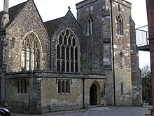
St Martin's Church (Church of England)
Salisbury was an important centre for music in the 18th century. The grammarian James Harris, a friend of Handel, directed concerts at the Assembly Rooms for almost 50 years up to his death in 1780, with many of the most famous musicians and singers of the day performing there.[58]
Salisbury holds an annual St George's Day pageant, the origins of which are claimed to go back to the 13th century.
Salisbury has a strong artistic community, with galleries situated in the city centre, including one in the public library. In the 18th century, John Constable made a number of celebrated landscape paintings featuring the cathedral's spire and the surrounding countryside. Salisbury's annual International Arts Festival, started in 1973, and held in late May to early June, provides a programme of theatre, live music, dance, public sculpture, street performance and art exhibitions. Salisbury also houses a producing theatre, Salisbury Playhouse, which produces between eight and ten plays a year, as well as welcoming touring productions.
Salisbury Museum
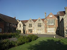
Salisbury Museum, housed in the King's House.
The Salisbury Museum is housed in the King's House, a Grade I listed building whose history dates back to the 13th century, opposite the west front of the cathedral.
The permanent Stonehenge exhibition gallery has interactive displays about Stonehenge and the archaeology of south Wiltshire, and its collections include the skeleton of the Amesbury Archer, which is on display.
The Pitt Rivers display holds a collection from General Augustus Pitt Rivers.
The costume gallery showcases costume and textiles from the area, with costumes for children to try on while imagining themselves as characters from Salisbury's past.
The former home of Sir Edward Heath is now open as a museum. The house, Arundells, is in the Cathedral Close.
Twin towns and sister cities
Salisbury has been twinned with Saintes, France, since 1990[59] and with Xanten, Germany, since 2005.[59]
Salisbury is also a sister city of Salisbury, North Carolina and Salisbury, Maryland, both of which are in the United States.[59]
Education
There are numerous schools in and around Salisbury. The city has the only grammar schools in Wiltshire: South Wilts Grammar School for Girls and Bishop Wordsworth's School, which is for boys and is located in the Cathedral Close. Also in the Close is Salisbury Cathedral School. Other schools in or near the city include the Chafyn Grove School, Leehurst Swan School, the Godolphin senior and prep school, St Edmund's Girls' School, Sarum Academy, St Joseph's Catholic School and South Wiltshire UTC.
Sixth form education is offered by Salisbury Sixth Form College, while the Salisbury campus of Wiltshire College offers a range of further education courses, as well as some higher education courses in association with Bournemouth University. Sarum College is a Christian theological college located within the Cathedral close in Salisbury.
Transport
Road
The main transport links for the city are the roads. Salisbury lies on the intersection of the A30, the A36 and the A338 and is at the end of the A343, A345, A354 and A360. Car parks around the periphery of the city are linked to the city centre by a park and ride scheme (see details in the bus section below). The A36 forms an almost complete ring road around the city centre. The A3094 comprises the southwestern quadrant of the ring road, passing through the city's outer suburbs.
The lack of adequate roads is a cause of concern to the people of Salisbury: as there is no motorway to link the ports of Southampton and Bristol, traffic passes around the city's ring-road via the A36 to Bath.
Bus
There are bus links to Southampton, Bournemouth, Andover, Devizes and Swindon, with limited services on Sundays. Salisbury Reds, a brand of Go South Coast, is the main local operator. Wheelers Travel provide services to Shaftesbury and Andover, as well as intermediate-distance services.[60] Other operators include Stagecoach (Amesbury, Tidworth, Andover); Beeline (Warminster); and First (Warminster, Trowbridge, Bath).[61]
Salisbury has a Park and Ride bus scheme with five sites around the city. The scheme attempts to relieve pressure on the city centre, but as of 2010, ran at an annual loss of £1 million.[62] The sites, which are funded by Wiltshire Council and cost £2.50 for parking and bus transport for an individual or £3.50 for up to six passengers, are:[63] 501 Beehive – A345 Castle Road to the north, 502 Wilton – A36 Wilton Road to the west, 503 Britford – A338 Downton Road to the south, 504 London Road – A30 London Road to the northeast, 505 Petersfinger – A36 Southampton Road to the southeast.[62]
Salisbury Bus Station, which opened in 1939, closed in January 2014 due to high operating costs and the fact that only a third of Salisbury Reds services called there.[64] Situated in Endless Street, on the northeastern edge of the city centre, the site was later developed into retirement homes, which opened in February 2018.
Railways
Salisbury railway station is the crossing point of the West of England Main Line, from London Waterloo to Exeter St Davids, and the Wessex Main Line from Bristol Temple Meads to Southampton Central. The station is operated by South Western Railway. Great Western Railway hourly trains call from Cardiff Central, Bristol Temple Meads, Bath Spa to Southampton Central and Portsmouth Harbour.
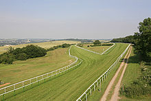
Salisbury Racecourse with the cathedral in the distance
Sport and leisure
The city has a football team, Salisbury F.C., who play in the Southern League Division One South & West and are based at the Raymond McEnhill Stadium, on the northern edge of the city. Non-league clubs are Bemerton Heath Harlequins F.C. and Laverstock & Ford F.C..
Salisbury Rugby Club, which is based at Castle Road, play in National League 3 South West.
South Wilts Cricket Club is based at the Salisbury and South Wiltshire Sports Club and play in the Southern Premier Cricket League, which they have won five times in the past 25 years. They produce many juniors who represent both Hampshire and Wiltshire at county level.
Winterbourne Cricket Club is based in Winterbourne Gunner and Farley Cricket Club is based at Coronation Field, Farley.[65][66] Salisbury Hockey Club is also based at the Salisbury and South Wilts Sports Club.[67]
The Five Rivers Leisure Centre and Swimming Pool, which was opened in 2002, is located just outside the ring road. Salisbury Racecourse is a flat racing course to the south-west of the city. Five Rivers Indoor Bowls Club and Salisbury Snooker Club share a building on Tollgate Road, behind the College. The Bishop's Walk on the edge of the city provides a popular viewing point.
Old Sarum Airfield, north of the city centre, is home to a variety of aviation-based businesses, including flying schools and the APT Charitable Trust for disabled flyers.
The city's theatre is the Salisbury Playhouse. The City Hall is an entertainment venue and hosts comedy, musical performances (including those by the resident Musical Theatre Salisbury) as well as seminars and conventions. Salisbury Arts Centre, housed in a redundant church, has exhibitions and workshops.
Salisbury is well-supplied with pubs. The Haunch of Venison, overlooking the Poultry Cross, operates from a 14th-century building; one of its attractions is a cast of a mummified hand, supposedly severed during a game of cards.[68] The Rai d’Or has original deeds dating from 1292. It was the home of Agnes Bottenham, who used the profits of the tavern to found Trinity Hospital next door in circa 1380.
Some buildings in Salisbury are reputed to be haunted. Ghost tours are popular with locals and visitors. One such building is the local Odeon cinema, located in the Hall of John Halle, which is the oldest building in the UK to contain a cinema. The Debenhams department store is said to be haunted by Henry Stafford, 2nd Duke of Buckingham; the store is on the site where he was beheaded in 1483.
Notable people
Before 1900
John of Salisbury (c.1120–1180) [69] author, educationalist, diplomat and bishop of Chartres, born at Salisbury
Simon Forman (1552 in Quidhampton, Fugglestone St Peter – 1611) [70] astrologer, occultist and herbalist
John Bevis (1695 in Old Sarum – 1771) [71] doctor, [72] electrical researcher and astronomer, discovered the Crab Nebula in 1731
James Harris FRS (1709–1780) [73] politician [74] and grammarian, born and educated in Salisbury
James Harris, 1st Earl of Malmesbury GCB (1746 in Salisbury – 1820) [75] diplomat, politician and MP- Sir John Stoddart (1773 in Salisbury – 1856) [76] writer and lawyer, and editor of The Times
Sir George Staunton, 2nd Baronet (1781 at Milford House near Salisbury – 1859) [77] traveller and Orientalist
Henry Fawcett PC (1833 in Salisbury – 1884) [78] academic, statesman and economist
John Neville Keynes (1852 in Salisbury – 1949) [79] economist and father of John Maynard Keynes- Sir James Macklin, DL, JP (1864 in Harnham – 1944) [80] jeweller, farmer and six times Mayor of Salisbury 1913/1919
Herbert Ponting FRGS (1870 in Salisbury – 1935) [81] professional photographer, the expedition photographer and cinematographer for Robert Falcon Scott's Terra Nova Expedition
Lieutenant James Cromwell Bush MC (1891 in Salisbury – 1917) [82] World War I flying ace
Lieutenant Colonel Tom Edwin Adlam VC (1893 in Salisbury – 1975) [83] recipient of the Victoria Cross
Since 1900
William Golding (1911–1993)[84] novelist, schoolteacher, taught Philosophy in 1939, and English from 1945 to 1961 at Bishop Wordsworth's School
Daphne Pochin Mould (1920 in Salisbury – 2014)[85] photographer, broadcaster, geologist, traveller, pilot and Ireland’s [86] first female flight instructor
John Rowan (1925 in Old Sarum - 2018 in London) author, one of the pioneers of Humanistic Psychology and Integrative Psychotherapy
Ray Teret (born 1941 in Salisbury)[87] radio disc jockey and convicted rapist,[88] sentenced to 25 years in prison in 2014
Iona Brown OBE, (1941 in Salisbury – 2004 in Salisbury)[89] violinist and conductor, from 1968 to 2004 lived in Bowerchalke- Sir Jeffrey Tate CBE (1943 in Salisbury – 2017)[90] conductor of classical music
Jonathan Meades (born 1947 in Salisbury)[91] writer, food journalist, essayist and film-maker- Prof. Martyn Thomas CBE FREng FIET FRSA (born 1948 in Salisbury)[92] software engineer, entrepreneur and academic
Kenneth Macdonald, Baron Macdonald of River Glaven QC (born 4 January 1953)[93] Director of Public Prosecutions (DPP) of England and Wales 2003–2008 and head of the Crown Prosecution Service; attended Bishop Wordsworth's School in Salisbury
Carolyn Browne CMG (born 1958)[94] diplomat, Ambassador to Kazakhstan; attended South Wilts Grammar School for Girls
Teresa Dent CBE (born 1959)[95] CEO of Game & Wildlife Conservation Trust, lives in Salisbury
Martin Foyle (born 1963 in Salisbury)[96] professional footballer and manager, played 533 League games, scoring 155 goals
Joseph Fiennes (born 1970 in Salisbury)[97] film and stage actor, educated in the town
Dave Dee, Dozy, Beaky, Mick & Tich (formed 1964)[98] 1960s pop/rock group, most of whom came from Salisbury or Wiltshire
Clare Moody (born 1965)[99] Labour Member of the European Parliament (MEP) for South West England, lives in Salisbury
Max Waller (born 1988 in Salisbury), professional cricketer who plays for Somerset County Cricket Club
Henni Zuël (born 1990 in Salisbury)[100] professional golfer, youngest player to join the Ladies European Tour as an amateur
Media
Salisbury is served by two local radio stations: Spire FM is the city's Independent Local Radio station, and BBC Wiltshire is the BBC Local Radio public service station for the whole county. Regional television services are provided by BBC South and ITV Meridian, and a local television channel "That's Salisbury" is provided by That's TV.
The Salisbury Journal is the local paid-for weekly newspaper, which is available in shops every Thursday. The local free weekly newspaper from the same publisher is the Avon Advertiser, which is delivered to houses in Salisbury and the surrounding area.
Bordering areas
Neighbouring areas of Salisbury | ||||||||||
|---|---|---|---|---|---|---|---|---|---|---|
| ||||||||||
In popular culture
- Salisbury is the origin of "Melchester" in Thomas Hardy's novels, such as Jude the Obscure (1895).
- A lively account of the Salisbury markets, as they were in 1842, is contained in Chapter 5 of Martin Chuzzlewit by Charles Dickens.
- The fictitious Kingsbridge Cathedral in TV miniseries, The Pillars of the Earth (2010), based on a historical novel by the same name by Ken Follett, is modelled on the cathedrals of Wells and Salisbury. The final aerial shot of the series is of Salisbury Cathedral.[101][102]
- The novel Sarum by Edward Rutherfurd describes the history of Salisbury.
- The novel The Spire by William Golding tells the story of the building of the spire of an unnamed cathedral similar to Salisbury Cathedral.
- The Andy McNab novel For Valour in the Nick Stone series, in which the titular character visits friends in the city.
- Band Uriah Heep released an album and song called Salisbury in 1971.
- Progressive rock band Big Big Train wrote two songs in their Folklore album in which the Salisbury Giant[103] appears.
See also
- Salisbury Cathedral
Salisbury steak, which is not named after the city but after an James Salisbury, an American physician
References
- Footnotes
^ Other pronunciations include /ˈsɔːlzbəri/ SAWLZ-bər-ee[2] and /ˈsɒlzbəri/.
- Notes
^ abcd UK Census (2011). "Local Area Report – Salisbury Parish (1170219621)". Nomis. Office for National Statistics. Retrieved 18 March 2018..mw-parser-output cite.citationfont-style:inherit.mw-parser-output .citation qquotes:"""""""'""'".mw-parser-output .citation .cs1-lock-free abackground:url("//upload.wikimedia.org/wikipedia/commons/thumb/6/65/Lock-green.svg/9px-Lock-green.svg.png")no-repeat;background-position:right .1em center.mw-parser-output .citation .cs1-lock-limited a,.mw-parser-output .citation .cs1-lock-registration abackground:url("//upload.wikimedia.org/wikipedia/commons/thumb/d/d6/Lock-gray-alt-2.svg/9px-Lock-gray-alt-2.svg.png")no-repeat;background-position:right .1em center.mw-parser-output .citation .cs1-lock-subscription abackground:url("//upload.wikimedia.org/wikipedia/commons/thumb/a/aa/Lock-red-alt-2.svg/9px-Lock-red-alt-2.svg.png")no-repeat;background-position:right .1em center.mw-parser-output .cs1-subscription,.mw-parser-output .cs1-registrationcolor:#555.mw-parser-output .cs1-subscription span,.mw-parser-output .cs1-registration spanborder-bottom:1px dotted;cursor:help.mw-parser-output .cs1-ws-icon abackground:url("//upload.wikimedia.org/wikipedia/commons/thumb/4/4c/Wikisource-logo.svg/12px-Wikisource-logo.svg.png")no-repeat;background-position:right .1em center.mw-parser-output code.cs1-codecolor:inherit;background:inherit;border:inherit;padding:inherit.mw-parser-output .cs1-hidden-errordisplay:none;font-size:100%.mw-parser-output .cs1-visible-errorfont-size:100%.mw-parser-output .cs1-maintdisplay:none;color:#33aa33;margin-left:0.3em.mw-parser-output .cs1-subscription,.mw-parser-output .cs1-registration,.mw-parser-output .cs1-formatfont-size:95%.mw-parser-output .cs1-kern-left,.mw-parser-output .cs1-kern-wl-leftpadding-left:0.2em.mw-parser-output .cs1-kern-right,.mw-parser-output .cs1-kern-wl-rightpadding-right:0.2em
^ "Salisbury". Collins Dictionary. n.d. Retrieved 23 September 2014.
^ Mills, David. A Dictionary of British Place-Names. Oxford University Press, 2003.
^ Reed, Langford (1934). "Irreverent Radios". Mr. Punch's Limerick Book. London: R. Cobden–Sanderson Ltd. p. 65.
^ ab Salisbury limerick
^ Roberts 1811, p. 135.
^ Welsh Prose 1300–1425. "Oxford Jesus College MS. 111 (The Red Book of Hergest) – page 147r: Trioedd Ynys Prydain, Cas Bethau, Enwau ac Anrhyfeddodau Ynys Prydain", col. 600. University of Cardiff (Cardiff), 2014. (in Old Welsh)
^ Roberts, Peter (1811). The Chronicle of the Kings of Britain; Translated from the Welsh Copy Attributed to Tysilio; Collated with Several Other Copies, and Illustrated with Copious Notes; to Which Are Added, Original Dissertations. London: E. Williams. pp. 150–151.
^ Nennius, (Traditional attribution). Mommsen, Theodor. ed (in la). Historia Brittonum. VI. Wikisource.
^ Newman, John Henry; et al. (1844). "Chapter X: Britain in 429, A.D.". Lives of the English Saints: St. German, Bishop of Auxerre. London: James Toovey. p. 92.
^ English Heritage. Old Sarum, p. 22. (London), 2003.
^ abcdef "Salisbury: Thumbnail History". Wiltshire Community History. Wiltshire Council. Retrieved 14 October 2016.
^ Leeds, E.T. "The Growth of Wessex" in Oxoniensia, Vol. LIX, pp. 55–56. Oxford Architectural and Historical Society, 1954. Accessed 6 October 2011.
^ Hunt, William (1898). . In Lee, Sidney. Dictionary of National Biography. 55. London: Smith, Elder & Co. p. 202.
^ ab British History Online. Fasti Ecclesiae Anglicanae 1066–1300, Vol. IV, "Salisbury: Bishops". Institute of Historical Research (London), 1991.
^ Dolan, John Gilbert (1910). . In Herbermann, Charles. Catholic Encyclopedia. 9. New York: Robert Appleton Company.
^ Bergh, Frederick T. (1912). . In Herbermann, Charles. Catholic Encyclopedia. 13. New York: Robert Appleton Company.
^ Swanson, R.N. Religion and Devotion in Europe, c. 1215–c. 1515, pp. 148 & 315. Cambridge University Press (Cambridge), 1995.
ISBN 0-521-37950-4.
^ The Ecclesiologist, p. 60.
^ "Old Sarum" at Sacred Destinations. Accessed 10 September 2010.
^ ab Chisholm, Hugh, ed. (1911). . Encyclopædia Britannica. 23 (11th ed.). Cambridge University Press. p. 454.
^ Davis, R.H.C. (1977). King Stephen. London: Longman. p. 31. ISBN 0-582-48727-7.
^ ab
Storer, James (1819). History and Antiquities of the Cathedral Churches of Great Britain. 4. London: Rivingtons. p. 73.
^ Frost, Christian (2009). Time, Space, and Order: The Making of Medieval Salisbury. Bern: Peter Lang. p. 34.
^ ab Ledwich 1777, pp. 253 ff. quotes John Leland
^ ab Prothero, George Walter (1858). The Quarterly Review. John Murray. p. 115.
^ Ledwich, Edward (1777). "Appendix of Original Records, with Observations". Antiquitates Sariſburienſes: The History and Antiquities of Old and New Sarum Collected from Original Records and Early Writers. Salisbury: E. Easton etc. p. 260.
^ https://www.forbes.com/2008/02/28/oldest-work-clock-oped-time08-cx_po_0229salisbury.html#266d099e31f3
^ Easton, James. A Chronology of Remarkable Events Relative to the City of New Sarum, with the Year, and the Name of the Mayor in whose Time they occurred: Chiefly collected from the authentic Sources of the City Records, and Manuscripts of Citizens, From A.D. 1227 to 1823, a Period of 596 Years, Including the Prices of Wheat and Barley from an Early Æra: To which are added, Their annual Average Prices for 28 Years, Being from 1796 to 1823, 5th ed., p. 1. J. Easton (Salisbury), 1824.
^ Oram. Canmore Kings, p. 109.
^ "Parliaments held away from Westminster" (PDF). House of Commons Library. 12 November 2012. Archived from the original (PDF) on 2015-06-09. Retrieved 10 February 2018.
^ 17 Charles II. Cap. 12. 2 March 1664.
^ Priestley, Joseph. Historical Account of the Navigable Rivers, Canals, and Railways, of Great Britain, as a Reference to Nichols, Priestley & Walker's New Map of Inland Navigation, Derived from Original and Parliamentary Documents in the Possession of Joseph Priestley, Esq., p. 37. Longman, Rees, Orme, Brown, & Green (London), 1831. Hosted at Wikisource.
^ Childs, J. The Army, James II, and the Glorious Revolution. (Manchester), 1980.
^ "Russian spy: What we know so far". BBC News. Retrieved 2018-04-06.
^ "Election Maps". Ordnance Survey. Retrieved 14 February 2018.
^ http://citypopulation.de/php/uk-england-southwestengland.php?cityid=E34004306
^ "1963 Temperature". KNMI.
^ "2006 temperature". UKMO.
^ "2010 temperature". Tutiempo.
^ "Boscombe Down 1971–2000". UKMO. Retrieved 9 November 2011.
^ "Boscombe Down extreme values". KNMI. Retrieved 9 November 2011.
^ Compiled Neighbourhood Statistics
^ Neighbourhood Statistics. "British government census statistics for race and ethnicity". Neighbourhood.statistics.gov.uk. Retrieved 2 May 2014.
^ http://ukcensusdata.com/salisbury-st-edmund-and-milford-e05008389#sthash.q5dDiWHA.dpbs
^ http://ukcensusdata.com/salisbury-st-francis-and-stratford-e05008390#sthash.ip2PlcAF.dpbs
^ UK Census (2011). "Local Area Report – Salisbury Built-up area (1119883473)". Nomis. Office for National Statistics. Retrieved 6 April 2018.
^ Neighbourhood Statistics. "British government census statistics for country of birth". Neighbourhood.statistics.gov.uk. Retrieved 2 May 2014.
^ ab Neighbourhood Statistics. "British government census statistics for religion". Neighbourhood.statistics.gov.uk. Retrieved 2 May 2014.
^ Neighbourhood Statistics. "British government census statistics for main language". Neighbourhood.statistics.gov.uk. Retrieved 2 May 2014.
^ Neighbourhood Statistics. "British government census statistics for proficiency in English". Neighbourhood.statistics.gov.uk. Retrieved 2 May 2014.
^ Neighbourhood Statistics. "British government census statistics for age". Neighbourhood.statistics.gov.uk. Retrieved 17 July 2010.
^ http://www.salisburycitycouncil.gov.uk/c/charter-market
^ "Wiltshire Community History". Wiltshire Council. Missing or empty|url=(help);|access-date=requires|url=(help)
^ "Wiltshire". Gazetteer OF MARKETS AND FAIRS IN ENGLAND AND WALES TO 1516. Centre for Metropolitan History. Retrieved 12 April 2010.
^ Watts, John (1991)Salisbury Gasworks: The Salisbury Gas Light & Coke Company Salisbury: South Wiltshire Industrial Archaeology Society
ISBN 0-906195-12-8
^ Cork, Tristan (15 June 2015). "450 jobs to go in Salisbury as Aviva shuts Friends Life offices". Western Daily Press. Archived from the original on 13 July 2015. Retrieved 13 July 2015.
^ Music and Theatre in Handel's World: The Family Papers of James Harris 1732–1780, by Donald Burrows and Rosemary Dunhill, Oxford University Press, USA (29 March 2002)
^ abc "Twinning and Sister Cities". Salisbury City Council. Retrieved 7 March 2018.
^ "Bus times". Wheelers Travel. Retrieved 16 April 2018.
^ "Service 265 from April 2017" (PDF). First Group. Retrieved 16 April 2018.
^ ab Riddle, Annie (25 February 2010). "Park and ride losing £1million". Salisbury Journal. Retrieved 12 April 2010.
^ "Park and ride". Wiltshire Council. Retrieved 12 April 2010.
^ "Bus station closes after 75 years". BBC News: Wiltshire. 4 January 2014. Retrieved 16 April 2018.
^ "Winterbourne Cricket Club". Retrieved 17 March 2013.
^ "Farley Cricket Club". Retrieved 17 March 2013.
^ "Salisbury Hockey Club". Retrieved 17 March 2013.
^ "Mummified hand stolen from pub". BBC News: Wiltshire. 16 March 2004. Retrieved 19 May 2017.
^ Stanford Encyclopedia of Philosophy Archive retrieved 28 September 2017
^ Dictionary of National Biography, 1885–1900, Volume 19 retrieved 28 September 2017
^ SEDS Deep Sky Astronomers website retrieved 28 September 2017
^ Dictionary of National Biography, 1885–1900, Volume 04, Bevis, John retrieved 30 January 2018
^ Archive of The Royal Society retrieved 28 September 2017
^ Dictionary of National Biography, 1885–1900, Volume 25, Harris, James (1709–1780) retrieved 30 January 2018
^ Oxford Dictionary of National Biography Archived 17 September 2016 at the Wayback Machine retrieved 28 September 2017
^ Dictionary of National Biography, 1885–1900, Volume 54 retrieved 28 September 2017
^ Project Gutenberg retrieved 28 September 2017
^ The University of Glasgow Story retrieved 28 September 2017
^ A Cambridge Alumni Database, University of Cambridge retrieved 28 September 2017
^ The London Gazette, 30 December 1919 retrieved 29 September 2017
^ Royal Geographical Society biographical tribute retrieved 28 September 2017
^ The Aerodrome website retrieved 29 September 2017
^ Imperial War Museums retrieved 29 September 2017
^ "Obituaries: Sir William Golding". The Independent. 1993-06-21. Retrieved 2017-12-27.
^ Catholic Authors retrieved 29 September 2017
^ Irish Examiner retrieved 29 September 2017
^ Guardian newspaper retrieved 29 September 2017
^ Greater Manchester Police website
retrieved 29 September 2017
^ The Guardian, obituary retrieved 28 September 2017
^ The Guardian, obituary retrieved 28 September 2017
^ The New Statesman retrieved 28 September 2017
^ Institution of Engineering and Technology retrieved 29 September 2017
^ The Guardian retrieved 28 September 2017
^ Government website retrieved 29 September 2017
^ Game & Wildlife Conservation Trust website
retrieved 29 September 2017
^ Soccerbase retrieved 29 September 2017
^ The Guardian retrieved 28 September 2017
^ AllMusic Artist Biography by Craig Harris retrieved 28 September 2017
^ European Parliament website retrieved 28 September 2017
^ Daily Mirror website retrieved 29 September 2017
^ "Ken Follett on the Cathedrals in The Pillars of the Earth". Oprah.com. 3 May 2010.
^ Hale, Mike (22 July 2010). "Pillars of the Earth". New York Times.
^ "BBC - A History of the World - Object : The Salisbury Giant". www.bbc.co.uk. Retrieved 2018-04-29.
External links
| Wikimedia Commons has media related to Salisbury. |
Wikisource has the text of The New Student's Reference Work article "Salisbury". |
 Salisbury (England) travel guide from Wikivoyage
Salisbury at Curlie- Official tourism website
Let Me Tell You: Salisbury – a BBC film about life in the city in 1967 at BBC Wiltshire
Historic Salisbury photos at BBC Wiltshire
Wiltshire Portal | |
| Unitary authorities |
|
| Major settlements |
|
| Rivers |
|
| Topics |
|
Authority control |
|
|---|