Provinces of Algeria
Algeria |
|---|
 |
This article is part of a series on the politics and government of Algeria |
Constitution
|
Executive
|
Legislature
|
Subdivisions
|
Elections
|
Foreign relations
|
|
Algeria is divided into 48 wilayas (provinces) and 1541 baladiyahs (municipalities, in French: commune). The capital city of a baladiyah, daïra, or province (which is also the largest city of those) always gives those entities their name, even Algiers, the capital of the country gave it its name (El Djazayar, the Arabic name for both the city and the country).
According to the Algerian constitution, a wilaya is a territorial collectivity enjoying economic and diplomatic freedom, the APW, or "Popular Provincial Parliament/Provincial Popular Parliament" (the Assemblée Populaire Wilayale, in French) is the political entity governing a province, directed by the "Wali" (Governor), who is chosen by the Algerian President to handle the APW's decisions, the APW has also a president, who is elected by the members of the APW, which is elected by Algerians.
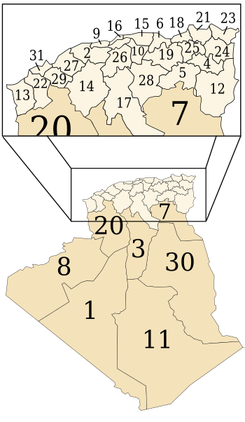
List

Act Number 84-09 of 4 February 1984 relative to the organisation of the Algerian territory and as updated and complemented by Act Number JO of 7 February 1984 fixed the number of Algerian Provinces at 48 and established the list of municipalities or "communes" attached to each Province.
The Province numbers are the first 31 provinces (see the second section) in Arabic alphabetical order, after the adding of 17 other provinces in 1983, the old numbering was kept and the 17 new provinces have been assigned codes from 32-48, in Arabic alphabetical order.
The following table presents the list of provinces, showing for each province, its numerical code, its name (which is in all times the same as the name of the capital city of the province), the number of districts "daira"s in each province, the number of municipalities as well as the province area and its population.
| Code | Province | ولاية | Number of Districts | Number of Municipalities | Area | Population (2008[1]) | Density (2008) | ||
|---|---|---|---|---|---|---|---|---|---|
| km² | mi² | per km² | per mi² | ||||||
| 01 | Adrar | أدرار | 11 | 28 | 439,700 | 169,800 | 399,714 | 0.94 | 2.4 |
| 02 | Chlef | الشلف | 13 | 35 | 4,795 | 1,851 | 1,002,088 | 209 | 540 |
| 03 | Laghouat | الأغواط | 10 | 24 | 25,057 | 9,675 | 455,602 | 18 | 47 |
| 04 | Oum el-Bouaghi | أم البواقي | 12 | 29 | 6,783 | 2,619 | 621,612 | 81 | 210 |
| 05 | Batna | باتنة | 21 | 61 | 12,192 | 4,707 | 1,119,791 | 92 | 240 |
| 06 | Béjaïa | بجاية | 19 | 52 | 3,268 | 1,262 | 912,577 | 279 | 720 |
| 07 | Biskra | بسكرة | 12 | 33 | 20,986 | 8,103 | 721,356 | 34 | 88 |
| 08 | Béchar | بشار | 12 | 21 | 162,200 | 62,600 | 270,061 | 1.7 | 4.4 |
| 09 | Blida | البليدة | 10 | 25 | 1,575 | 608 | 1,002,937 | 591 | 1,530 |
| 10 | Bouïra | البويرة | 12 | 45 | 4,439 | 1,714 | 695,583 | 157 | 410 |
| 11 | Tamanghasset | تمنراست | 7 | 10 | 556,185 | 214,744 | 176,637 | 0.32 | 0.83 |
| 12 | Tébessa | تبسة | 12 | 28 | 14,227 | 5,493 | 648,703 | 46 | 120 |
| 13 | Tlemcen | تلمسان | 20 | 53 | 9,061 | 3,498 | 949,135 | 105 | 270 |
| 14 | Tiaret | تيارت | 14 | 42 | 20,673 | 7,982 | 846,823 | 41 | 110 |
| 15 | Tizi Ouzou | تيزي وزو | 21 | 67 | 2,956 | 1,141 | 1,127,608 | 316 | 820 |
| 16 | Algiers | الجزائر | 13 | 57 | 1,190 | 460 | 2,988,145 | 2,511 | 6,500 |
| 17 | Djelfa | الجلفة | 12 | 36 | 66,415 | 25,643 | 1,092,184 | 46 | 120 |
| 18 | Jijel | جيجل | 11 | 28 | 2,577 | 995 | 636,948 | 247 | 640 |
| 19 | Sétif | سطيف | 20 | 60 | 6,504 | 2,511 | 1,489,979 | 229 | 590 |
| 20 | Saïda | سعيدة | 6 | 16 | 6,764 | 2,612 | 330,641 | 49 | 130 |
| 21 | Skikda | سكيكدة | 13 | 38 | 4,026 | 1,554 | 898,680 | 223 | 580 |
| 22 | Sidi Bel Abbès | سيدي بلعباس | 15 | 52 | 9,096 | 3,512 | 604,744 | 66 | 170 |
| 23 | Annaba | عنابة | 6 | 12 | 1,439 | 556 | 609,499 | 424 | 1,100 |
| 24 | Guelma | قالمة | 10 | 34 | 4,101 | 1,583 | 482,430 | 118 | 310 |
| 25 | Constantine | قسنطينة | 6 | 12 | 2,187 | 844 | 938,475 | 427 | 1,110 |
| 26 | Médéa | المدية | 19 | 64 | 8,866 | 3,423 | 819,932 | 92 | 240 |
| 27 | Mostaganem | مستغانم | 10 | 32 | 2,175 | 840 | 737,118 | 325 | 840 |
| 28 | M'Sila | المسيلة | 15 | 47 | 18,718 | 7,227 | 990,591 | 53 | 140 |
| 29 | Mascara | معسكر | 16 | 47 | 5,941 | 2,294 | 784,073 | 132 | 340 |
| 30 | Ouargla | ورقلة | 10 | 21 | 211,980 | 81,850 | 558,558 | 2.6 | 6.7 |
| 31 | Oran | وهران | 9 | 26 | 2,121 | 819 | 1,454,078 | 688 | 1,780 |
| 32 | El Bayadh | البيض | 8 | 22 | 78,870 | 30,450 | 228,624 | 3.2 | 8.3 |
| 33 | Illizi | اليزي | 3 | 6 | 285,000 | 110,000 | 52,333 | 0.18 | 0.47 |
| 34 | Bordj Bou Arréridj | برج بوعريريج | 10 | 34 | 4,115 | 1,589 | 628,475 | 160 | 410 |
| 35 | Boumerdès | بومرداس | 9 | 32 | 1,356 | 524 | 802,083 | 504 | 1,310 |
| 36 | El Taref | الطارف | 7 | 24 | 3,339 | 1,289 | 408,414 | 122 | 320 |
| 37 | Tindouf | تندوف | 1 | 2 | 159,000 | 61,000 | 49,149 | 0.31 | 0.80 |
| 38 | Tissemsilt | تسمسيلت | 8 | 22 | 3,152 | 1,217 | 294,476 | 93 | 240 |
| 39 | El Oued | الوادي | 12 | 30 | 54,573 | 21,071 | 647,548 | 12 | 31 |
| 40 | Khenchela | خنشلة | 8 | 21 | 9,811 | 3,788 | 386,683 | 40 | 100 |
| 41 | Souk Ahras | سوق أهراس | 10 | 26 | 4,541 | 1,753 | 438,127 | 95 | 250 |
| 42 | Tipaza | تيبازة | 10 | 28 | 1,605 | 620 | 591,010 | 273 | 710 |
| 43 | Mila | ميلة | 13 | 32 | 3,407 | 1,315 | 766,886 | 220 | 570 |
| 44 | Aïn Defla | عين الدفلى | 14 | 36 | 4,891 | 1,888 | 766,013 | 156 | 400 |
| 45 | Naâma | النعامة | 7 | 12 | 29,950 | 11,560 | 192,891 | 6.5 | 17 |
| 46 | Aïn Témouchent | عين تموشنت | 8 | 28 | 2,379 | 919 | 371,239 | 156 | 400 |
| 47 | Ghardaïa | غرداية | 9 | 13 | 86,105 | 33,245 | 363,598 | 4.2 | 11 |
| 48 | Relizane | غليزان | 13 | 38 | 4,870 | 1,880 | 726,180 | 152 | 390 |
| Total | Algérie | الجزائر | 547 | 1541 | 2,381,741 | 919,595 | 34,080,030 | 14 | 36 |
1974-1983
The 15 départments were reorganized to form 31 provinces:
1 Adrar
2 Chlef
3 Laghouat
4 Oum el-Bouaghi
5 Batna
6 Béjaïa
7 Biskra
8 Béchar
9 Blida
10 Bouira
11 Tamanghasset
12 Tébessa
13 Tlemcen
14 Tiaret
15 Tizi Ouzou
16 Algiers
17 Djelfa
18 Jijel
19 Sétif
20 Saïda
21 Skikda
22 Sidi Bel Abbes
23 Annaba
24 Guelma
25 Constantine
26 Médéa
27 Mostaganem
28 M'Sila
29 Mascara
30 Ouargla
31 Oran
1957-1974
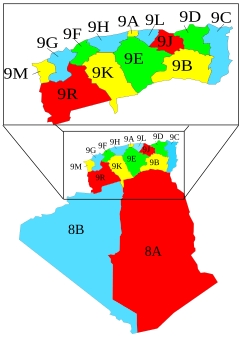
Immediately after independence, Algeria retained its 15 former French départements, which were renamed wilayas (provinces) in 1968, for the most part, with some name changes:
- 9A-Alger (Algiers)
- 9C-Annaba (Formerly Bône, English: Bona)
- 9B-Batna
- 9D-Constantine
- 9H-Orléansville (Then El Asnam, now Chlef)
- 8A-El Wahat (Currently Ouargla, formerly Oasis)
- 9E-Médéa
- 9F-Mostaganem
- 9G-Oran
- 9R-Saïda
- 8B-Saoura (Currently Béchar)
- 9J-Sétif
- 9K-Tiaret
- 9L-Tizi-Ouzou
- 9M-Tlemcen
1954-1962
During the Algerian War of Independence, the FLN adopted an organizational system divided by 6 numbered wilayas:
- Aurès
- Constantine
- Kabylie
- Algiers
- Oran
- Sahara
See also
- Municipalities of Algeria
- List of Algerian Provinces by population
- List of Algerian Provinces by area
- ISO 3166-2:DZ
References
^ Office National des Statistiques, Population par sexe, âge et Wilaya. Consulted on 02/02/2016.
External links
(in Arabic) ولايات الجزائر
(in French) Les wilayas d'Algérie
(in English) The provinces of Algeria
Algeria articles | |||||
|---|---|---|---|---|---|
| History |
|  | |||
| Geography |
| ||||
| Politics |
| ||||
| Economy |
| ||||
| Society |
| ||||
| |||||
Provinces of Algeria | ||
|---|---|---|
| ||


