Algiers Province
Algiers Province ولاية الجزائر | |
|---|---|
Province | |
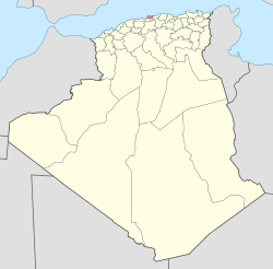
 Map of Algeria highlighting Algiers | |
| Coordinates: 36°42′N 3°13′E / 36.700°N 3.217°E / 36.700; 3.217Coordinates: 36°42′N 3°13′E / 36.700°N 3.217°E / 36.700; 3.217 | |
| Country | |
| Capital | Algiers |
| Government | |
| • PPA president | Mohamed Zaïm (FLN) |
| • Wāli | Abdelkader Zoukh (since 2013) |
| Area | |
| • Total | 1,190 km2 (460 sq mi) |
| Population (2008)[1] | |
| • Total | 2,988,145 |
| • Density | 2,500/km2 (6,500/sq mi) |
| Time zone | UTC+01 (CET) |
| Area Code | +213 (0) 21 |
| ISO 3166 code | DZ-16 |
| Districts | 13 |
| Municipalities | 57 |
Algiers (Arabic: ولاية الجزائر Wilāyat al-Jazāʼir, French: Wilaya d'Alger) is a province (wilayah) in Algeria, named after its capital, Algiers, which is also the national capital. It is adopted from the old French département of Algiers and has a population of about 3 million. It is the most densely populated province of Algeria, and also the smallest by area.
Contents
1 Administrative divisions
1.1 Districts
1.2 Communes
2 People
3 References
4 External links
Administrative divisions
Algiers province is divided into 13 districts and 57 communes or municipalities.
Districts
The districts, listed according to official numbering (from west to east), are:
1. Zéralda | 8. Sidi M'Hamed | 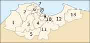 The 13 districts of Algiers province |
Communes
The communes, listed alphabetically, are:
- Alger Centre
- Aïn Bénian
Aïn Taya (Ain-Taya)- Bab El Oued
- Bab Ezzouar
- Baba Hassen
Bachdjerrah (Bach Djerrah)- Baraki
- Ben Aknoun
- Bir Mourad Raïs
Birkhadem (Bir Khadem)- Birtouta
Bologhine (Bouloghine)- Bordj El Bahri
Bordj El Kiffan (Bordj El Kifan)- Bourouba
- Bouzaréah
- Béni Messous
- Casbah
- Chéraga
- Dar El Beïda
- Douéra
- Draria
Dély Ibrahim (Dely Brahim)- El Achour
- El Biar
- El Harrach
- El Madania
- El Magharia
- El Marsa
- El Mouradia
- Djasr Kasentina
- H'raoua
- Hammamet
- Hussein Dey
- Hydra
- Khraïcia
- Kouba
- Les Eucalyptus
- Mahelma
- Mohamed Belouizdad
- Mohammedia
- Oued Koriche
- Oued Smar
- Ouled Chebel
- Ouled Fayet
- Rahmania
- Raïs Hamidou
- Reghaïa
- Rouïba
- Saoula
Sidi M'Hamed (Sidi Mhamed)- Sidi Moussa
- Souidania
- Staouéli
- Tessala El Merdja
- Zéralda
People
Lyès Deriche, 20th-century leader of the Algerian national political movement against the French.
References
^ Population résidente des ménages ordinaires et collectifs (MOC) selon la wilaya de résidence et le sexe et le taux d’accroissement annuel moyen (1998-2008) Office National des Statistiques.
External links
(in French) "Alger, Capitale previligiée pour l'investissement" (Archive) - National Agency of Investment Development (Agence Nationale de Développement de l'Investissement or ANDI, الوكالة الوطنية لتطوير الاستثمار)
| Zéralda District |
|  |
|---|---|---|
| Chéraga District |
| |
| Draria District |
| |
| Birtouta District |
| |
| Bir Mourad Raïs District |
| |
| Bouzaréah District |
| |
| Bab El Oued District |
| |
| Hussein Dey District |
| |
| Sidi M'Hamed District |
| |
| El Harrach District |
| |
| Baraki District |
| |
| Dar El Beïda District |
| |
| Rouïba District |
| |
Provinces of Algeria | ||
|---|---|---|
| ||


